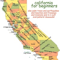
Chromogeography
Behold Data Pointed‘s VISUALIZATIONATOR:

Place names are turned into color: blue is water, green is land, red is manmade.
The West Coast is much prettier than the East Coast or Europe (except for the leaves in fall, I will grant you that).
Colors are stacked additively, so cities appear yellow. Bigger maps on the lovely Data Pointed emergent visualization portal.
Added bonus: Data Pointed is now on Twitter.
Acme, The Once and Future Beer
While cleaning out my garage (read: shifting around boxes that I haven’t opened in 10 years and three moves), I came across this rather awesome bottle cap jammed in a truss:

While the font seemed relative fresh, it had a cork and foil liner, so I figured it was not that new.

I did a little historical digging (big surprise, I know) and it looks like my bottle cap dates from the mid to late 1930s, right after Prohibition ended.

(Note to historical hunters — bottle caps are called “crowns”. You’d think Bert would have taught us this important fact. (And sorry if you’re going all Ernie on this post.))
Acme was a transplant brewery from Seattle. Not many breweries made it through the 1906 earthquake and fire, and millions of dollars of beer were shipped from Seattle and bottled here. Within a year, the Olympia brewery converted the bottling plant into a full brewery, and Acme was born. (Brewery Gems has lots on Acme Brewing in SF from the first half of the 20th century.)

(April 11, 1907, via SFPL’s Chronicle archive)
Acme was located at the foot of Telegraph hill, on 1401 Sansome (between Greenwich & Lombard).

In the 1920s, Several breweries merged to form the California Brewing Association (including several in the Mission) but only Sansome St and the National Brewery at Fulton and Webster were kept open. (Sansome St was sold off in 1929). They survived Prohibition by making Acme Light “near beer” with 0.5% alcohol (along with vinegar and syrup) but ramped back up after the 1933 Repeal.
Side note: Acme sure had it going on when it came to fonts. Some 1933 shots:

(1933, Repeal, via North Coast Brewing)

(1933, delivery truck, via SFPL)
Acme started advertising “real” beer before Prohibition officially ended and got a significant leg up on the competition. It served them well in the beginning:
via Brewery Gems:
After Repeal Acme Breweries built a new bottling plant adjacent to the old National site at Fulton & Webster. The new plant was described by architects and designers as “one of the worlds most beautiful industrial buildings.”


The Fulton plant had a rather nice view of City Hall (via North Coast Brewing)

Alas, Acme’s streamlined plant wasn’t built until 1941, so my 30s-era bottle cap came from more humble origins on Webster between Fulton and Grove.

After the war, Acme Brewing struggled to compete against the national breweries but didn’t make it. The SF plant was sold in 1954 to an East Coast company attempting to go national, but the site was closed in 1958, and our sleek building was torn down in 1968 (SFPL):

The Acme brand survived however, and has popped up as a contract beer every decade for the past 40 years. Today, Fort Bragg’s North Coast Brewing (e.g. Red Seal, Brother Thelonius) owns the rights and makes an Acme IPA and Pale Ale (which I am certain taste far better than what was once under my 75 year old bottle cap).

They also have an Acme museum. Hooray! Drink Acme, the once and future beer!
I am going to thoroughly confuse future owners of my house by jamming new Acme bottle caps beside the old one in that same truss.
Eastern Mystery
Let’s just say I do not normally see this.

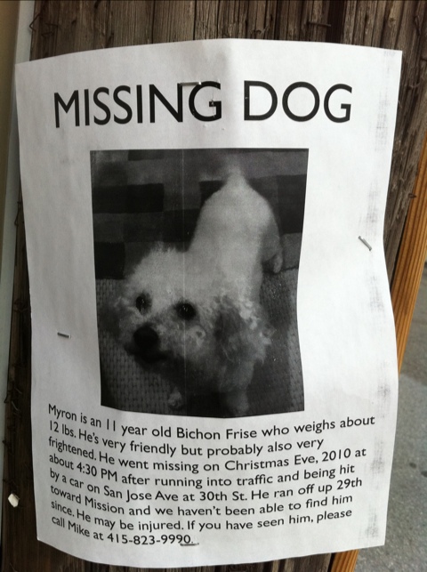
Help Myron The Dog Find His Way Home
Be on the lookout, La Lengua (and Bernal).
Islands of San Francisco (The Poster)
After at least 300 iterations, behold a poster of my San Francisco map — if neighborhoods were islands, and streets canals.
Order on Zazzle — 23″ x 23″ for $25, 15″ x 15″ for $16. 11″ x 11″ for $11.
A bit late to ship for Christmas — why not start a tradition of giving maps in the New Year?

Backstory here for those who don’t remember (or want to savor the 107 comments). But my image of the Valencia Street Canal is what started it all:


I want the 26-Valencia to come back as a gondola!
La Lengua Dining / Wining Renaissance
La Lengua has long held an impressive stable of dining establishments, including Blue Plate, Front Porch, Baby Blues BBQ, Caffeinated Comics, El Zocalo, Zante’s Pizza, Pi Bar and Anthony’s Cookies to name a few.
But behold the changes afoot in La Lengua. Recently opened are Ichi Sushi (Mission across from Safeway) & Locavore (Mission at Valencia).
Changes to come include Belinda’s -> The Royal Cuckoo. Also, it seems the SoCha Cafe is turning into a wine bar?

Does that say “Dell Uva”? Is that the same place as in North Beach? Hooray, wine!
Transamerica Cone of Invisibility
Mission / La Lengua / Bernal residents hold a deep, dark secret.
The glorious Transamerica Pyramid is invisible to us, thanks to the unfortunate placement of the evil and golem-like Bank of America tower.
@rrmutt has named this tragically sad shadow “The Transamerica Cone of Invisibility” and took the time to map it out. I took the liberty of extending his work INTO THE THIRD DIMENSION (click to download a rather epic Google Maps kmz file).
For those not willing to eat 115% of your CPU, some screenshots from the GE KMZ:
The view of the B of A shadow of darkness:

Why B of A building, what an attractive air conditioning unit you have upon your glorious crown!

The Bernal / La Lengua / Mission NPZ (no-pyramid zone):
![]()
A rare look INSIDE the cone of invisibility:

(Hey Transamerica Pyramid, this is what you’re missing — dude, I just realized you get NO good burritos.)
Anyway, one edge of the shadow dissolves towards the eastern, lower part of Bernal Hill (aka “dogtown”). Sadly, my planned surveying session from atop Bernalwood got called on account of rain.
However, before Sunday’s maelstrom started, I *did* get the chance to explore the western shadow line from the rarely explored and little-known land of “Diamond Heights”.
I walked a curve from DH Blvd to Walter Haas playground (above Billy Goat Hill), then down between Everson and Digby, and on to the very edge of the world, Fairmont Plaza (nope, I had never heard of it before either).
I stitched together a quick animated GIF of the Sadly Disappearing Transamerica Pyramid:

Along the way, it of course started pouring rain, though for my readership I persevered, sacrificing both my physical and electronic health (ok, not really, but it was pretty rainy and visibility really started to suck — the fuzzier shots are me shooting through the rain, trees, or a combination thereof while standing in mud).
However, the rain and clouds let let me get a couple of fairly interesting shots:
The lines of San Bruno Mountain.

Sutro Tower could have been built here, but the FAA nixed it. But my favorite San Bruno Mountain story is the guy who wanted to level it and use it to fill the Bay (no I’m not kidding).
“…this barrier which otherwise would continue to plague San Francisco and the Peninsula FOREVER. Also, eliminating this barrier would provide more land for homes, cemeteries, and rapid transit facilities; and it would remove the ever-present hazard of plane crashes against this mountain.” (more here)
Obligatory Sutro Tower shots:


How can you not love that thing?
I do love Bernal when it gets all green. This particular angle makes the old quarry pretty obvious.

Hunters Point Shipyard, and the sun beyond the Bay.


Anyway, Billy Goat Hill and Fairmont Plaza FTW!
De Young Guard Tower
We Built This City got a rare look at the top of the fabled guard observation tower at the de Young.

I took WBTC’s five shots from the middle of Golden Gate Park and stitched it into a panorama:

Lincoln Park to Sutro, in the house! 225º and 5000 pixels (click to zoom).
GGB and a secret Sutro:

La Lengua and Bernalwood Co-Prosperity Treaty
After years of negotiations (including much beer and pizza) the denizens of La Lengua are happy to announce a treaty of co-operation and co-prosperity with the Dominion of Bernalwood.

Treaty text is available in full from the Bernalwood digital archives:
RESOLVED: We, the overlords of Bernalwood, do cede La Lengua to the denizens of same, and that funny name too. However, La Lenguans should be advised that as the overlords of Bernalwood, and being far more vain and glamorous, we shall in perpetuity claim La Lengua within our own Greater Sphere of Co-Prosperity and Influence, and that we shall retain certain Rights and Privileges regarding various Establishments contained within La Lengua, particularly as they pertain to eateries and gun shops along Mission Street, and the Liminal Area thereabouts.
Please note that nosotros, el pueblo de La Lengua hereby consider the MSLA (Mission Street Liminal Area) be as open and clear, upon one condition:

LaLeRA (La Lengua Revolutionary Army) shall make NO EFFORT to block or restrict free trading activities in or around liminal areas (including any and all eating, drinking, tourist and shooting establishments).
These shall be considered areas of FREE NAVIGATION upon the condition that Bernal support the construction of THE 30TH STREET BART STATION.
RESOLVED: This treaty shall be celebrated in a La Lenguan eating/drinking establishment in short order.
SF Infrastructure Baby Pictures
Awwww, cute! Sutro and the Transamerica Pyramid’s baby pictures!
![]()
Via SFPL and Transamerica. (Is anyone else having trouble with the SFPL photo archive?)
You can also follow them on Twitter — @SutroTVTower and @TransAmericaBdg — there’s some serious sibling rivalry going on there.
TransAm: “I’m older.”
Sutro: “Well, I’m taller.”
TransAm: “He’s cheating by standing on a hill!”
Sutro: “At least I’m not standing on a boat.“
Me: IF YOU TWO DON’T STOP I’M PULLING THIS CITY OVER RIGHT NOW.
Though I love the reference to the Niantic. Touché, Sutro, touché.
Anyway. The SF Anthropomorphized list is getting rather extensive. (And rather neurotic.)
So in 1973 Sutro had (or was supposed to have) white lights running up its legs, but neighbors complained and we were left with just the red aviation safety lights — if this was the case does anyone have pictures? Those would be awesome, I want them turned back on.
Also, a period quip: “Sutro Tower is the packing case that the TransAmerica Pyramid came in.”