The Islands of San Francisco
May 7, 2010
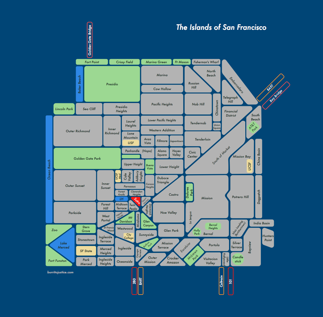
If San Francisco neighborhoods were islands, and the streets canals:

2011 UPDATE: now available as a poster!
Click to zoom. (I’ve really got to figure out a wider WordPress template.) Updated May 9, 10, 11, 12, 14, 16, 17, 19, 26.
Map inspired by Kyle Sluder’s SOAS (Seattle on a Sheet). Unfortunately Market St, Columbus, Mission, Geneva/Ocean and 280 make it impossible to follow Kyle’s rectilinear model, but I think it worked out rather nicely.
Man, the more I think about it, canals would be AWESOME. (Panorama, click to zoom.)


(Water images borrowed from here, lost the link to the kayak shot, v. sorry Internet.)
And don’t forget the future canals in Mona Caron’s mural at 15th and Church:


Things I learned:
- Yes, I probably left some stuff out, and yes I probably hosed the alignment of your hood. Please don’t invade the Mission, just let me know in the comments.
- SWSF has a ton of little neighborhoods that I am barely aware about, never mind know the borders of – I guess Republicans like tiny neighborhoods?
- Ingleside is a bit of a mystery – you seem to be non-contiguous. And Merced? Do you really exist? Thinking there’s some serious consolidation opportunities down there, not familiar enough with it to make a call. I hate to use Stonestown as a neighborhood name but hey, there’s an Apple Store there.
- I really don’t know where Downtown and the Financial District start and stop. And I don’t think Embarcadero is really a neighborhood, but you know what I meant.
- I like the look of the Market, Mission, 101 and 280 canals.
- Shapes with rounded corners are a bitch to align.
- UPDATE: v2: nudged a bunch of borders, modified Silver Terrace/Bayview, added Telegraph Hill, Lone Mountain, Anza Vista, Ashbury Heights, Parnassus, Caltrain (v1 is here (if you have too much time on your hands)).
- UPDATED UPDATE: v3: modified Oceanview, Ingleside, Sunnyside, added City College (much easier to see where Ocean Ave is); added UCSF Medical Center, Mt Davidson, Stern Grove; tons of modifications around Twin Peaks (easier to see Portola canal), adjusted Laguna Honda hood vs lake (WTF?), shrunk Twin Peaks; shrunk down the Zoo / Lake Merced / Funston (v2 is here).
- SURPRISE SURPRISE: v4 brings us Dolores Park island, Hospital Curve, and endless tweaking of the Twin Peaks neighborhoods (v3 is here).
- FIFTH TIME’S THE CHARM: v5: adjusted Sea Cliff and Presidio Heights; bifurcated the Sunset and Richmond; once again screwed around with Mt Sutro and friends; added India Basin and adjusted Hunter’s Point; added China Basin; added Union Square; adjusted Civic Center and Tenderloin; and perhaps most controversially, I added the Tendernob. Comprehensive twitternet research has revealed that it absolutely is a neighborhood, while completely not one, sort of a wave-particle duality. It’s Schrödinger’s neighborhood. (v4 is here)
- GROWING WEAK, OXYGEN LOW: v6, good god, it just doesn’t stop. But really wasn’t happy with the area adjacent to 280 (especially the catch-all Outer Mission) so redrew it to better show Ocean and Geneva which turned out to be a HUGE PAIN IN THE ASS. Yes, I know Cayuga Terrace / Mission Terrace / Balboa Park aren’t that large but the scale gets seriously wonky in that part of the map. It just wasn’t possible to get O+G as a diagonal line. Also corrected Visitacion, re-added Merced Heights. (v5 is here)
- HAIGHT MACHINE: v7, since apparently Upper and Lower Haight don’t actually touch at Divisidero (who knew?) and there’s no clearly defined name for the DMZ between Masonic and Divis (though I am partial to SOAK — South of Oak.) So I decided to piss everyone off by flanking Buena Vista and the Panhandle as a buffer between the warring tribes. And while I was at it, I double labeled the latter as Nopa just to further annoy those who don’t like the name. (For the record I am suspect of Nopa, but a) people know where it is and b) this is after all a map. (But I refuse to InterCap it.)) Added Clarendon Heights; also lots of tweaks to Cole Valley; and Parnassus, WTF, are you trying to circle Cole Valley? You stay up on the hill, I am calling your lower section Ashbury Heights until someone bitches about it. (v6 is here)
- INDUSTRIAL ZONE, WESTERN SUBTRACTION: v8 – Sunday Streets taught me there’s a big difference between Silver Terrace, Bayview and my inelegantly moniker “Industrial Zone” (between 280 and 101). Also modified Western Addition, and unfortunately included Lower Pac Heights (ugh, what a stupid name, but people know where it is, sigh…) Western Addition is a tricky one because of historical significance — once vast, at this point is it seems more of an overlay of AV, Fillmore, JT, HV, AS, and Nopa? So do we start doing islands within lakes within islands? (v7 is here)
- BUTCHERTOWN, ISLAIS LANDING: v9 – The warehouse/industrial area between 101 and 280 doesn’t really have a name but I’m hard pressed to call it Bayview since it’s not residential. 80 years ago it was the marshy outlet of Islais Creek, and the adjacent area near 3rd was called Butchertown.
So using the powers vested in me by this blog, I hereby declare the area as Islais Landing / Butchertown (because let’s face it, Butchertown is too cool a name to waste). Also widened the blue border to make it more sea-like, and added a title. Appended ‘Hill’ to Potrero, and added Holly Park because a) I like it, and b) it seems different than Bernal. (v8 is here) - DIVISIDATION: v10, per recommendation of natives, flipped Western Addition and the Anza Vista/Fillmore/Japantown row. But as previously noted, that whole area is tough to do since Western Addition is both an overlay (Van Ness to Divis) as well as a container for other historical areas (Fillmore) and trendihoods. Sadly my efforts at drawing an archipelago of Fillmore-AV-JT-HV-AS in Lake Addition have failed. (v9 is here)
- POSTER TIME: St. Mary’s and a few tweaks. Do go and Zazzle yourself a poster here.
151 Comments
leave one →
Trackbacks
- Look: The Islands (and Canals) of San Francisco - Ünnecessary Ümlaut
- Ciudad de México Has Been Sinking (Not Me) « Burrito Justice
- Tyranny of the Valley « Burrito Justice
- Islands of San Francisco (The Poster) « Burrito Justice
- SF Islands Poster! « Mission Mission
- Islands of San Francisco « Fog City Foodie
- Burrito Justice Holiday Suggestions « Burrito Justice
- San Francisco Archipelago « Burrito Justice
- Cities and Urban Environments | Pearltrees
- Sites for reference / content ideas | SF Native Guide
- Quora
- Mapping San Francisco « Roundup Rawhide
- Reappearance of the Islands of SF « Burrito Justice
- The Reemergence of the Islands of SF « Burrito Justice
- You’ve Tried The Rest, Now Try The Best « Burrito Justice
- So You Want To Move To San Francisco And Start Blogging | Midnight Breakfast
- What are some cool maps of San Francisco? | Matt Crowe 's Blog
- So You Want To Move To San Francisco And Start Blogging | Midnight Breakfast Midnight Breakfast
- Getting oriented in San Fransisco | Breaking in the Bay Starting a life in sf
- Centaur in Brass 2041 - Shareable
- Seattle on a Sheet – Kyle Sluder


Cool map! We had a helluva time making a San Francisco map with basically 2-dimensional boundaries, back when we did it in 1996 for our first iteration of Shaping San Francisco. I like yours better, mostly because you have more neighborhoods! We had weird limitations in memory space, so we had 22 neighborhoods, which led to some really odd ones like Western Addition+ and TenderNob+… anyway, very nice! and I like the 22nd and Valencia canals… have you seen my novel “After The Deluge”, a San Francisco partially under water in 150 years?… I’ll give you one!
cheers!
-cc
Sure, would love to read it! And do you have a copy of your map?
tell me where to send or drop it off. I’m near 24th and Folsom where you could pick it up too… that old map is “lost” and only available to see on an old PC running Windows2000 or earlier. I have an old laptop here that you can see it on, but it’s only electronic…
–cc
Chris, if you will email me the file, I will find a way to convert it and open it on new machines.
Returnoftheyeti at msn dot com
I have a recurring dream that the Mission Bay area is all canals instead of streets, and I’m on a MUNI boat (!) in a new warehouse district…
somebody has too much time on their hands.
Says the guy commenting on a blog.
more ideas here from last month:
http://brainslip.blogspot.com/2010/04/unfunded-but-fun-transportation-project.html
I’d kill for that Mission-Dogpatch tunnel, especially if it hit the 22nd St Caltrain. More like 5 minutes!
A while back, TJ had the idea for a gondola network based out of Sutro.
Given the Whistler-Blackcomb gondola only cost $52 million to build, I’m all over taking money from Muni. A Bernal-Sutro-Richmond line would give the 24 and 48 a serious run for their money.
this is one of the more accurate neighborhood maps i’ve seen of SF, in terms of neighborhood inclusion. only quibble i have is that i mostly know the area you’ve marked as upper market as ashbury heights. also, i like that you have discounted NOPA.
Good point on Ashbury Heights. But what’s the difference between that and Parnassus / Buena Vista?
The map is awesome! I’m off to walk El Corazon this afternoon.
I think the area labeled Embarcadero could be renamed Barbary Coast
Nudged a bunch of borders and fixed some corners.
Added Telegraph Hill, Lone Mountain, Anza Vista, Ashbury Heights, Parnassus, Caltrain.
Nice! I’m glad to see another map which extends the western boundary of the Mission far enough to include our park. ;)
Possession is 9/10s of the law, though I suppose that Dolores Park should really span the Mission/Castro canal. (While I could make a map of the divisions of the park itself, fractals frighten and confuse me.)
Oh, man, laser cutter for a MONTH? Jealous. I expect great things.
I guess the canal builder forgot to think about all of our hills and the effect of gravity on water..LOL>
We plan on using specially trained Hetch Hetchy water that understands the use of the conditional tense.
You’re so clever.
Thanks!
I’d say that most, if not all, of Midtown Terrace is north of Laguna Honda — I’d switch those two.
For neighborhoods, I see what you mean. But I can’t quite figure out why the actual laguna isn’t actually in Laguna Honda the neighborhood. Must be slipping down the hill.
Seriously, now. How am I gonna get my car across those canals? I don’t see any bridges.
What, BMW doesn’t make boats? How about a General Lee type ramp?
In all seriousness, you just gave me an idea – with a few bridges per island the map would turn into an awesome game of RISK.
Friends of Burrito Justice, you like to play Risk? Gotta try Warfish.net. I’ve done Risk maps of Portland bike routes and the U.S. electoral college. Working on a map of the moon. Drop your email, I’ll send you an invite…
Brilliant – and charming. We need vaporetti instead of buses, too, to run us through those canals.
Neighborhood note: The island you have called Ingleside Heights is actually Oceanview. Ingleside as I understand it is the eastern end and north slope of the same E-W ridge, on City College’s south and west sides. You could insert a Balboa Park island for the low areas east of City College and Balboa Park BART, but it’s not much more than a park + high school. Ingleside Terrace is in the valley bounded on the west by Junipero Serra, organized around Urbano Street, the old racetrack oval. Ingleside Heights is not familiar to me.
Gladys Hansen’s San Francisco Almanac does an excellent job defining neighborhoods, avant le deluge of realtor re-designations:
Super, super. I’m impressed, and as a micro-neighborhood connoisseuse, that’s rare. I think this is way more than adequate for most people, and the other discussions should be held snobbily in person (which is hard to do on the blog, but still…)
YAY for “awesome game of RISK”, YAY for multiple disclaimers that kept the comments civil (and snarky replies, YES) and YAY for your sourcing of all those cool images.
Thanks a lot, Mr. JohnnyO, for this.
v3:
– modified Oceanview, Ingleside, Sunnyside (much easier to see where Ocean Ave is), added City College
– added UCSF Medical Center, Mt Davidson, Stern Grove, green Panhandle
– tons of modifications around Twin Peaks, adjusted Laguna Honda hood vs lake (WTF?), made Portola canal more clear
– scaled down the Zoo / Lake Merced / Funston.
Nice. But remember, if you listen to us, you’ll just be modifying it till the cows come home and please nobody! I trust you to stick to your artistic vision and awesome ideas. I love the idea that it’s not just nabes, but actually (from what I understand!) how you interpret the City looking as islands, so landmarks get their inclusion. I’ll buy my bicycle pedal-powered paddle boat when you’re ready to go 2.0 with the experiment!
Er, can cows swim? Maybe Cow Hollow should be a lake.
Agreed on endless adjustments, but mainly adjusting areas I know little about. SWSF is a mystery to me, learning a lot.
Now to figure out where to put the bridges for RISK. What will be the Irktusk of SF?
I can’t believe you left off Dolores St. god, that would be the only canal with palm trees in the middle.
You know, that’s actually a good point. Thinking Dolores Park should be its own island. (Sorry Shawn.)
Yea, I definitely love the idea that Dolores Park should be an island..Actually, it seems to be one already..
Just make sure you provide adequate bmw parking.
You left out Popeye’s Gulch (1 block each side of Divisadero, roughly Fell to Golden Gate, between Alamo Square and Panhandle.) No, the realtors don’t call it that, but the residents do… google it.
And, where’s China Basin?
How strange. The night before you posted this I had a dream that SF was flooded & the streets were canals! As we frantically tried to save our belongings in trash bags, we started loading the bags into a boat. But one bag was tossed to hard and started drifting away from us. All I could do was wonder aloud, what was IN that drifting black bag, never to be seen again…oh well, at least we got to have a boat ride through the mission! :D
Ha, you and Mike need to get together and compare dreams.
You are so awesome for making this! Here are my suggestions that I didn’t see mentioned in the previous comments:
1. I think Presidio Heights is 2x as big as Sea Cliff, instead of the other way around.
2. I’ve only seen maps with Outer/Inner Richmond and the same for the Sunset. I think it would be more representative if Outer Richmond and Richmond were merged as just “Outer Richmond”, and same with the Sunset.
3. Civic Center/Downtown/Tenderloin…
– Civic Center’s north boundary is Turk, so it should really be cut off adjacent to Hayes Valley.
– While SF maps do have a “downtown” label for that area, I’ve only heard people use “downtown” to mean the entire downtown east of Van Ness and north of Market.
Here’s one way to reconcile (3):
a. Civic Center = triangle bordered by Hayes Valley and Lower Haight on the left, and Market St on the right.
b. Tenderloin = thin rectangle-oid bounded by Western Addition on the left, and Market St. on the right.
c. Union Square = small square under Chinatown.
d. Tendernob = between Nob Hill and Tenderloin (or just extend the Tenderloin if you’re not buying the Tendernob label).
Hey rego, thanks for the feedback, glad you like it.
1) Where does Presidio Heights stop? Is it Arguello? Park Presidio? Or 25th? i.e. does PH overlap the top of Richmond, and if so how far?
2) I’ve been wondering about the inner/outer Richmond/Sunset. If there is just inner/outer, where would each stop? Park Presidio? 19th? However, I have seen quite a few maps with ‘central’ Richmond and Sunset though. I don’t know those hoods well enough to make the call, consulting natives as we speak.
3a/b) Yeah, my Civic Center is too long, good point on the Hayes Valley/Lower Haight triangle. Though the Tenderloin has certainly attacked the CC BART/Muni station.
3c) Ha, I just added Union Square.
3d) Struggling over Tendernob. The line for Nob Hill is clear but is Tendernob a distinct entity?
Hi Johnny0, I’m amazed at how fast you’ve been updating everything and taking everyone’s input into account. :)
1) I’ve seen maps mark Presidio Heights as the north part of Laurel Heights, so I’d say it ends at Arguello and just becomes part of the Inner Richmond to the west.
2. From what I’ve seen, Inner Richmond ends at Park Presidio and Inner Sunset at 19th. I’m no expert either, though.
3d. Good question. As someone who used to live on Clay @ Powell, I can tell you it’s more Tenderloin than Nob Hill down there, but I wouldn’t say it has a distinct flavor…not yet at least!
Super cool. I could quibble about some details (including whether the Castro even exists or is still Eureka Valley, even after all these years), but that’s an endless argument. I live in what’s technically the Parkside, but it’s rare to meet someone who calls it that instead of the Sunset.
I’ve been wondering about Parkside.
Any feedback on Sunset subdivisions? Just an inner and outer? Or is there a central too?
That’s a good question about whether there’s more to the Sunset than Inner and Outer. I would say that in terms of architecture and feel, there definitely are more that two divisions of the Sunset District. One thing I’ve been thinking about a lot lately is that I think there is a westward-looking neighborhood feel to the parts of the Richmond roughly west of Lincoln Park and the Sunset west of Sunset Blvd. I think this transcends or supplements the traditional neighborhood borders. So from that point of view, the border of Ocean Beach could stand to move east a bit.
Yeah, I know what you mean about feel. It’s a fine line between a distinct neighborhood and an overlay.
Some history of Parkside here.
I’ve been toying around with doing a map of neighborhoods over time. I hope someone makes a nice HTML5 mapping tool.
I’m beginning to wonder if I am showing signs of obsessive compulsion. But anyway:
– adjusted Sea Cliff and Presidio Heights
– bifurcated the Sunset and Richmond
– once again screwed around with Mt Sutro and friends
– added India Basin and adjusted Hunter’s Point; added China Basin
– added Union Square
– adjusted Civic Center and Tenderloin
– perhaps most controversially, I added the Tendernob. Comprehensive twitternet research has revealed that it absolutely is a neighborhood, while completely not one, sort of a wave-particle duality. It’s Schrödinger’s neighborhood.
jeezus F. christ people. do you seriously call this stuff awesome and cool?
Is this what blogging has come to? making and remaking and tweaking fake little maps of a city just to pass the time? I can’t believe all the religiously written comments on what neighborhood is where and what should be adjusted and moved and spun around and shifted.
for gods sake. or whosever sake you want. can’t we talk about something more important? Like say, Laura Bush and her fucking hypocrisy on Larry King the other nite?
Now, don’t jump on me. I know. I have more time on my hands. I’m just venting.
Now I feel better.
I love San Francisco, her geography and history. I love discussing the intricacies of micro-neighborhoods. I think blog comment sections are a fun place to do this. I think “making and remaking and tweaking fake little maps of a city” is a cool process to watch.
Hahaha, you’re awesome. I seriously love the thought of you reading this each day.
I leave the political heavy lifting to Generic_ and 40 Going on 28
Just wait til we start doing microhoods.
Aw shucks. See, now we’re going to have to get TK to serve us drinks again! :-)
And, yeah political heavy lifting, that’s what you call it. I gotta say there are some awesome players on my RSS team… Wow, that was lame, but only halfway through morning espresso.
@johnny0 @TomPrete GREAT. Now you guys have enabled me spending all afternoon on WNP. If Woody LaBounty gets in on this, I will officially count this work day as lost. :-P
I heart the Parkside in a major way, having gone to Lowell (which is technically something like Merced Manor, with all those cool alleys behind the houses) and summer camp at Pine Lake (which is more like Pine Lake Park or something). Now I’m glad Woody’s not here and I’ll shut up now.
“Merced” should probably be “Park Merced.” I lived there five years, and I never heard anyone refer to that area as just plain old “Merced.”
Thanks for the confirmation – actually had Park Merced on the v1 map, whoops.
Actually, I’ve gotten a little more excited about the canals lately..I mean, I’m not going gaga over them but it’s got me thinking about designing locks in the canals.
Otherwise, being the designer that I am, I can’t figure how to get over Twin Peaks without a set of locks. I mean you gotta acknowledge the topography here. that part drives me fucking crazy.
And then there’s the waterfall potential too. Think of an awesome waterfall running down market st. say powering giant turbines at Castro, producing gazillion watts of electricity. And then, if you moved the Moby Dick bar near the turbines, what an awesome place to have a drink and watchem spin.
Great idea, man. And only gettin’ better with every update.
And thank you for not acknowledging NOPA.
::
As someone who currently lives on Masonic @ Anza, I’ve been telling people that I live in NOPA. Is that bad? I think if I said “Lone Mountain”, people would just scratch their heads.
While I know not the answer to this weighty question, I can say that feedback on Tendernob is 2/3 positive and the response on NOPA is almost the opposite, if not worse.
Re: Merced. Park Merced (is it one word? I forget) would be good to separate out (their marketing people might like that, Leona Helmsly, less so). But Merced Heights is a distinct entity (as part of OMI: Ocean View, Merced Heights, Ingleside) and could be chopped out of Ingleside Terraces, which is pretty small anyway. I feel like I was just telling myself I was going to leave this one alone… d’oh!
Addictive, isn’t it? I sort of had Merced Heights in v2 as “Merced” along with Park Merced
What about Ingleside Heights? Would MH references be sandwiched between IT and IH? Wouldn’t/shouldn’t Ingleside related activaty be contiguous? Arrrgh.
It should be “Visitacion” not “Visitation”:
http://en.wikipedia.org/wiki/Visitacion_Valley,_San_Francisco
And both are better than the common parlance of “viz-val”. :-)
Aaieee, that’s rather embarrassing. Thank you for pointing that out.
Rest assured I will never say viz val.
Fuck yeah.
That is all.
Good god, it just doesn’t stop. This would be much easier in a flatter city.
But really wasn’t happy with the area adjacent to 280 – I tend to think of it as a diagonal line when it’s really three big curves.
The catch-all Outer Mission got deprecated, and redrew things to better show Ocean and Geneva which turned out to be a HUGE PAIN IN THE ASS. Yes, I know Cayuga Terrace / Mission Terrace / Balboa Park aren’t that large but the scale gets seriously wonky in that part of the map. It just wasn’t possible to get O+G as a diagonal-ish line without unnatural cartographic acts like Greenlanding the Terraces.
Also corrected Visitacion, re-added Merced Heights.
Oh, and bmwlover, you have seen Burnham’s plans for SF, right?
Yea, Burnham’s plan was awesome. Can you imagine how much grander SF would have been with those streets laid out the way he did..?
Yea, I keep saying this thing about the hills…makes your challenge even harder I think. Think of the waterfalls..:)
Here’s a version for you with an asphalt black background instead of the figurative calming blue.
Nice…….I could zip around on those roads pretty cool.
Lenguists, Unite! There’s a new “nabe” rating site:
http://nabewise.com/sf
Can we agree that, in this bizarro-world scenario, the scant parts of SF that do currently have water would become giant asphalt plains? I like the idea of Lake Merced turning into a vast cement serengeti populated only by skateboarders and meth heads.
Also, I would like to request that bmwlover get his or her own forum on this blog, in which he/she vacillates between attacking the premise of the blog as self-indulgent and nerdy and then inexplicably getting really into it. Great stuff!
Seriously, Dan? LOL…you mean one is not entitled to have more than one viewpoint?
Do you love everything every single day? Do you hate everything every single day? Didn’t think so.
Neither do I. I’m a he, for the record.
Update, since apparently Upper and Lower Haight don’t actually touch at Divisidero (who knew?)
There’s no clearly defined name for the DMZ between Masonic and Divis (though I am partial to SOAK — South of Oak.) So I decided to piss everyone off by flanking Buena Vista and the Panhandle as a buffer between the warring tribes.
And while I was at it, I double labeled the latter as Nopa just to further annoy those who don’t like the name. (For the record I am extremely suspect of Nopa, but the fact remains a) people know where it is and b) this is after all a map. (But I refuse to InterCap it.))
Added Clarendon Heights; also lots of tweaks to Cole Valley; and Parnassus, WTF, are you trying to encircle Cole Valley? You stay up on the hill, I am calling your lower section Ashbury Heights until someone bitches about it.
Figures I made more changes RIGHT AFTER I ordered a test poster printed. Maybe it will be really valuable one day like a misprinted stamp and make future historians giddy with discovery.
i’m just gonna go ahead and toss this into the mix. if you wanna talk about islands, you have to consider Edgehill Mountain. it’s tiny, but it’s entirely bounded by the slopes of its namesake, self-identifies, and as far as i know, is the only place within SF where the city refuses to do upkeep on the road that winds to the summit.
http://spotsunknown.com/the-battle-for-edgehill-mountain/
Agreee, but need to wrap my head around how to draw this one.
Industrial Zone, Western Subtraction: Sunday Streets taught me there’s a big difference between Silver Terrace, Bayview and my inelegantly moniker “Industrial Zone” (between 280 and 101). Also modified Western Addition, and unfortunately included Lower Pac Heights (stupid name, but people know where it is…) Western Addition is a tricky one because of historical significance — once vast, at this point is it seems more of an overlay of LPH, AV, Fillmore, JT, HV, AS, and Nopa? So do we start doing islands within lakes within islands?
As per the yooj, your dedication is admirable. And daunting. Produce District, Sherwood Forest; going micro-micro could get all too tricky. As long as Glen Park is represented, I’m stoked! (And just such a bonus you put Noe VALLEY; I’m pretty sick of the shortening, although I pretty much gave up on Bernal HEIGHTS and Potrero HILL. Don’t know why people don’t use the old moniker Pot Hill…)
Good point on Potrero Hill (but hey, at least it’s not Portrero…)
I’m sure I’ll be screwing around with this for years, but I’m almost ready to make a poster.
First of all, amazing job on this v10 going on v∞ poster. I’m blown away.
I know this isn’t a forum for pushing personal district perceptions, but as you just mentioned that Lower Pac Heights is a “stupid name”, I’ve been trying to spread a new name for it… “Back-Pac” … makes sense, no?
Thanks for this, I’ve spent most of the day learning bout the “islands” of sf.
BackPac has definite potential. You ought to start a BackPac blog!
Indeed, I’ve been screwing around with SF neighborhoods since I was born in the Fillmore which is now Lower Haight and isn’t it all really Western Addition but not the part that got redeveloped so how much WA cred does it really have and on and on…
:-)
Poster, YES. One roommate might not be too stoked about our hallway becoming the SF poster and map museum, but I guess we’ll just have to spread them out around the place, won’t we?
Butchertown, Islais Landing: (v9) The warehouse/industrial area between 101 and 280 doesn’t really have a name but I’m hard pressed to call it Bayview since it’s not residential. 80 years ago it was the marshy outlet of Islais Creek, and the adjacent area near 3rd was called Butchertown.
So using the powers vested in me by this blog, I hereby declare the area as Islais Landing / Butchertown (because let’s face it, Butchertown is too cool a name to waste). Also widened the blue border to make it more sea-like, and added a title. Also added Hill to Potrero, and Holly Park because a) I like it and b) it seems different than Bernal.
Just so you don’t think I’m making shit up, this site has very cool maps of Islais Creek and Butchertown from 1869, 1926 and today.
(In Safari, you can drag one image over the other to do poor man’s time travel.)
The Farallon Islands are part of the City, even though they are uninhabited.
True, but real islands don’t count on this map. (Note no Treasure, Alcatraz, etc…)
Just a comment from my blog when I posted your map.
the Fillmore, unfortunately, is in the northern part of the Western Addition. As is Japantown. Anza Vista (which is technically where I live, though I call it the Eastern Subtraction) is west of Divisadero (http://en.wikipedia.org/wiki/Anza_Vista)- but Divisadero exists to define the westernmost edge of the Western Addition.
http://en.wikipedia.org/wiki/Western_Addition,_San_Francisco for a good bit of actual data on the particular neighborhood. I’d’ve probably flipped the anza-vista/fillmore/japantown belt and the western addition belt, one under the other: that’d satisfy my inclinations descriptionwise.
EASTERN SUBTRACTION FTW. Funniest thing I’ve heard all day, but then again, it’s just been me and the dog doing laundry. BUT STILL. My pops (who insists I spent the first two years of my life in the “Haight-Fillmore” at Page and Scott; we moved to Noe Valley when someone got shot outside of our house over a parking spot… hmm, maybe why I rock the bicycle?) will get a kick out of that one! Awesome, thanks.
Followed Jeremy over- I’d be the author he quoted on the comment, but more completely awake now. ;)
The annoying thing about AV/JTown/Fillmore is that they’re all nebulously-defined aspects of a larger neighborhood (the Western Addition) that’s btw Van Ness & Divisadero: the terms technically came into existence at the behest of real estate agents, to differentiate more aggressively gentrified portions of the Western Addition from the perceived negative value of WA as a name.
Anza Vista seems to be South of Geary & west of Divis, J-Town north of Geary (since it’s just a shopping mall whose name has been lent to a couple blocks around itself), and the Fillmore is both north and south of Geary, from Pac Heights down to lLwer Haight- almost a vertical corridor.
Maybe the way to handle it’d be an archipelago named the Western Addition, containing islands named the Fillmore, Alamo Square, Hayes Valley, Anza Vista, Japantown?
Love the map, though- as a (pretty-much) native, it does a brilliant job of capturing the way SF’s more a conglomeration of neighborhoods, rather than a big city.
Jeremy, Turner — totally agree this part of the map needs work. It is the bit I’ve struggled the most with, so thank you for posting.
Funny you mention the archipelago — I had an ‘experimental’ map with the Western Addition as a barrier island of sorts, surrounding Fillmore/Alamo/Hayes/AV etc. I may roll that back in given your comments. That, or figure out how to do some sort of “Western Addition Sea”. I’ll ping you guys once I get something mocked up.
— thi.
And what’s your take on Nopa?
@Johnny: Nopa was coined within this century to describe Masonic->Divis, Fell->Hayes- though I’ve seen it applied as far north as McAllister. I don’t actually find the moniker objectionable, but still- it’s actually a part of the Western Addition. The name ‘Divisadero’ comes from when the Western Addition was added- it was the division between what was the old Mission lands & the new Western Addition.
Now, if we’re going with real-estate usage (and a good chunk of common usage) rather than historical, then all that’s called ‘Western Addition’ anymore are between Golden Gate, Van Ness, Geary, and Divisadero- except when you’re near Fillmore, when you can then call it ‘Fillmore Jazz District’. Western Addition = oh no, icky projects! Think about the TenderNob appellation, as another example: it’s not the TENDERLOIN, heavens no… why, it’s practically part of Nob Hill!
I’ll bet you a fiver that when the westernmost of the evil evil evil Western Addition projects turn into condos & are sold to 30somethings (I think that’s about a decade out), we’ll have a new name for the few blocks btw Divis, Turk, Eddy and Fillmore: I’ll guess either ‘Divisadero Corridor’ or ‘West Fillmore’.
v10 per recommendation of natives, flipped Western Addition and the Anza Vista/Fillmore/Japantown row. But as previously noted, that whole area is tough to do since Western Addition is both an overlay (the addition to the west from Van Ness to, well, Divisidero) as well as a container for other historical areas (Fillmore) and trendihoods. Sadly my efforts at drawing an archipelago of Fillmore-AV-JT-HV-AS in Lake Addition have failed.
Trendihoods, love it!
Hi. We used this map and the Valencia canal pics to illustrate this short story, as part of our Shareable Futures series: http://shareable.net/blog/centaur-in-brass-2041
You’ll see that we gave full credit to Burrito Justice, and so hopefully you don’t mind. Thanks so much for this amazing project!
The best map I have seen! Keep Butchertown! Islais Creek/Butchertown is definitely a cool name and they can’t afford to lose it.
Can I repost this map to my yet to be live blog? Dispatch from Dogpatch is the blog and slated to go live July 7th. Will link it back to you
thanks love your blog
Certainly! Glad you like it. And I’m looking forward to Dispatch from Dogpatch!
Rave, rave, rave: Let me rave about your collectively interactively iteratively awesome map-making. So much fun. Thank you!
I bookmarked this site a while ago because of the interesting content and I have never been unsatisfied. Continue the outstanding work.
This is great, but I think you need to add one more “neighborhood”, St. Mary’s Park. It’s in the lower left hand of your current Bernal Heights. The two reasons that it needs to be id’d is (1) it’s the only neighborhood in SF that has it’s own flag (that I know of) and (2) most streets in it form the shape of a bell including the little part of the bell that makes the sound . The great thing about # 2 is that whoever developed this area actually cared enough to make the streets shape a bell. That would never happen today, they would be too concerned with maximizing space. But if you look at a map of the area (and if you actually drive it) the bell is very noticable.
Completely and totally agree. Just trying to figure how to fit in (and draw) a damn bell.
nice job.
I am especailly pleased that you correctly label the neighborhoods north of Haight as the Panhandle,Western Addition, etc. I am a bit disappointed to see the deservedly despised “Nopa” is in parens there, but I understand this concession to the uptight yuppie hoards that have infested the hood. (This label was coined by homeowners in the hood in the 90’s – I believe, my memory is getting foggy – and was quickly pounced upon by the real estate vulturati)
Please drop me an e-mail when these go on sale – as a Native San Franciscan in exile, I collect maps of the city and this would be a nice addition to my collection.
Huzzah
Kinda surprised nobody noticed that you have Oceanside in the Oceanview neighborhood.
Oceanside’s right next to Mercedside! :-P
Uh oh, guess I got on a roll with the side-side of town. (Oceanside, aka ZooView!)
Thanks, I’ll get that next week. Need to add St. Mary’s as well.
If St. Mary’s Park doesn’t go on next week, we’ll never meet the client deadline in time to invoice them so you can get paid for all your excellent work. OH WAIT………… :-P
Love the neighborhood map, but I’ve been googling for an old fashioned district map, not a neighborhood map, for at least 10 minutes now and haven’t found one yet.
I want a map with the “big picture”… Mission, Excelsior, Ingleside, Sunset, Richmond etc. It used to be easy to find, now it’s almost impossible.
If you pull up: http://thefrontsteps.com/ then scroll down to “Sites of Interest”, then click on “Detailed SF Districts Map”, you will start to download the PDF for the realtor’s map, that I often agree with. The MUNI map is available on their Web site, and the supervisorial districts are available on sfgov, too… Does that help?
This is a decent overview, though without borders (which is probably for the better).
Also, the guys at Stamen did a fanfuckingtastic job on the new Bing maps — when you get in close enough the neighborhood names pop up.
…very nice to see frisco FINALLY become amsterdam…
Did Oceanview accidentally turn into “Oceanside” in your later versions? (Oceanside was a neighborhood name for the Outer Sunset in the early 1900s, but isn’t in use these days)
Yeah, I had some revision control issues — I corrected it to -view but somehow I lost that change. It will be reverted soon, along with some other edits.
Oh, and it’s a common error (even in the neighborhood) to drop the “s” at the end of Ingleside Terraces. But as the gateway monuments proudly display, the terraces dey are plural.
Cool, I did not know that. Just found the Ingleside Terraces web site. Thank you.
Note: the “click to zoom” link is still linking to v9. Could we get the big v10 as a png, instead of a jpg? The quality of the png is much better.
Also, what’s your usage policy. Do you mind if I use a cropped version of your map on my blog, linking back to this post of course?
Hey Justin-
Thanks for the heads up – need to update a few things on this page.
Did you know there is a png version on the poster page? But let me know if you want a crop of particular neighborhood.
Is it possible to have the original vectorial file (psd?).
I’d love to be able to order a sticker of this that would fit on the inside of my messenger bag!
Alas we are a little sensitive with distributing the source vector data.
How big of a sticker were you thinking? Zazzle has some, but they don’t look to be that big (just 3″ or bumper).
Do you know of other sources for sticker printing?
I think 6” by 6” would fit nicely inside the flap of my chrome bag, without being too big.
I was recommended this one : http://www.stickergiant.com/, there might be other good options.
johnny0, did you know that the SF Association of Realtors has a wall-sized mural of your Islands of San Francisco map in the entrance of their building on the corner of Grove and Franklin? I noticed it on my walk to work today and stopped inside to take a photo. Send me an email if you want a copy. Since they credited “Burrito Justice” in the mural, I’m assuming you know—but who knows?
That. Is. Awesome.
Wondering how JohnnyO gets his 6%..? :-)
Yes! Pretty amazing, eh? Been working with them on it for the past couple of months. Look for a post on it next week when I can get some pictures!
Oceanview is mislabeled as Oceanside, which is a city in Southern California. Otherwise, awesome map. I show it to everybody I know that just moved here.
This map just opened the city up for my daughter. I think it’s brilliant. Thank- you
Love this, just wish it had the Yerba Buena Neighborhood carved out in SOMA. Yerba Buena is Market to Harrison and Second to Fifth Street and the Yerba Buena Gardens, the crown jewel is right in the center. Thanks!
Great map, but Parkside stops at Sunset Blvd
We have our own little island under the central freeway off ramp. No one knows what to call it or where it is. Market, Valencia, Otis, Duboce. Alleys Jessie, Stevenson, Elgin Park and Pearl.
looks awesome, what tools you use for making this map?
Stared fashionable prepare:
http://elmer.web.telrock.net
Rejuvenated net invent:
http://roxie.web1.telrock.net
cvv valid – fresh cvv, shopcvv ru
Oriol Romeu is also on the radar of his former club as Barcelona try to find competition for midfield anchorman Sergio Busquets.
9; 锟?5m fee with Monaco for midfield star Tiemoue Bakayoko on lucrative five-year dealinter and outInter Milan may be worst team ever for selling players before they reached their prime Both first-team regulars Eric Bailly and Marcos Rojo have come through unscathed so far whilst on international, whilst youngster Axel Tuanzebe is also available.