The Streets of Submerged San Francisco
Dec 18, 2072 (AP), Northern California Association of City States:
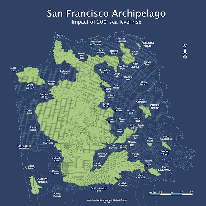
In the keynote speech of the 2072 AGU meeting at the New Moscone Convention Center on Nob Island, NASA and NCCS (Northern California Coast Survey) scientists have declared the stabilization of sea levels at 61 meters (200 ft) above 2012 sea level datum. Meltwater Pulse 1d followed the unexpected collapse of the Greenland and West Antarctic ice sheets, surpassing even the 20 meter, 200 year sea level rise during Meltwater Pulse 1a-1c 12,000 years ago that originally created old San Francisco Bay.
Bowing to public demand, SFMTA and SFDPW have finally approved the release of the San Francisco archipelago street maps showing both current and former streets created by centenarians Burrito Justice and Brian Stokle.
Detail:

(Note that the 200 ft topological maps are also available.)

Note: AP has opened its paywall for SF Archipelago articles from March 2072 and June 2072.
New transit and ferry lines have yet been finalized by the SFMTA and will be released in the holographic map in early 2073. Bridge placement is now open to discussion given the stabilized waterfront. (Also note that this map will be used to assess property taxes based depth of the property. All lots will continue to be taxed unless owners have taken advantage of the 220 sq foot sea dome tax credit. High tidal current regions in the Van Ness rapids and the Straight of St. Mary are exempt.)
The SFPUC has declared that all land reclamation efforts will have to be vetted in light of the unfortunate 2038 decision to raze the San Bruno mountains down to 150 feet for the relocation of the Google and Apple campuses. (On the other hand, the SF Port Commission has finally declared the Colma Passage to be navigable).
The SF Archipelago Board of Supervisors would specifically like to thank the SHSFPA (Submerged Historic San Francisco Preservation Association) for retrieving irreplaceable GIS data from the old City Hall data center as well as Stamen‘s former offices on 16th & Mission. Migurskibot 2.3 and Shawnbot 1.7 stated, “We thought those records were lost forever in 2032 when the Hurricane Ed breached the SoMa sea wall and the Mission permanently flooded.” These records will now be permanently stored off-world in the SFA’s lunar data center.
The SHSFPA also retrieved several invaluable al pastor and carnitas recipes from sunken taquerias. “The terrible reign of Chipotle Bell has ended — San Francisco has finally recaptured its burrito legacy.” The SF Department of Health will immediately approve any food boat applications using pre-flood menus. (Upon hearing this news, Burrito Justice and Brian Mount shook their fists in the air and immediately pushed their walkers to the dock to taste the first legitimate carnitas in 40 years.)
The updated SF archipelago street map is available in time for Christmas, shipping via Zazzle. It is available in the following two-dimensional poster form factors:
(Note: old-style US measurements, pre-inflationary dollars. Triple-blink for access to the 3D printer .obj file.)
Important Christmas shipping information: for former U.S. city-states with stabilized NewDollar economies, the poster can still be ordered as a present:
- Standard Boat delivery is available through midnight of Tuesday the 18th
- Premium Drone delivery is available through the midnight of Wednesday the 19th
- Express Railgun delivery can be chose up until 3PM on Thursday the 20th.
(Other regions and countries will vary depending on sea-level rise infrastructure recovery efforts and governmental stability.)
Trackbacks
- Visualizing Bernal Heights After Lots of Sea-Level Rise | Bernalwood
- RT @burritojustice: SF, 200 ft: http://t.co/CTmT6j… | /scratch/scupper
- Californian Cities Of San Francisco & Oakland File Lawsuits Against 5 Oil Companies For Role In Climate Warming & Rising Seas | CleanTechnica
- San Francisco & Oakland's Lawsuit Against 5 Oil Companies — More Depth & Context | CleanTechnica
- San Francisco and Oakland’s Lawsuit Against 5 Oil Companies — More Depth and Context
- San Francisco and Oakland Sue 5 Oil Companies For Role In Climate Warming and Rising Seas
- San Fransisco and Oakland sue big oil companies over the cost of climate change - Red, Green, and Blue
- “How are we going to pay for this?” agencies ask re: climate change costs? | Rapid Shift
- Islands of Seattle - Vivid Maps


Hurricane Ed. Ugh, if we’d only heeded the warnings!
Did you make that look like the Grinch on purpose?
Truly uncanny – SF does look like the Grinch. If that’s not a warning about sea level rise I don’t know what is. New slogan: “Don’t let seas rise to make SF into the Grinch! Let us stay as a funky square, or no worse than the Old Man in the Mountain!” (Think New Hampshire)
So there will be the wild parrot fish of Telegraph Island. Here’s a drawing of that, http://flic.kr/p/dQZkYK
Grinch? It really looks more like Jobba the Hutt with easter ears on.