Farallons via SF (and vice versa)
Wednesday was beautifully clear — I was stunned at how clearly I was able to see the Farallons, 27 miles away.
From Daly City, above Pacifica via iPhone + binoculars (but the field of view is pretty much what you’d see by naked eye)

The peak is 350 feet — for some perspective, that’s about half way between Bernal and Potrero.

(Strange to think that during the Ice Age it was just a big hill, and the coast was even further out. Makes you wonder what archaeological treasures are underwater. Also, the Bay was just a valley, and SF would have been way the hell inland, essentially the Orinda of the Pleistocene.
Did you know that when the BART tunnels were being built in 1972, they found 5000 year old human remains over 50 feet below Civic Center? They were once at ocean level but the area filled with sediment as sea levels rose after the ice age.)
I’ve always wanted to see SF from the Farallons. @theoverheadwire was nice enough to ask his cousin’s wife who was doing scientific research on the island take some photos. I jammed these together into a panorama (big surprise, I know).

4000 pixels wide, click to zoom. Labelled version (best to my knowledge, let me know if you think otherwise):

The GGB seems ridiculously far from downtown, no? Guess this really emphasizes what 7×7 really means.
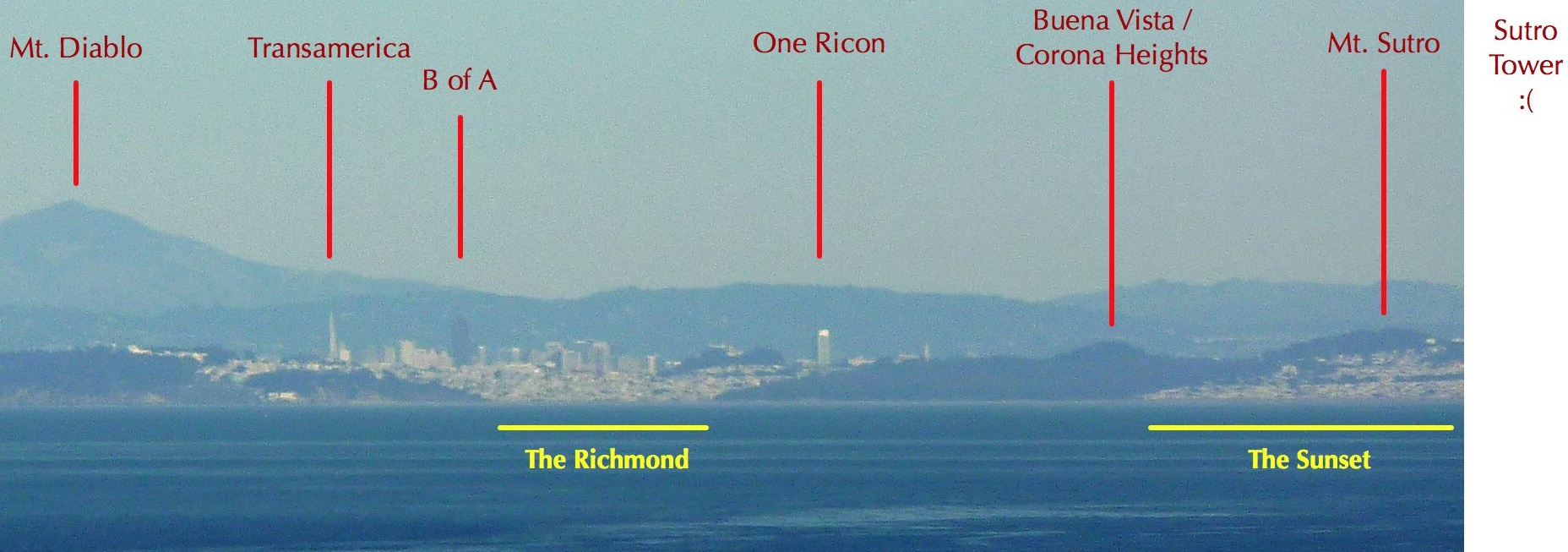
Crop of on downtown / Richmond / Sunset:

Tragically, Sutro Tower is just out of view. Guess I’ll have to rent a boat (full of beer, of course) and take some super zoom shots in the afternoon / sunset.
IMAGE UPDATE: Geoweb pointed out what I had originally labelled as Buena Vista / Corona Heights is actually Strawberry Hill in Golden Gate Park (400 feet, who knew? but it’s about half the height of the buildings so it makes sense) and what I had as Mt. Sutro is Buena Vista (575 feet). And troymcluresf noted that the bit I had as Sea Cliff was actually Lincoln & Pershing in the Presidio. I have no idea how long Baker Beach actually goes — there’s a Marshall Beach?
In a further effort to make your head implode, here’s what SF looks like from the other direction, via Mt. Diablo, 31 miles away:

Alas the Farallons aren’t visible in this shot. But here’s Sutro:


Thanks for this. I also love your dedication to Sutro Tower. It’s always been important to me and you seem to be building a following.
When I would occasionally get a clear view of the Farallons from my office at UCSF (it did happen a number of times a year), I was always surprised by how close they seemed. Like you could paddle out to them.
The one time I did the whale-watching ferry ride to the Farallons (not really a ferry, but some other kind of boat), it was fogged in all day and I couldn’t see the coast.
Thanks for the great photos, a very unique view indeed. To my eye, it looks like Buena Vista/Corona Heights is actually Strawberry Hill and Mt Sutro looks like Buena Vista… the white building at the lower right corner matches the building on Buena Vista between Upper Terrace and Java. But lovely no matter what.
Geoweb, this is a distinct possibility. I’ve constantly underestimated the x-axis on these distance shots.
I also had no idea Strawberry hill was so tall, 400 feet – it does seem to be around to be around half the height of the buildings.
More time in the Google Earth salt mines, it seems.
I agree on Strawberry Hill, and I think the “Seacliff” is really the houses above Lincoln in the Presidio. Seacliff is contiguous with the Richmond; there wouldn’t be any parkland between the two.
TMc, that makes sense.
Actually, Troy, I think you’re half right. Yes on Strawberry HIll, but while Sea Cliff is contiguous with The Richmond, Lincoln Park interrupts the shorline between the two. Google Maps, and my island map.
Annnnnnd we’re both right. There is a gap but that bit of Lincoln Park is pretty tiny, and you’re right about that other section is the Presidio (Lincoln Ave and Pershing) sticking out.
Image labels updated — Strawberry Hill added, Presidio / Seacliff and Buena Vista adjusted, Mt. Sutro removed, GGP and Baker Beach added. Thanks everyone.
aaaand today we learn that the WordPress iOS app is not to be trusted. It just backed in a bunch of edits from last week. Thanks guys!
Seriously, WordPress, just start over — your mobile app is fundamentally flawed.
Great shots. Very James Bond, those first ones. I thought of the Faralones (I think that’s the spelling?) this weekend when we boated out to an island off Saipan to dive. Hmm… Wonder what the diving it like off the Faralones? :-)
Um, Farallones…
Love that panorama shot from the Farallon.
Just don’t swim in that glassy area in the foreground of the image; that’s roughly the location of a radioactive waste dump site. More maps here (see Figure 2).
HOLY CRAP they sank the USS Independence out there?!?‽‽
First link points to a very good 2001 SF Weekly article.
Very cool shots. I know that others made some corrections, many of your labels seem to still be wrong. Here is a list of things that I noticed:
– Buena Vista correction was unnecessary: That is Mt. Sutro
– The Lincoln Park and Seacliff labels are wrong: The park above the “Lincoln Park” label is actually Sutro Heights. The building the area above “Seacliff” is actually part of the Richmond and the beginning of Lands End. You can see the Cliff House.
– The right half of the Baker Beach label is actually Lands End. The housing above the label is not SeaCliff, but actually the Baker Beach housing in the Presidio. Sea Cliff is not really visible, as it is hidden by Lands End/Lincoln Park.
– The Tennessee Valley label is actually Point Bonita.
One more thing that I noticed, the label on the last image in this post mislabels “Forest Hill.” That is actually Red Rock Hill in Diamond Heights.
Hope that all this helps. This is the bro of Friscolex.
Hey Frisbrolex!
I agree and disagree.
– You are right on Seacliff / Lincoln Park / Lands End / Baker Beach. LP sticks out waaaay further than I thought. Good call on the Cliff House.
– Is the Baker Beach housing at Lincoln Blvd and Pershing Dr? If so, I think we’re talking about the same thing.
– I think Buena Vista is accurate. BV is 569′, and 1 Rincon is 641′ – the relative heights match up. Mount Sutro is 909′ and would be taller than Transamerica. Quite certain it is off to the left, as is Corona heights (510′). Think of it this way — from the perspective of the Farallons, the edges of GGP are at a 20º angle, so Strawberry hill looks to be above the SW edge of the park.
– You’re right on Tennessee Valley. From the perspective of the Farallons, the Point Diablo light lines up with the north tower of the GGB and Point Bonita is just to the left. If you take the distance between the two towers of the GGB (hi radiians!), and go that same distance left, those cliffs are obviously Point Bonita (which I had no idea existed). Tennessee Valley is waaay to the left / north (about 5x the GGB tower distance units).
– Forest Hill is 778′ and Red Rock is 689′. I suspect RR is right below Forest Hill.
Thanks very much for the data — I need all the help I can get on these as I’m constantly underestimating linear distance. Will update the labels and post sightlines I made in Google Earth soon.
You cannot compare heights when things are at a different distance. If a four foot tall person stood twenty feet from you, and an eight footer 80 feet away, the little person would completely block the giant. Perspective is important. I think that this is behind our disagreement.
As for the Red Rock Hill issue, Forest Hill is hidden by Twin Peaks (see above). Red Rock Hill is the only prominent hill in that area of the city. Also, note that Douglas Park blends into Red Rock Hill. You can see the line that is Douglas street below Red Rock, as well as the northern boundary that is Clipper on the right side of the green area below the hill. You can even see the line across it that is Cornelian Way (the backdoor to upper Douglas).
As for the Mount Sutro issue, you could be right. I know that white building on the top of Beuna Vista west, and it matches up with the image.
Frisbrolex
Foreshortening is a bitch!
Agree in theory, but the percent difference between two objects a mile apart as view from 27+ miles away is minimal IMHO.
As far as Forest Hill being hidden by Twin Peaks, I don’t think so — from the persepctive from Mt. Diablo TP are clearly the to right of FH. Here’s a quick and dirty shot showing the lines of sight from Mt. Diablo. Green is Forest Hill, orange/yellow are Twin Peaks, white is Red Rock.
I do agree that Douglas Park is right below Red Rock. But from the perspective of Mt. Diablo, Red Rock is right below Forest Hill — htey effectively merge into one. hopefully this shot makes my case.
I’ll post the Google Earth .kmz later today for the lines of sight of both Mt. Diablo and the Farallons.
My Google Earth isn’t working and I can’t figure it out, but the hill that you are pointing out on the image is not Forest Hill, it is Edge Hill, not Forest Hill. Forest Hill is on the other side of Dewey/Laguna Honda.
We are so nerdy. I love SF and geography, so I feel like an addict when it comes to stuff like this.
Crap! I see what you mean now. It looks like I’ve been co-mingling Forest Hill and Edgehill into “that 700 ft hill next to Mt Davidson”. The other side of Sutro is a mysterious land to me.
Beware the tenacity of geonerdology! Thanks for kerping me honest.
You seriously need to get on Twitter – hey, it looks like @frisbrolex is available!
@johnnyO @CTYNTV Clearly we need to have a big SF geonerd party when I return from Guam. Hmm… maybe project Google Earth onto the wall with The Professor’s sweet new projector thingy that is otherwise wasted on us with very intense movies like The Road which are insanely good but traumatize us before bed????
Oh and to see my bro on the twitter might just like be seeing my dad on fb: kind of okay I guess but just generally a lot of worlds colliding… :-)
You kidding? Marshall Beach is my favorite beach in the city limits. Love the walk from the bridge on the Batteries-to-Bluffs trail.
NW SF is so far! I want a crosstown subway.
(Ha, just realized NSFW and NWSF are ironically close.)
Only in San Francisco does it take over an hour to go 5 miles. But there’s chert!
Oooh, chert! I’m in.