Cole Valley Alley Solves Cistern Mystery
Cole Valley Alley is a new and burgeoning blog in the shadow of Sutro. (And yes, Cole Valley, you do indeed exist — please see the center of the map.)
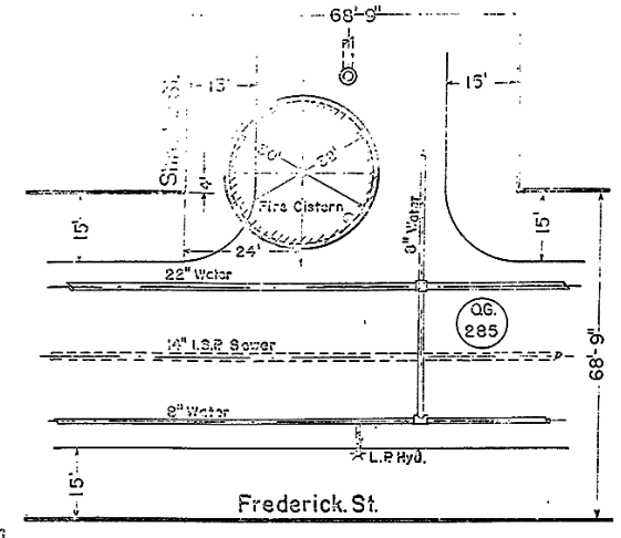
CVA asks the perennial question, “what’s up with the circular brick patterns in the middle of San Francisco streets?” Here’s the geometry of mystery at Frederick & Shrader:

and 13th & Folsom:

“My curiosity was piqued. What do they mean? Why are they there? Are they the remnants of an ancient civilization, a decorative flare from a bygone era of well funded city government, or simply the remains of an old cobblestone street?”
CVA quickly passed the SF history/infrastructure rite of passage and discovered they are SFFD water cisterns. But what was impressive was the route they took to get this information. They emailed the SFDPW and got a great response, including the original 1909 plans for the 75,000 gallon cistern on Frederick & Shrader:

(bonus: awesome fonts!)
The also received details on how the brick circle is to be laid in a bed of supporting concrete:

(For about 10 minutes I puzzled over this diagram, misreading inches for feet and interpreting it as a cross section of the entire structure. I couldn’t for the life of me figure out how the damn manhole was floating over the cistern. But I digress.)
The bricking rules are very specific (and oddly comforting):

Glad to see the partial circles are intentional.
These upgraded and reinforced cisterns were a big part of the redesign of the fire response system after 1906 — the cisterns were to be a source of water of last resort if the water mains were destroyed. They had been around since the 1850s — in fact you can see them in the 1853 and 1859 Coast Survey Maps:
1853, around Dupont & Washington:

And 1859, around Sansome & Pine.

Anyway, a warm welcome to Cole Valley Alley and their infrastructuriosity!


Heh, coulda just asked me. :) They put a bunch of new ones in in the early 90s, including one at 26th & Balboa: http://goo.gl/maps/Q1p1. I think the idea with the bricks was that they’d be obvious to find, as the one guy who knew where they all were in 1906 died in the earthquake.
Yeah, discovering their function is pretty much an SF rite of passage.
You can see them on the SF Coast Survey Maps– they are numbered in the 1853 map, and show up as concentric circles in the 1859 map.
Zoomed in clips of the 1853 and the 1859 maps.
Nice! I used to ride my bike up Shotwell for my commute and I always wondered what the circle of bricks in the intersection at 22nd was about. (http://goo.gl/V9qT1)
Back in the days before I knew they were cisterns, I used to suspect that they were abandoned turntables for old streetcar lines.
Over the past few years, I’ve been slowly compiling a comprehensive list of all the underground cisterns in SF that are marked by these brick circles. (There are lots of them that aren’t marked by the circles.) I think I have about 30 of them. I have them all marked in a Google Earth map, but I’d like to put them on Wikipedia somehow. I tried at one point to create a new page, but that seems to be next to impossible now.
Yeah, GE is frustrating.
I’m hoping to develop some geo-database with some other folks to track things like this. Very very early (ie back of napkin) but hope to have something in a few months, will ping you.
I have a domain, http://sfgeo.org , that I planned to contribute to some effort like this as well, some sort of repository and sharing mechanism for geospatial data, human and physical geographic data, geology, everything our wives/husbands love hearing us ramble about. Right now it points to some Eric Fischer geodata donations from the mensis mirabilis of May-June 2010.
There is a working example of what could be the core of a data sharing mechanism up here:
http://sfgeo.couchone.com/_utils/database.html?contrib
Anybody reading this can go to that site and hit “new document”, pick a title, then “upload attachment” and whammo, instant geospatial data sharing community. The database system is called CouchDB and you can also access it directly via HTTP, this may be a good use case and it is a pleasure to use. You can also set up a free database account at couchone.
Aidan if you have some kmz files or pdfs of scanned notes or anything at all you don’t mind sharing, by all means upload whatever you like.
Thanks for the shout out! LOVE your blog.
Added clips of the 1853 and 1859 Coast Survey maps to the article, along with the sfmuseum.org article on the post-1906 redesign of the firefighting water system.
Cisterns rock. Awesome clips, too. (The fonts are cool, and peep the signature!) Yay for infrastructuriosity AND that sweet neologism.
I used to imagine there were creatures living in there when I was a kid. I guess it never occurred to me that the significance of the brick patterns you see above ground wouldn’t be totally obvious to a passerby, but I guess it’s not a Normal Thing for people that grew up elsewhere… This happened a lot to me in my youth: slowly coming to the realization that the rest of the world is not like San Francisco. Like, doesn’t everyone have gold fire hydrants to mark the special functioning-in-an-earthquake one? And the earthquake drills and kits at school, etc, etc. Someone recently discovered I’d never mowed a lawn or shoveled snow, so I guess it works both ways.
My absolute favorite cistern is at 28th and Diamond… But, hmm… floating manhole covers. This I have to look into.
Thanks as yooj!
Wow! I’ve known they what they were for years, however I always thought that they were part of the rejiggering of the fire-fighting water supply POST-1906, I never realized that they ante-dated the quake/fire!
The cistern at 22nd and Shotwell is also notable as it is was one of
The cistern at 22nd and Shotwell is also notable as it was one of the KEY water sources used to stop the fire in the Mission District following the 1906 Earthquake. The “Golden Fire Hydrant” at the corner of 20th and Church usually gets all the glory for this (and it definitely was an important part of the effort), but if you look at the reports of the SF Fire Department issued after the disaster, again and again the cistern at 22nd and Shotwell is mentioned, as is a cistern located on 19th between Shotwell and Folsom.
Oh yeah, I’ve got an epic post in the works about those Shotwell cisterns (once I figure out better mapping options…)
It’s easy to find these, even ones not marked by a circle of bricks: Any time you see a fire hydrant with a green top, that means a cistern is beside it, though not connected to it. Joints break in a quake. So, you have to use a bucket and rope or a pump and hose to retrieve the water from the lid usually marked CISTERN.
I’ve got a bike tour of the cisterns and a few other water sources coming up as part of my Thinkwalks.
Oh, classic. I leave town for a few months and all the cool kids back home get to go on cistern tours. :-) Sounds awesome, eh.
They shut off our water here yesterday for a few hours due to high turbidity levels caused by a storm. (Apparently this is a regular thing; I keep meaning to take a picture of the very amusing sign up in the elevator about this…)
Cool. For decades I have lived a mere 90 miles from San Francisco, yet my knowledge of The City is limited. Burrito Justice has motivated to learn more. The city in which I reside has preserved almost none of its history.
wow, we both decided to research these within a two week period!
http://calibersf.com/2011/03/08/what-are-those-brick-circles-in-sf-streets/
You guys have better research skillz.
But you all have better photo skillz. I’d just hack some crappy panorama together.
Hi great readding your post