SF+200′ sea level rise
June 7, 2072 (AP), Northern California Association of City States:
The NCCS (Northern California Coast Survey) has updated their baseline topographic map of the San Francisco Archipelago. It reflects the new coastline resulting from the unexpectedly rapid disintegration of the East Antarctic ice sheet and sea levels finally hitting the 200′ mark (compared to the 2012 datum).

This poster, designed by centenarians Brian Stokle and Burrito Justice, is available in three sizes (note: adjusted to 2012 dollars, and old-style American measurements – please double-blink to convert).
(Note: default shipping is via 12 hour pneumatic tube from Zazzle’s underwater Redwood City printing facility.)
Detail:

Note this should not be used for navigational, construction or underwater recovery purposes. The street map, previously delayed due to budget restrictions due to the construction of the new Norcal Capitol building on the Fresno shoreline, is now available:
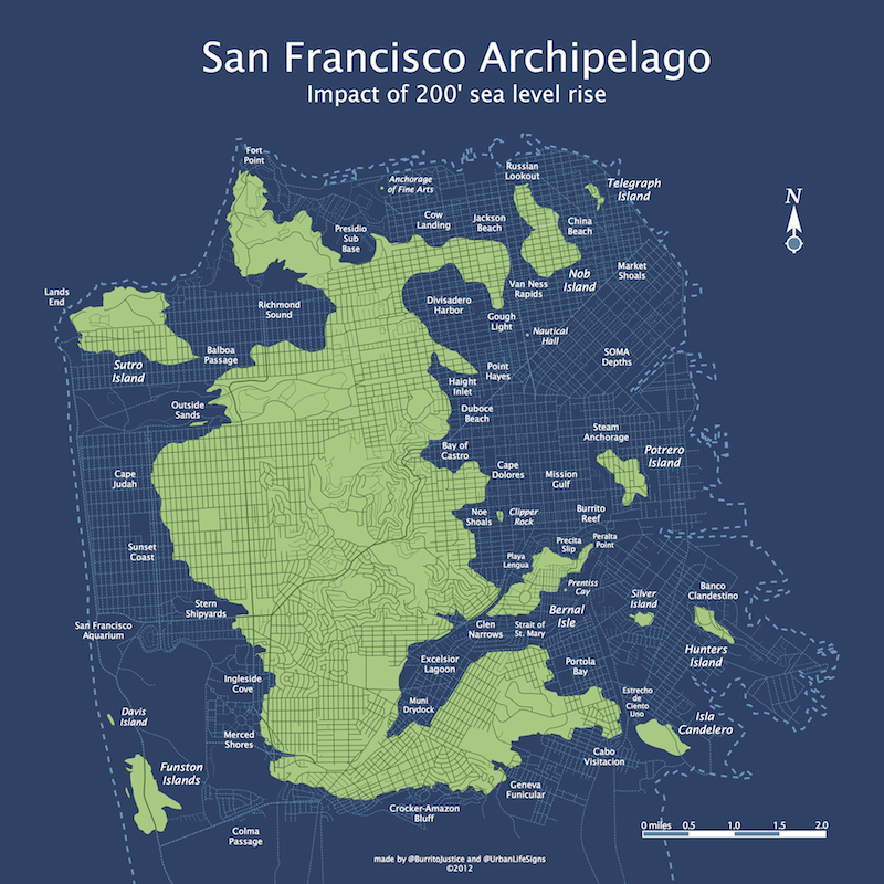
Detail:

It is available in the following two-dimensional poster form factors from Zazzle:
All these prints are also available in a pseudo three-dimensional stretched canvas print.
This week’s headlines in SFCurbistGate:
- Given their role in maintaining emergency transportation during Meltwater Pulse 3A, it was surprising that taco boats were ever restricted. Thankfully a liberalized permit system is expected to be in place by the end of hurricane season.
- Noe Shoals residents vow to stop any port in their area bigger than a 40 boat small boat/fisherman fleet marina.
- Bernal Isle residents bemoan the design of the Cortland-Chernery street bridge, and worry that the influx of new visitors will threaten the “unique” character of the island.
- Debate over where to build new container port continues — Geneva/Muni Yards or Divisidero Harbor?
- Lawsuits continue over the ill-conceived levelling of San Bruno Mountain to 150′ in 2045.
- The Board of Supervisors agreed to extend Twitter’s tax break if they build their new 110 storey corporate headquarters on the disadvantaged Nob Island.
- Sea trials of the NCSS Ed Lee continue out of the Presidio Sub Base. The first of the Sutro-class algae-diesel attack subs is expected to contain the southern incursions of the Vancouver Island-Cascadia Alliance and neutralize the Orange County drone fleet to Port Fullerton.
- The bond measure for a new multipurpose floating sports stadium anchored on Alcatraz is expected to fail in next week’s referendum. Meanwhile, the 49ers consider a move to Santa Cruz.
- A new study has revealed that the on-time statistics for Muni’s fleet of sea buses have been exaggerated since 2064 — average speed is 20 mph, not 20 knots.
More information about day to day life in the San Francisco Archipelago is available in the March 2072 issue of The Rise of Sea Levels & Burritos.
Trackbacks
- The Streets of Submerged San Francisco « Burrito Justice
- Bernal Isle Resort: A Modest Proposal for the Future of Bernal Heights | Bernalwood
- Pacific Northwest Boating News: Seattle is the new San Juans | Three Sheets Northwest
- Islands of Seattle » lolwithtims blog
- Skeletons Beneath Our Feet | Burrito Justice
- Islands of Portland | Spatialities
- Bay of LA | Spatialities
- Mapping the Proposed Balkanization of the State California | Musings on Maps
- Sea of San Diego | Spatialities
- Vancouver Archipelago | Spatialities
- SPUR Urban Cartography Exhibit | Burrito Justice
- When plates and people move | Peter Pan lives here
- Here Comes The Flood | Burrito Justice
- Palm Springs Bay | Spatialities
- Montreal Archipelago | Spatialities
- Global Melting
- This Is What Your City Would Look Like If All The World’s Ice Sheets Melt | techblog
- What the West Coast would look like under 260 feet of sea level rise - The Washington Post
- These fantastic maps showed us different worlds in 2014 | Grist
- These fantastic maps showed us different worlds in 2014 | limitless life
- The NY Sea | Spatialities
- Montreal Archipelago | Spatialities | Enjeux énergies et environnement
- New York Times Exposes La Lengua’s Diabolical Climate Change Hoax | Bernalwood
- In the News 26.04.17 : Today’s Articles of Interest from Around the Internets :: This Is Glamorous
- Our Climate Future Is Actually Our Climate Present – NewTimesAlways
- DQ: Jeffrey Jerome Cohen, “Noah’s Arkive” – Bad Collections
- Seattle is the new San Juans | Three Sheets Northwest
- Sea of San Diego – Conspiracy of Cartographers
- The NY Sea – Conspiracy of Cartographers
- Vancouver Archipelago – Conspiracy of Cartographers
- Updated Portland Map – Conspiracy of Cartographers
- Montreal Archipelago – Conspiracy of Cartographers
- Palm Springs Bay – Conspiracy of Cartographers
- Bay of LA – Conspiracy of Cartographers
- Islands of Portland – Conspiracy of Cartographers
- From “Wet End” to “Coquitlam Island”: New map shows the future of sea-level rise in BC | Canada News & Travel


Any chance I can have permission to use this ab fab map on a flyer for a (free) talk I’m giving in San Mateo on sea level rise next month? Thanks for letting me know!
Super!
Steam Anchorage is my favorite! (A reference to the Anchor Steam Brewery on De Haro and Mariposa I assume?) Sneaky!
At least bits of San Francisco will survive. Here in NYC, except for Grimes Hill in Staten Island and Washington Heights in Manhattan, most of NYC (with the exception of the upper Bronx) will be totally gone. That includes all of Long Island…
Great bllog post