LA Station Fire – Mt Wilson Webcam Timelapse
Our friends down in LA are not having a good day. The Station forest fire is approaching the 105-year old Mt. Wilson Observatory along with the dozens of TV and radio antennas on the mountains that overlook the city. (As of 11:45 it was within half a mile.)
The observatory webcam happens to point towards the fire approaching from the west. It takes a shot about every two minutes — here’s a version I made with about three hours of shots (around 70 frames) compressed into 6 seconds. You can see three fires progressing along the hills, one on the right, one on the left, and one in the center that flares up towards the end of the timelapse. (Best to watch it in HD mode on Vimeo itself.)
(If the Vimeo link is borked for some reason, here’s a ridiculously large (30 MB) animated GIF.)
There’s a lot of smoke and it’s hard to tell what’s where. I just found this timelapse of Saturday sunset (via Sky & Telescope) that helps with perspective.

Here’s quick and dirty blink comparison of Saturday and Sunday which better shows the location of the center fire (I’m guessing the flare at the end is the fire creeping around that tall peak):

Google terrain map:

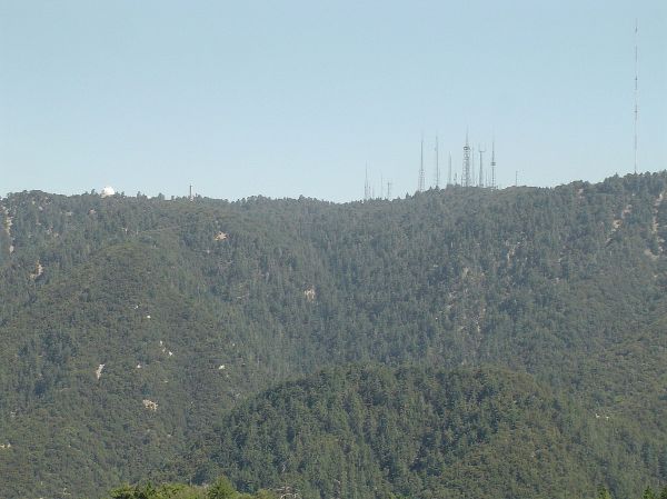
And here’s the ridgeline, from what I believe is the north. The observatory is on the left, and the tall tower with 4 red lights in the webcam shot is the one to the right. (To give you an idea of the foreshorening in the webcam shot, it’s about the same height as Sutro Tower.)
The next time you complain about fog in San Francisco, consider this rather terrifying panorama of the fires in the San Gabriel Mountains above JPL in Pasadena (via The Planetary Society and Leticia Montanez).


My bf is giving me grief for paying too much attention to that fire, but its a doozy. Judging by the LA times perimeter map, you could overlay it east to west and it would stretch from Santa Monica to Hollywood. Yikes.