A Brief GIF History of Army Street (and Clooney’s)
By this point anyone who reads this blog has seen the excellent detective work by Bernalwood and Associates on the mystery of the oddly angled apartment on Cesar Chavez:

The esteemed Jonathan Lammers, architechælogist, used the 1938 Aerial Survey of SF to make a giant conceptual leap. The building was moved from across the freakin’ street as so lovingly diagrammed by Bernalwood:

I mean, let’s just stop and look at that diagram for a minute. That is a thing of absolute beauty. And I shall ruin it via GIF! (click to animate). It’s shocking how far back they moved the northern side of Army (click for a slightly wider version).

Given our angular building was only built in 1927 and they widened Army in the 1940s, it makes a lot more sense that it was moved. The two buildings towards the point of the triangle (3390-3398 Army) were considerably older at the time, never mind much smaller, so I suspect they were not considered worth the effort.
As for the old address of the pre-rotated and translated 3365 Cesar Chavez, I believe it is 3370 Army. I have references to 3380 Army being torn down in the 1940s, and a significant number of people are listed as living in 3370 Army in the Polk Crocker-Langely city directories of the 1930s.
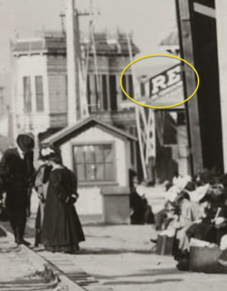
You can see 3398 Army (the one on the right, with the nice round cupola and double doors) in the SFPL archive (looking north on Mission, across Army St.)

Side note: that Redlick-Newman sign is by the same guys who did the 17 Reasons sign!
While I couldn’t find any specific dates or pictures of the widening of Army around Mission, I did find another picture of work on Army on what I think is between Guerrero and Valencia, dated 1949 (via eBay…) Pretty sure this is taken near Guerrero and Army, looking east towards Valencia.

I think you see the top of the Sears Building by the trees.)
It’s pretty much the opposite view of this one (via this older post):

and this one from 1946 via SFPL — you can see the white buildings in the top shot:

I was looking for other highly acute buildings in the Mission to see if our other friends along Army were moved elsewhere, as was Bernalwood reader Joseph:
Could it be that the trapezoidal building on the corner is now clooney’s pub on valencia? i’m not a scientician but it looks like it to me.
…
OK I’m totally wrong that building is still there and it’s the palace steak house. do smarter people than me know what the deal it with the clooney’s building??

I’d always assumed the angu-tacular Clooney’s was associated with the old Southern Pacific Railway that used to pass through the neighborhood.But upon further research, this is utterly incorrect!
The old SPRR station was on the west side of Valencia — behold another explanatory GIF:

Here’s an overlay of the 1915 Sanborn map that shows the station:

It turns out the turn of the century (19th, that is) predecessor to Clooney’s was a place called O’Reilly’s. You can just barely see the building here in this 1906 photo (via Calisphere) of earthquake survivors gathering around the Valencia St train station, on the right.

If you zoom and enhance, you can actually see what we think is O’Reilly’s sign starting with O’RE… (hat tip to Bernalwood reader WJE).
This is a very different building that today’s Clooney’s — and there’s a possibility that the angular building was dumped ON TOP of O’Reillys.
It turns out that Urbane Libertines and Atrocious Saints is working up a detailed history of Clooney’s, and published the first part just a month ago! Lots of legwork resulting in some epic finds. Lots on the O’Reillys, and their patrons too!
In 1906, shit got real. Not only was San Francisco in the grips of post-earthquake trauma (O’Reilly got his liquor license restored in June), but the railroad depot for the Southen Pacific railroad line was located right across the street from O’Reilly’s saloon, bringing a variety of people down Valencia on the streetcar and from the SP depot at Townsend and 4th. The line cut diagonal across the intersection (coming from what’s now the Synergy School and through the ugly (sorry!) building housing the chiropractic clinic (an oasis amidst the ugly angles) and the Siron Norris gallery (also an oasis, dude).
One night in 1906, a patron was drinking at O’Reilly’s, waiting for his train to head home to Redwood City. Reports go that he had gotten paid for a job on Howard Street earlier that afternoon and had made his way from saloon to saloon, eventually perching himself on the (I’m only imagining) fine-grain walnut stool to drink some spirits with ol’ Jeremiah. Around 2 in the morning (guess he missed his train?), two patrons lured the carpenter outside under the pretense of getting him a hotel, and then on Bartlett street, savagely attacked him, lacerating his face and breaking his shoulder. He limped to nearby Bethany church and got help there. Sounds kind of like Clooney’s right now, minus the train to Redwood City.
It is an epic read, and apparently there is a part two on the way (which covers how the apartments got on top in 1934…)
But more importantly, in 1904, the SF Call tells us that O’Reilly had the misfortune to got robbed by the “worst burglars that have infested the Mission district” — which happened to be two 12 year olds.)

And we will conclude on an inflationary note — in 1904, you could buy two revolvers and ammunition for about $6.80, equivalent to $167 dollars today. Also, “Rimmer & Railton” (hey, free band name) were able to buy revolvers in San Mateo. As 12 year olds.
Findery trackbacks:
https://findery.com/burritojustice/notes/move-an-apartment-building-across-the-street
https://findery.com/burritojustice/notes/a-train-station-and-a-bar


Another interesting thing I learned from the 1904 article: Bars were apparently closed on Election day! Or, at least, O’Reilly’s was, and it seemed to be something natural/expected from the way the author phrases it.
Imagine that, people taking their civic duties seriously!
It’s because bribing people with booze was a known campaign tactic on voting day!
As far as moving that house across army street, that’s extremely impressive, especially considering the fact that they only had the width of the street to turn it around in. Looking at the overhead photos, that must have been pretty close thing.
If you want to have even more fun with this, you’ll note that the Sanborn map shows Orange Alley between 25th and 26th was home to a very large concentration of stables–including a large stable behind what is today Clooney’s. Thus we end up with this.
While we’re on the subject of bars, history, and Army St, does anybody know anything about the ghost bar at 1480 Alabama, on the NW corner with Cesar Chavez? If you look in the window, you can see all the bar stuff, including stools, still there, but it’s clearly been closed a long time. From a little online searching, I learned it was once called Pete’s Corner…
I am totally going bananas over this. I have stared holes into that photograph so many times, but never, EVER has the “ORE” on the sign jumped out at me like that. Eagle-eyed history detectives!
But, a sliver of me is not convinced that that is an O’Reilly’s sign. It probably is, but something about the angle of this photograph has always bothered me in terms of trying to match it up to the aerial understanding of all of the buildings along the ROW. Particularly, behind the O, isn’t that lattice-looking thing ostensibly the arm of a crossing gate (am I fooling myself? Did we have crossing gates then? More research!). But if you imagine that arm coming down, it would look to be coming down across 25th, not across Valencia, but the photographer is not standing on 25th, he (OR SHE) is standing in what is now Green Chiro clinic looking northeast, right? I’m probably missing something (plus I have the eyesight of my optician’s “elderly patients,” direct quote) and also probably in disbelief that I didn’t spot the sign!
Astounding, all of it! What a crazy discovery.
During the rainy weather over the holidays I decided to take another stab at solving the Clooney’s question. I started with the assumption that the current building was definitely moved onto the property, and that it was moved there after 1950. I also made the assumption that it was more likely to have been moved from somewhere nearby, rather than across town.
This gave me two good places to start looking. The first was along the route of the former railroad line through the Mission (abandoned in the 1940s). I thought this was most likely, because the shape of Clooney’s definitely implies that it once stood on a gore lot (or “flatiron” lot), which is exactly the kind of parcel you might expect to find along a former railroad right of way. The second was following the route of Highway 101 along the slopes of Potrero Hill and down into SOMA. I also liked this idea because a large number of buildings were relocated by highway construction, and it seemed plausible that at least one of them had stood on a gore lot.
Unfortunately, after spending several hours with David Rumsey’s 1938 maps, I couldn’t find any buildings along the railroad or freeway right-of-ways that seemed like decent candidates. The mystery continued.
Today, though, I decided to focus solely on looking for historic gore lots in the Mission. And when you look at a map, one of the areas that immediately grabs your attention is the convergence of Mission Street, San Jose Avenue, and Dolores Street (or as you would say, the heart of “La Lengua”).
I am not exaggerating in saying that I found a good candidate for Clooney’s in less than thirty seconds: an odd-shaped building on the southwest corner of San Jose Avenue and 30th Street. It had two slanted bays facing north onto 30th Street, and three slanted bays fronting the diagonal line of San Jose Avenue. The location of the light well also seemed just right. Feeling lucky, I decided to take a quick look at the SFPL historic photo collection to see if it might have an old photo of the intersection. Miraculously, it does. And there on the right hand side of the photo is what I feel certain is today the building housing Clooney’s at 1401 Valencia Street.
Obviously, the first story of the building as it appears today is quite different. But it is not hard to extrapolate that when they moved the building onto a new foundation, they left a generous setback at the street so that they could construct a one-story extension for the pub.
And why was it moved? Once again, street widening was the culprit. Comparisons of the 1938 aerial map and current views make it clear that many, many buildings were removed along the west side of San Jose Avenue. In fact, the current building standing on the southwest corner of San Jose and 30th was, in 1938, the third building west from the intersection!
Almost certainly, the street widening was done in conjunction with the construction of I-280, which opened in the late 1950s. The fact that Urbane Libertine mentions that the electric meter at Clooney’s was installed in 1951 would appear to indicate that was the year the building was moved.
Whoa! Excellent research! Thanks!
Damn! Nice work as usual. Very clever looking La Lengua-ward. I forgot I wrote about that photo & intersection a few years back on Mission Mission. 30th & San Jose is totally unrecognizable compared to today.
That is really coming full circle! In reading your old Mission Mission article I almost half expected you to mention that the building in the photo would later be moved and turned into a saloon …
Bad news — I think the angle on San Jose goes the wrong way for it to be the Clooney’s building.
Here are clips from the Sanborns for 1915 San Jose & 30th vs 1950 Clooneys (you can see the angle on top).
So damn close! (I’m notorious for flipping things around, so let me know if you disagree.)
Hmm, that’s 29th & San Jose, not 30th. let me recalculate…
Keep in mind that the building looks as though it was built in the mid-1920s, so you’d want to look at the 1950 Sanborn, not the 1915.
It gets more interesting. The March 1950 Sanborn map for 30th and San Jose (Volume 9, Sheet 904) shows what appears to be the building, although it does not include the bay windows on what was then its east facade (but they are in the photo).
The December 1950 Sanborn map shows the building in place by that time. Again, the bay windows on the secondary elevation are not shown. The building is also drawn incorrectly as having an extension to the south which is not there in reality. The conclusion is that it had only recently been moved onto the lot and the Sanborn people either surveyed it incorrectly or had incorrect copies of plans. I think the most operative comparison is still a combination of the 1938 aerial and the photo at SFPL.
Sorry to keep posting, but another thing I noticed in comparing the 1938 aerial with the 1950 Sanborn map is that you can tell people are already getting their buildings out of the way of the street widening project. The building directly west of what would become the Clooney’s building is there in 1938, but not on the 1950 Sanborn. Same goes for buildings all along the west side of San Jose Avenue moving south (at least five were removed between 1938 and 1950, including two just north of the gas station at the southern tip of the block).
In fact, it appears that everything south of what in 1950 was 1163 San Jose Avenue was completely sheared off. The building that is now at the southern tip of the block where San Jose meets Dolores was quite likely moved from elsewhere on the block and turned to face south so as to fit onto the lot.
Wow. Just wow. 1938 aerial of San Jose & 30th (rotated) vs Clooney’s today.
The photo of the intersection of San Jose Avenue and 30th Street did not post; here’s the link:

I’m doing genealogy and was flipping through an old SF city directory for 1948. My relatives used to live on “Kona Street”. I struggled to find it on google maps today. The city directory said it was near Kansas and Army. Obviously the houses were torn down due to road construction, which explains why it’s gone today. haha! Awesome!
I know I’m coming in a decade late, but this post is evergreen and good enough that it may continue to see traffic from here on. In Chicago we have a rich history of moving houses, a cottage industry that sprung up after they “up-graded” (raised) the entire city a story to get it out of the swamp. It was common to build a cottage and then later, as your family grew, move that cottage to the back of your lot and build a townhome. These remain today as mother-in-law apartments or carriage houses.
Before the utilities and the overhead wires made things difficult, moving houses became such a nuisance that in 1846 a group of Chicagoans asked that the city council not permit more than one building to stand in the streets of any block at the same time, or permit any one building to stand in the streets for more than three days. It was so common, in fact, that a tourist wrote of his visit that one day on a walk towards downtown he passed nine houses going the other direction.
When was the original wooden stairway up the hill on (then) Army Street to Holladay Avenue built?