Alternate Mission
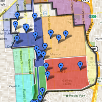
Eric Fischer uncovers a rather startling set of mid-60s plans for the what the Mission could (probably not) have been. We’re talking massive infrastructure, along the lines of Embarcadero Center, running the length of Mission from 15th to Army/Cesar Chavez. (click images for originals on Flickr)

Mission and 24th:


Note the walkways across Army/CC…

…to massive, circular parking lots.

I somehow doubt Valencia would have maintained its bicycle friendly charm.
Mission and 16th:

Hey, a kite!

Hooray, tacos!

But a piñata tent? WTF are the chairs for? To watch people break piñatas? People pay for that? I’m confused. (I’d totally dig a Lucha libra tent though.)
Some context is in order. This was the “Miracle Mile” — the Mission used to be one of the primary shopping districts in the city (there was a Sears at Mission and Army, after all — that was probably what the second walkway over Army St was for).
1956:

Pictures of shoppers on the Mile in the 40s and 50s: (from SFPL, but their image site seems to be down at the moment so I can’t link to the metadata, sorry)
1958:

1957:

1949:

I am sure theses 50s/60s era planners were hoping to stem the flight to the suburbs as the city depopulated around them.

(Anyone know how to constrain the date range for Wolfram Alpha charts?)
This is of course a completely different approach of construction destruction than the post-WWII SF freeway plans that we’ve discussed before — imagine a huge Geary-like trench through the Mission, and a highway on the west slope of Bernal, along Coleridge.

Detailed map below of the Mission Freeway from 30th to 14th (south is up). basically, all the odd-numbered streets except 21st would have been cut off, and the even-numbered streets would have been bridges (think Fillmore over Geary).

I need a drink.
Happier bonus material of a slightly modified past via Eric: a great 1966 picture of 24th and Mission (looking north):

Here’s a bunch of 1950 Sanborn maps jammed together to give you an idea of what the pre-BART 24th and Mission was like. (Click to zoom).

The NE and SW corners of the intersection are obviously gone. The McDonalds took out the SE corner, but the building next to it (Last’s Paints) is still there (now Western Dental / Mr. Pollo), as is the Dance Mission Theater building on the NW corner.
Here’s the 1950 Sanborn overlaid on Google Earth:

Note the stores in the diagonal slot where the railway used to be. Next time you have a sausage and beer at Rosamunde, remember that you are sitting right on the railway tracks.
Speaking of which, a 1926 shot of the guard arms for the active railway crossing (looking north up Mission, just before 24th) :

The rails in the foreground are the tracks for the old 14 and 24 streetcars (via SFPL)
And a 1945 shot of an apartment fire on 24th between (1) Valencia and (2) Mission (where that big church is now) from a WWII bomber that happened to be flying over the Mission:

(SFPL)
Zooming back to the 1950s and 60s version of the corner, we can get an idea of the vibrancy of the mile:

(Sorry for the lack of bars. Older Sanborn maps clearly mark bars/saloons as “Sal.” but it’s weird there are NO bars here. I’m guessing Sanborn never updated the maps to show saloons like they did before the 1920s. Still, a lot happening on the corner…)
Anyway, some great details in the photo:
Theater marquees a few blocks down the street: Grand. Crown. New Mission. Tower. Also the Leeds / Sketchers sign. No trees at all.

Tired of your typical, depressing 1960s bar? Sobered by highway and infrastructure planning? Come get a drink at “Smile Awhile Cocktails!”

Hey, that sign sure is a funny shape. Jigjag, jigjag. Just north of 24th. Where have I seen that before?

El Farolito, continuing the tradition of old school Mission signs.
And this concludes today’s lesson in Mission bar and infrastructure history.
Trackbacks
- Indignant Desert Birds » Sunday Morning Reading Material (Third Sunday in September)
- Good Morning Mission! – Mission Loc@l -- San Francisco Mission District's News, Food, Art and Events
- ’62 Mission, Proto-Farolito « Mission Mission
- College Hill and East Side, Providence, R.I., 1875 vs. 2011 | the weblog of robin camille davis
- Wide, Wide, Bernal and Capp « Burrito Justice
- Miracle Mile, 1954 Style « Burrito Justice
- Announcing the Pastmapper app for iOS | Pastmapper Blog
- When All Else Fails, There is El Farolito - SF Weekly


you, sir, are a raging genius. thank you.
It’s all Eric’s fault!
Thanks for all the additional map and photo research! What a strange and unwelcoming place the future of the past was.
Great post, man.
Oh man, that is amazing. There but for the Grace of God, etc. Scary to think that the Mission could have gone the way of the Fillmore/Embarcadero.
It’s worth noting too, that those plans would have had a much greater chance of occurring had not it not been for the intense and steady organizing in the community, including especially the Mission Tenants Union and eventually the Mission Coalition Organization. It led to Model Cities Money pouring in and a whole community planning process that more or less stopped Redevelopment in the Mission… but it’s happening now more stealthily!
anyway, thanks as always to Eric and El Doctor de la Lengua… awesome!
The more I read, the more I also want to credit Allan Jacobs and the Planning Department from the era when he was Director with saving San Francisco. It was his department that totally rewrote the car- and demolition-oriented World War II-era Master Plan into the form that more or less still stands today. They were also apparently responsible for stopping the Redevelopment Agency from bulldozing several neighborhoods by stepping in preemptively with resident-driven housing rehabilitation programs to get the neighborhoods back into shape before the Redevelopment Agency had a chance to declare that the areas were substandard and had to be demolished.
Thank goodness we didn’t get pedestrian bridges over Chavez!
Mike Miller was one of the organizers of the Mission Coalition. He still lives in (what is now) Noe and wrote a book about the Model Cities/Mission Coalition era:
http://www.heydaybooks.com/history/a-community-organizers-tale-pe.html
Added a few more pictures of the intersection, along with links to the post WWII Mission Freeway plans.
Rosamunde is *on* the railroad tracks. (Google Maps has its business labels wrong).
Thank, fixed it — that’s what I thought but the Google business name threw me off.
Well, I have to say… I love the Embarcadero center. I really like the idea that cars and pedestrians are separated on different elevation levels.
As for 24th Street BART… That corner really could use some work, and adding taller mixed-use buildings could work.
I especially love the photo showing the New Mission, the Crown and the Grand. Spent way too many weekend hours inside those theaters. Walked down Mission the other day for the first imte in many years. The change between then and now was staggering. I’m still reeling..
24th & Mission on a Thursday Afternoon
The street was filled with the busy heat
And salty tang of the life in the Barrio
Everywhere there was the quick exchange
Of cash for goods transacted under tables
And gaudy carts strung along the sidewalk
Before rows of empty storefronts and lots
Where I once spent my Saturday afternoons
There was chili in the air, the odor of cilantro
And lemon on the corner of 24th St. station
A man sitting on the stairs by BART is selling
Giant avocados from twin Safeway bags
He halves them adroitly with a Buck knife then
Put pitted halves in paper bowls, fills the pits
With red salsa, serves with spoon and napkin
SPMackin, August 2011
Thank you for posting. Can’t imagine the changes you see.
If you had any pictures from your movie theater days I would love to see (and post) them. Any stories too!
And here is more about the train line that used to cross Mission near 24th, from a piece I wrote for the SPUR magazine: http://www.spur.org/blog/2010-06-30/urban_field_notes_six_spots_mission_track_traces_trains