Wide, Wide, Bernal and Capp
Longtime readers know that map scanologist Eric Fisher is a wonderful source of early 20th century constructo/destructo-porn. While many plans did not happen (a skytrain down Valencia St, for example, or an elevated Capp St Railway, or the Mission Freeway, or a Mission corridor from 16th to 24th the likes of Embarcadero Center), some did.
Here we have a map revealing 1924’s “contemplated projects” – Mission detail shown below, click the map to see the entire city.

Unlike the blight-driven plans of neighborhood-splitting projects like the Mission Freeway, it seems many of these came to pass. (Oh, people from the 1920s, your city planning is so quaint compared to the dreams of your children.) Two things stand out on this map:
1) Capp St extension — it was to be a backup artery to Mission St. While it never hooked up to Van Ness, it did get slightly widened.
Here’s a 1939 shot of Capp and 25th from our friends at the SFPL.

and today via MapJack:

Other than the tree and the curb very little has changed.
Here’s 23rd and Capp under construction in 1940:

And today:

Alas this widening did not stop folks from moving down to the Peninsula.
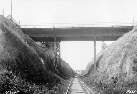
2) The widening of the Bernal Cut certainly happened.
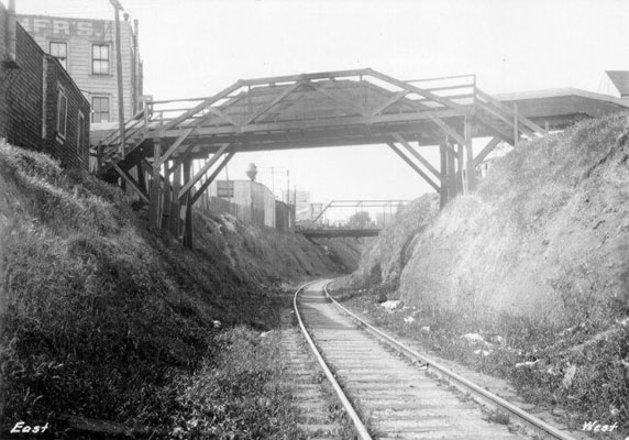
A very narrow Bernal Cut was originally dug out for the San Francisco San Jose Railway in the 1850s. Here is the Southern Pacific train in the cut, “looking north near Milton St”. Think of this while you take the San Jose exit off 280.

And “looking south near Charles St.”

(You really ought to buy the Arcadia Press Bernal Heights book — our friends at the Bernal History Project did some fine work on that one – lots of incredible pictures, especially one of the Cut that is simply amazing.)
Anyway, Charles and Milton are way the hell apart but it sure looks like the same house and tree up on the top of the cut. Could it have been the house at Mateo and Arlington? 1899 map below.

The there is the mystery of Charles St. A Twitter conversation arose on what happened to the 0-100 block of Charles St got me curious. I originally thought they widened the cut mostly to the east. The eastern-most block of Charles St also got lost in the widening, but Eric Fischer let me know that they moved Arlington as well on the west side of the cut.
Anyway, here is our vanished bridge across the cut at Charles street:
and a water main that crossed at Fairmount over to Appleton (I imagine from the Holly Park reservoir?)
(This was the weird looking one you can see in all the construction photos.)
Out of sheer amusement for making map 1000 pixels long, here are a bunch of the 1899/1900 Sanborn maps I glued together showing the cut. (The 1886 maps don’t show all of it.) You can see the two bridges quite easily.

As we all know from the San Jose exit off 280, the cut is rather larger now than the train pictures above.
Here’s a shot from Jan 1929 with the widening of the cut is well underway. This is at Bosworth (hint: you know you are in a depression when people are pushing mud around).

And later that year we see pretty much what we have today. The Richland (foreground) and Highland Street bridges, Oct 1929. (Taken at about the same place as the first train shot above).

Same view today:

I’m guessing they took out the two center supports and put those wonky braces up in the 50s when they shut down the Union Pacific rail line? (Muni didn’t run through Balboa until 1991.)
See more before/after San Jose time magick over at Bernalwood. And I just found this interesting before/after comparison video of the Cut on YouTube:
and the same person put up this rather remarkable then & now of a house in Glen Park. But I digress.
Here’s a shot from the Richland bridge in 1942 looking south towards St. Mary’s and Mateo @ Arlington. Interesting that the railroad tracks are on the inner edge of the curve, and San Jose on the outer part.

Notice the landslides on both sides of the road — that’s why we have those tall concrete walls today.


That’s terrific! What are those amazing fortress-like stone towers in: https://burritojustice.files.wordpress.com/2009/10/1929-bernal-cut-widening-bosworth-aaa-9909.jpg
That was great! Thanks! Also, the proposed projects map makes me want to learn more about this mysterious Glen Park Reservoir….
I think the stone towers are the ends of the pre-widening Bosworth Undercrossing (http://sflib1.sfpl.org:82/record=b1004978~S0)
I don’t think the bridges were actually rebuilt to give a single clear span until the 1970s. In the 1968 aerial at historic-aerials.com you can still see the soutbound lanes splitting around the bridge supports, but by 1980 they no longer did.
Those wonky braces on the Richland and Highland bridges have always struck me as some kind of earthquake retrofit…
I like to think that the “Bernal Cut” is also a hairstyle that you can ask for at Abner’s Barber Shop at Mission and Virginia!
hi Burrito! This is fantastic. I am working on a post for SFGate about Bernal… if I can make it fit I would like to borrow and link to some of this stuff since you have already done such a thorough investigation. I will link back and send you traffic and all the other silly pay back old media offers. Let me know if this sits well with you first though.
Anna
SF Gate
On the Block
Please do!
I am also intrigued by this “Glen Park Reservoir”. It seems to be right about at Haas Park or maybe where the fire station is up in Diamond Heights. It’s a big dot, though, so maybe it’s closer to the Canyon? Surely not as far as Christopher Park near Safeway? I don’t think there are reservoirs up there, but I could be wrong. (People say it happens all the time…)
Great post! Merci comme d’habitude.
The reservoir was never actually built, but it’s an interesting question where it would have been.
References that still remain to the “Reservoir Lands” on city records seem to refer only to the strip of undeveloped land on the west side of O’Shaughnessy, but that slope doesn’t make any sense as a reservoir site, so that must have just been the western edge of it.
Maybe the best source is the DPW base map behind the 1928 Major Streets plan. If you zoom in, you can see most of the outline of the “Proposed Glen Park Reservoir,” extending from approximately Arbor Street on the south to Valley Street on the north, with the top bulging from around today’s Grand View on the east to around O’Shaughnessy on the west. So it would have encompassed most of today’s Glen Park canyon but would have missed the Christopher playground. Given these bounds it’s kind of odd that today’s Reservoir Lands extend as far north as they do.
@Eric Fischer: Sweet links (as usual). Reservoir Lands of 310,147 sq. feet and in that location is just the kind of craziness I love.
The DPW map is pretty awesome! Good deciphering; whoever wrote O’Shaughnessy Blvd over the “…posed Glen Park …oir” was rather rude. Didn’t they know we needed this 70 years later? Yeah, it looks like they basically wanted to get all Three Gorges on us and fill in the Canyon. (Hey, if it worked in Hetch-Hetchy…)
I tipped off my history-nerd-but-not-quite-obsessive-enough-to-hang-out-with-me-on-comment-forums bro and he suggested that plan might have eventually turned into the Stanford Heights 10-013 Dam. Long, ugly link: http://maps.google.com/maps/ms?authuser=0&vps=2&jsv=351a&gl=us&ie=UTF8&hl=en&oe=UTF8&msa=0&msid=217325964311207765438.0004a6b4f74c8a8a8da98 That Google map also shows an area called “Reservoir Lands Glen Park” precisely where you mention. And since Google is always right and it’s impossible to get things added to it, like a tongue-related microhood name, that’s something, too. :-P
I just realized you can see the proposed reservoir a little better in the 1940s postal zones map, although somebody has still drawn on top of part of it. Maybe it’s possible to piece together an uninterrupted map of the park from fragments of other maps. That map also shows the Stanford Heights reservoir already in place, so I don’t think it was strictly a replacement for the Glen Park one.
Oh, and actually you can see it all without interruption in the 1935 Rapid Transit proposal map.
That one also has an intriguing difference in O’Shaughnessy Boulevard, where the bottom of it looks like it follows today’s Malta Drive and connects to Stillings instead of Bosworth. I wonder when that changed.
Sheesh, Google Maps also now shows a “Bosworth Street Future Widening” park? Somebody must have done a mass import of names for weird little scraps of land.
Speaking of old reservoirs in that part of town… Wasn’t the current CCSF parking lot originally a huge reservoir?
Huh. Apparently it technically still *IS* a reservoir, though as far as I can tell it has never actually had water in it.
Re: postal zones map: I dig how the printer’s name is Rude! More obvious about the proposal’s location, too. As an aside, I LOVE how Day Street (where I grew up) goes up several more blocks than it’s really physically possible to.
Re: rapid transit map: Very clear borders, but what a crazy idea of a location. I’ll have to think about that next time I’m home and walking my dog in the proposed reservoir.
You must have better eyes than I do, since I can’t quite parse out what’s happening at the bottom of O’S.
Re: Weird little scraps of land: Funky information! Confusion! Rebellion!