Capp Street On High
Eric Fischer brings us scans of a 1930 plans for an elevated rapid transit line through the Mission running above Capp St.
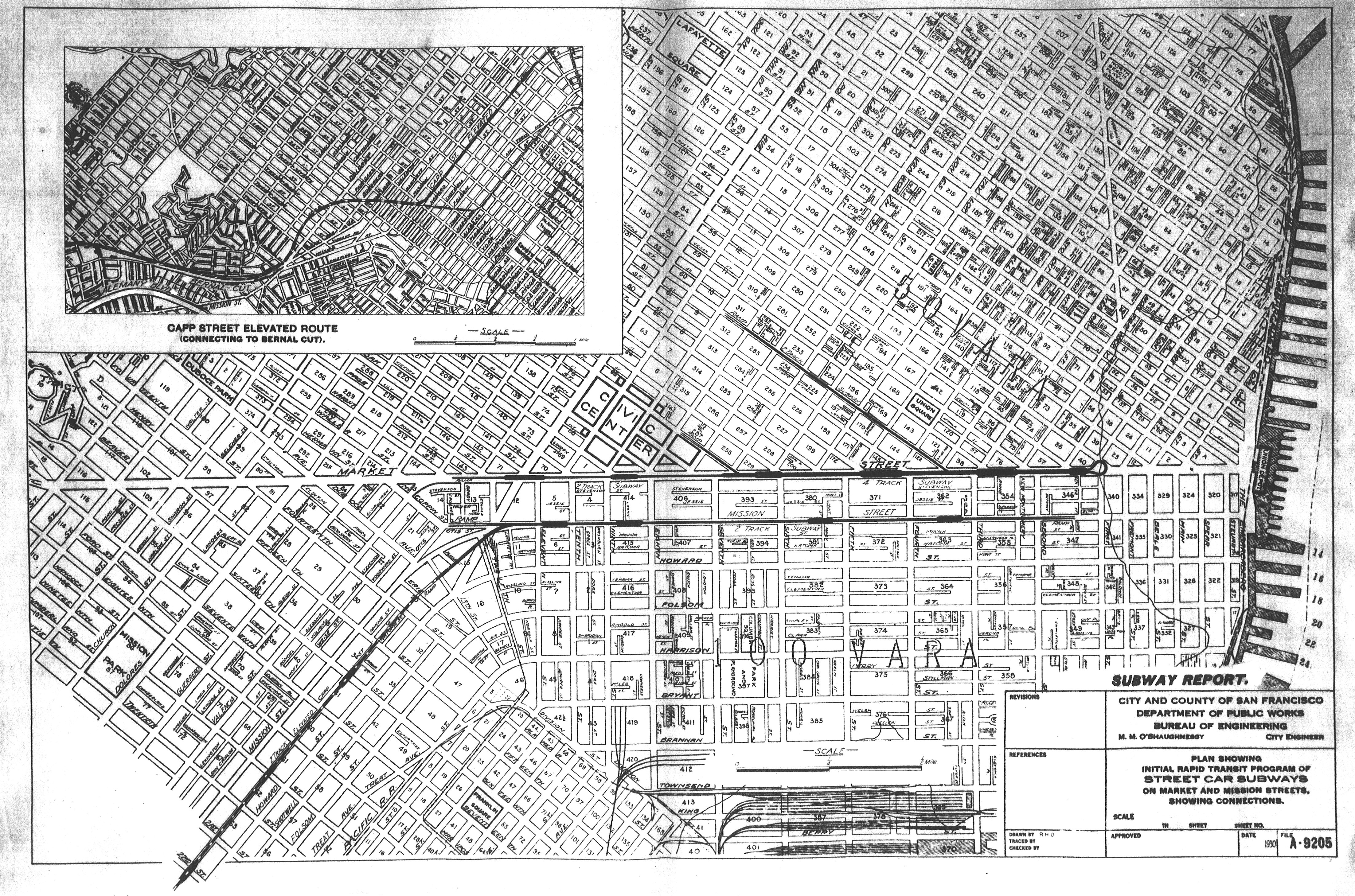
The line would also have gone above Mission St downtown, and would have continued along the Southern Pacific rail spur through Noe through the Bernal Cut to Daly city.
This looks to be a part of a larger plan with rather extensive rapid transit, also scanned by Eric, with both subways (thick solid lines ) and elevated (thick dashed lines). I took the liberty of highlighting the interesting suggested routes. Sorry about the teal and magenta, but 1930 optimism caused me to run out of colors. (The thinner black lines are streetcars.) Click to zoom, and lots of interesting details on the full sized version (including a downtown train station on 7th and a proposed highway along what’s now 280 in Daly City).
![]()
I especially like the green line running along 17th St, and of course the century-long tease of a Geary line. (Sadly no sign of my favorite idea, the Fillmore / Castro / Noe / 29th line… And you’d think a line under California/Sacramento would be appealing, no?)
Of course, the downside to the Capp line would have been a looming 25 foot hulk over our heads:


Another minor issue would have been its 300 foot right of way (yes, 100 yards, as in a football field). Streetcars underneath, and roads on the side. (Click to zoom.)

This basically would have taken out all the buildings facing Capp, with the backs of those on Mission and South Van Ness facing new Cappistan.

So say we had our Elevated Capp Line. There are several alternate histories possible here:
a) After a few decades of decay in the 60s and 70s, it would have been torn down in the 80s (a la the Boston Orange line):

(Image via AloneArt)
Given what we did with Embarcadero and Hayes Valley, we’d probably have built a nice park.
2) It would have become a beloved part of the city and hundreds of Japanese noodle shops (a la Shimbashi station) would have opened up under the arches, giving us the udon, soba, katsu and okonomiyaki we so richly deserve.

(Image via Luke Robinson/Flickr.)


Or it would have become the largest permanent homeless encampment in the US!
I hate to say it, but sadly, that seems the most likely.
And/or lots of covered parking. All the more reason to stuff the arches full of udon right away.
Sorry about the lack of narrative… the report was basically all cost estimates and maps, with hardly any text to explain what they were thinking.
The Capp Street widening plan is the descendant of one of the boulevards in the Burnham Plan, where it (instead of the former Howard) was envisioned as the southern extension of Van Ness.
I’m pretty sure the reason you never see California, Fillmore, or Castro proposed as the site of a subway is the hills. These subways were all planned to be accessed by stairs, not escalators, so deep tunnels would have been inconvenient to use as well as difficult to build/
I’m glad there is no elevated train, or loved shops under the train, or homeless encampments, or a greenbelt (oh wait, that might had been good.) We are lucky that folks in the early ’60’s fought against development of this sort. (Save the bay too) One commenter was bitching about the Victorians on an allied site. Dood should think it through a bit. The whole city could have ended up like the Fillmore or Valencia Gardens, with large swaths of “derelict houses” cleared for some idiotic Robert Moses/ Corbusier futuro vision (Valencia Gardens was heralded as a modern exemplar! )
BART is a great asset. But think hard about the architecture, especially at 24th and Civic Center. It’s stupid, on practical grounds. How do the elevators relate to the ticket machines? How do the ticket machines relate to folk’s circulation? Why are escalators exposed to the weather? Why do the stairs become rain soaked and dangerous? Why is the entrance footprint so large? And then think of the aesthetic. There is nothing really you can grab a hold of. BART is futuristic but butt ugly. Materials are used poorly, (although I like the bubbles at Powell) Spaces are ill-defined. Grandeur is hinted at with marble but comes off looking expensive without purpose.
I go on and on becuase that could had been our present. With surface structures built the same way. It would have been oppressive
Great post, great comments. My heart went pitter-patter when you said “Bernal Cut”. I walk it so much with the dog and just find myself making up stories of its history. One of these days I’ll get around to doing the research. I have seen that there are some great images available of the Bernal Cut available through the library.
Really, I do deserve more katsu and okonomiyaki.
Love this post, as I do all retro-futurist posts (ok, all Burrito Justice posts). I’m also a perverse fan of the Burnham plan, which David Rumsey’s site offers in great detail. If only every civic problem could be solved by a diagonal boulevard or a broad parkway. And I guess that would mean demolishing all manner of buildings. Including the Dolores Park Cafe. Their coffee didn’t make the cut.
Maps of Capp Street contain this article. This street is very old and now the look of this street is very unique and so many difference than old street which is big proof of the development of city. I have read full history of this street at q2bftj.com and everyone must read that history to have all information about it.