36 Views of Mount Bernal
Bats, Bernal photographer extraordinaire, brings us another in his dramatic “know your cherted hill” series:

133 second exposures are indeed your friends. Click for a much, much larger version, or one painted on a black velvet background.
And here’s Bat’s previous, most excellent shot of Bernal Island.

34 more to go, Bats! Maybe one day you’ll get a shot of snow on Bernal.

(Snow on the north side of Bernal, 1882, via the Bernal History Project)
Look on My Works, Ye Mighty, and Despair!
Look on my works, ye Mighty, and despair!
Shots from NASA’s Galileo space probe as it swung by the Earth and the Moon in 1992.

(May take a minute to get going – click image for a larger version. Animation by Gordan Ugarkovic, via The Planetary Society.)
Since the Mission is not actually visible in the above video, I will reuse this awesome shot of the earth rising over the horizon of the moon from Japan’s late Kaguya orbiter.
Hopefully this puts some things in perspective. That earth is beautiful, no?
Next to the space program, infrastructure (specifically water and sewer systems) is likely our civilization’s crowning achievement. (Think about it — if you only could have one, would you choose running water/sewers, or electricity?)
All of this is an excuse for me to publish this absolutely disgusting picture of what happens when you dump unnecessary crap down your drain, from our friends at the SF Sewers blog:

So don’t bitch when you can’t make your usual left turn on your commute home for a couple of weeks in order for the hundred-plus year old infrastructure that your great-great-grandfather installed to be replaced so you can continue to dump old bacon grease down the garberator. And don’t bitch if taxes go up a little — as you may have noticed all sorts of infrastructure around here is COLLAPSING IN ON ITSELF.
You only appreciate this shit when it’s gone. And I don’t want that to happen on my watch. Time to get proactive, people. (Analogies may also be made for the global environment.)
Oh, and Merry Christmas.
Se Valencia, Se Vende
Mission Local does some real reporting and provides us with a follow up on the April update on commercial properties up and down the 26th-less Valencia.
- The mysterious space next to ATA (not the UnAmerican Apparel, but on the corner with the awesome wooden wall) will be the Viracocha Creation Factory — a home décor store by day, and a performance space by night.

- a software company plans on opening in the old window shop at 22nd/23rd

- a wine bar with film screenings is planned at 1270 Valencia (N of 24th)

- Zaytoon is still waiting on permits
- La Rondalla won’t be open for another 8 months

Bonus points for whoever comes up with best idea for this place:

(But whatever it becomes, they need to keep the signs.)

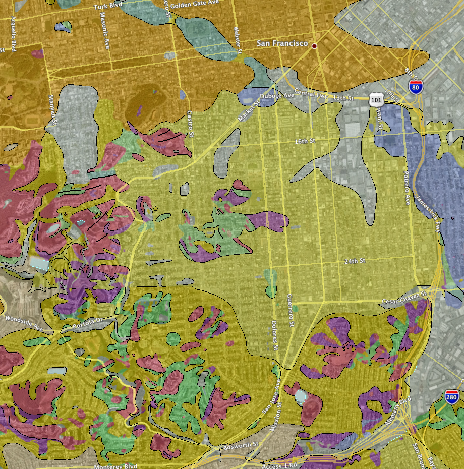
Be Alert, Know Your Chert
Know you’re going to be at a boring holiday party? Then download this handy geological map layer for Google Earth! Provide entertaining commentary all evening!
Guest: “You are so lucky! Did you know you live at a nexus of Franciscan Complex chert and Great Valley serpentinite? Such complex weathering!”
Host (whispering to spouse): “Who let him in? I said no more fucking bloggers!”

You can activate the geologic abbreviation key by clicking on “Unit Labels” in GE and referencing the color coded index.
Looking north, hovering over Excelsior.

Metropopulous
Via the always awesome fake is the new real:
The 50 biggest US metro areas in blue vs their orange states (with the metro areas chopped out), scaled by population, sorted by size.
Can you find the Bay Area? It took me a while. Sacramento, maybe if you’re from there. But you’ll never guess San Jose.

If you give up and can’t find the Bay Area: SFBay / Sactown / SJC.
Most of the metro areas are complete mysteries to me — go to FITNR and hover over the images for help.
(Apologies to Neil Freeman on the reformatting, but trying to fit into the WordPress 450px width limit. Found via The Map Scroll.)
Let’s Take A Drive Down Serpentine Ave
Eric Fischer points us to this 1859 Assessor’s map of Serpentine Avenue, the predecessor to Cesar Chavez nee Army. It shows lots for sale along Precita Creek, Bernal and San Jose Road. Edited verison below, original here.

Serpentine followed the old stone wall marking the northern border of Jose Bernal’s giant plat of land.

Here’s a zoom on the plan for the creek and the road (with west up):
 72")
Note S Van Ness is called Howard, 29th Dale and 30th is Grove.
That would have been a rather entertaining drive. And that little park on Coso Ave and Precita used to be a gravel pit! Typical aggressive land sales on the top of Bernal… Curious if any of the bridges were in place but just not shown on the 1857/1859 Coast Survey map.

Also of interest is the 1861 Langley Map. Looks like development was slow.

In the 1880s, the city built Army Street and Precita creek was redirected into a sewer (one that is supposed to be replaced next year). By the 1890s, as Eric previously mentioned, Serpentine Ave turned into a legal quagmire as it never really was a legal road. Whoops!
Now all we have left of Serpentine is that jaunty little corner of Capp into Mission and CC.

This Is As Clean As It Gets

I half expected a 7-Up ad to break out.

Mission and CC: Same As It Ever Was
Looking north on Mission at Cesar Chavez (the heart of La Lengua) at the new facade of the 3400 Cesar Chavez building, soon to be apartments and a Walgreens:

Here’s the same intersection in 1931 via SFPL:
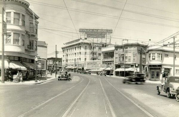
Even the Palace Steak House was there! (kidding).
I rather like the reestablishment of the rounded building corner. A bit different from 2 years back, with an abandoned paint store on the left that was once a car dealership.

Here’s the Sanborn map of the intersection in 1915. It shows a saloon on the NE corner, (though it looks more like a produce store in the 1931 shot — I’m slammed right now but feel free to dig around the 1927 and 1938 city directories and post in the comments if you find anything interesting.)

Click for PDF of a wider map.
Per TK’s request, red are saloons, yellow are liquor stores. In fact, the North Star Brewery was on Capp between Mission and 26th:

Here’s the same intersection in 1930-1950 — the building in the black and white photo was torn down and turned into a used car lot. (Green are car-related businesses — dealerships, repair shops, gas stations. Mission and Army seems to have been the Richmond Auto Mall of the day.) Click for a PDF of a wider slice of the area:

(If you are running Firefox, you may see the above animated PNG that blinks back and forth IN TIME showing the rather dramatic widening of Army Street as noted by Gillian in the comments. But you may need to click and open it in another window. And unfortunately, it doesn’t seem to work in Safari, no idea in IE. I used the APNG editor in Firefox, and I do know Safari can show animated PNGs, so if anyone has a clue, pipe up.)
UPDATE: I just discovered a detailed site history in the city’s Preliminary Mitigated Declaration for 3400 CC:
Historically, the building has been used for both new and used automobile sales and service until about 1990, when it was briefly used as a furniture rental business. From 1991 until early 2006, it was used as a Kelly-Moore paint store. Previous uses included “Jesse C. Lanning Autos” (1930s), “Phil Frates Plymouth” (1950s), “Jim Wessman Lincoln Mercury” and “Auto City Wholesale” (1960s), “K&C Chrysler/Dodge (1969 – 1982) and “Rent-a-Center” (1990). There is no documentation indicating that 3400 Cesar Chavez is associated with any historic event, especially since the building was built in a more modern style and in a more outlying neighborhood than other historic Beaux-Arts style auto showrooms located along Van Ness Avenue.
And 80 years later we get apartments again.
Hey, does anyone know if the Walgreens will move from 30th and Mission? Or will there just be two in four blocks?
La Rondalla, Reboundar?
Jeff Hunt of Muni Diaries send us this intriguing shot of actual renovation at La Rondalla, taken last night:
Earlier in the day, our new “Plywood Diaries” reporter had observed that construction workers had removed an entire window, noting that “in broken English, they said that the same restaurant is coming back.”
Our Valencia St agent remarks: “I only hope they also renovate the food quality”.
Oh, and 901 Valencia used to be a saloon.

(1899 Sanborn map — 20th on the top, Valencia on the left, Lexington on the right.)
And because you know I am going to look up what it was… From the 1898 city directory:

“Hark, Gertrude! Let us acquire beverages!”
“But dearest Wilbur, I really do feel like consuming raw mollusks.”
“Well, let us do both at Mr Lauterwasser’s Liquor and Oyster Emporium on 20th and Valencia!”
Sometime after 1904, In 1909, the bar was taken over by Frank Lemoine.


And then John and Katherine Hill:

Prohibition turned it into a soda fountain run by H.I. Buckman, as we see in the 1927 city directory.

By 1938, it was home to the “Uneeda Coffee” Shop.

(It is good to see that horrid coffee puns know no historical limits.)
18th St Gulch, The Willows, Valencia St Hotel
KevMo at MissionMission recently referenced the classic shot of the Valencia St. Hotel between 18th and 19th after the 1906 earthquake. But that shot doesn’t do justice to how big the sinkholes on Valencia were or how much of the hotel sank. The hotel before the quake:

“When the quake struck, patrons in an all night coffee shop on the bottom floor of the four-story hotel ran from the building just in time to watch the building simultaneously lurch forward and sink, making the hotel’s fourth floor the hotel’s only floor above ground.” (Bancroft Library)

A sinkhole opened up later, right where all those people were standing. Reader Dave Dennison points out that the sinkhole was due to a broken water main, and at least 40 people drowned.

(All these years I thought these shots with the Valencia St Hotel on the left were looking south, but I was wrong — they are to the north. It certainly makes the above shot with the approaching fire make more sense.)
Here’s the 1899 Sanborn map of Valencia between 18th and 19th. You can see the two big water mains, 22″ and 16″, running down Valencia.

Another view of the sinkhole – you can see the water mains.

The steeple in the first two shots aren’t visible in the picture below, or in the sinkhole shot. There was a 5.0 aftershock at 2:25pm on the 18th. Did it come down in the aftershock or during the rescue attempts?

Soon after these pictures were taken, fire swept through the area. Those still trapped who didn’t drown, well…

(via SFPL)
More on the Valencia St Hotel here.
The “18th St Gulch” (for the lack of a better term — feel free to come up with a catchier name) was bigger than I realized. This sketch of the Mission from the 1850 looks NE from around 21st and Liberty and gives some indication of its depth.

Zooming in on the bottom right, we see the gulch at what will be Dolores and 18th, with a stagecoach hurtling out of control (ok, probably not, as it’s not even the steepest part).

I traced the topology contour lines from the 1859 US Coast Survey Map and made quick and dirty overlays to show just how much was filled in before the 1906 quake. Each color gradient is a 20 foot change.

The gulley dropped over 40 feet in half a block! At roughly 12 feet per storey, that pretty much explains where the Valencia St Hotel went. (The green area is the Willows beer garden from the 1850s/60s, and the Valencia St Hotel would later be built on the bottom left corner.) Zooming in a bit:

Note also the gulley along the west side of mission between 21st and 18th, as well as between Lapidge and Linda.
Here’s the overlay of the Valencia St Hotel on the gulch map. (Valencia on the right, Guerrero on the left). Click to zoom.

This litho of the Mission in 1860 looks west from around what is now Mariposa and Utah (via Calisphere):

Zooming in on the left we see the steep ascent above Mission Creek, with the Willows in front of the trees. The road in front of the Willows is what will be Mission Street. (via Calisphere).
")
Here’s the 1859 US Coast Survey Map. The building on the bottom left of the map (and the top center of the lithograph) may be the Jewish Cemetery. If so, Dolores Park would be to the right on the lithograph.

The background of this picture of the Willows in the 1864 taken from the Union Race Course (via SFPL) gives some indication of the slope.

I leave it as an exercise to the reader to determine where not to buy a house (or invest in a sound foundation).


