Mission and CC: Same As It Ever Was
Looking north on Mission at Cesar Chavez (the heart of La Lengua) at the new facade of the 3400 Cesar Chavez building, soon to be apartments and a Walgreens:

Here’s the same intersection in 1931 via SFPL:
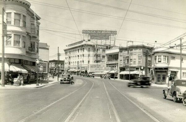
Even the Palace Steak House was there! (kidding).
I rather like the reestablishment of the rounded building corner. A bit different from 2 years back, with an abandoned paint store on the left that was once a car dealership.

Here’s the Sanborn map of the intersection in 1915. It shows a saloon on the NE corner, (though it looks more like a produce store in the 1931 shot — I’m slammed right now but feel free to dig around the 1927 and 1938 city directories and post in the comments if you find anything interesting.)

Click for PDF of a wider map.
Per TK’s request, red are saloons, yellow are liquor stores. In fact, the North Star Brewery was on Capp between Mission and 26th:

Here’s the same intersection in 1930-1950 — the building in the black and white photo was torn down and turned into a used car lot. (Green are car-related businesses — dealerships, repair shops, gas stations. Mission and Army seems to have been the Richmond Auto Mall of the day.) Click for a PDF of a wider slice of the area:

(If you are running Firefox, you may see the above animated PNG that blinks back and forth IN TIME showing the rather dramatic widening of Army Street as noted by Gillian in the comments. But you may need to click and open it in another window. And unfortunately, it doesn’t seem to work in Safari, no idea in IE. I used the APNG editor in Firefox, and I do know Safari can show animated PNGs, so if anyone has a clue, pipe up.)
UPDATE: I just discovered a detailed site history in the city’s Preliminary Mitigated Declaration for 3400 CC:
Historically, the building has been used for both new and used automobile sales and service until about 1990, when it was briefly used as a furniture rental business. From 1991 until early 2006, it was used as a Kelly-Moore paint store. Previous uses included “Jesse C. Lanning Autos” (1930s), “Phil Frates Plymouth” (1950s), “Jim Wessman Lincoln Mercury” and “Auto City Wholesale” (1960s), “K&C Chrysler/Dodge (1969 – 1982) and “Rent-a-Center” (1990). There is no documentation indicating that 3400 Cesar Chavez is associated with any historic event, especially since the building was built in a more modern style and in a more outlying neighborhood than other historic Beaux-Arts style auto showrooms located along Van Ness Avenue.
And 80 years later we get apartments again.
Hey, does anyone know if the Walgreens will move from 30th and Mission? Or will there just be two in four blocks?


That’d make three in eight blocks (there’s another
Walgreens at 23rd and Mission).
The 1931 photo is also interesting for its non-17-reasons Redlick-Newman sign.
Cool post. Thanks for the color-coding! LOVE Serpentine Ave! Does it live on down by 25th and Hampshire?
Re: Walgreens. I can walk from my office building downtown to three stores by only crossing one street. Where else are you going to get a doggy Snuggie and a paternity test in the same location, though?
PS I still think the paint store is going to be there when I cruise by; it’s going to take a long time to change my mental image of that intersection. Hopefully by that time, I’ll get used to not calling it Army. (Which upsets me because I respect Cesar Chavez so much…)
Whoops, forgot to link to the signs.
Much the same, but Army/Chavez from Harrison to Guerrero was widened from 40′ to 100′ between 1947 and 1950 – tearing down ~44 buildings and evicting everyone living in them. That’s why the crosswalk across Chavez at Capp/Serpentine is so perilous.
The housing on top of the liquor store on the 1915 map wasn’t torn down until sometime in 1948 or 1949. A Mrs. George Erzegovich is quoted on Page 15 of the 12/4/47 edition of the Chronicle as objecting to being evicted so that her building (3380 Army Street – the current Palace Steak house parking lot) could be torn down in order to widen Army Street between Harrison and Guerrero. I believe this holds true for the housing above the saloon/produce store on the northwest corner as well; after the widening, the part of what remained of that lot became the parking lot for the car dealership and then the paint store.
Walgreens is *obsessed* with San Francisco. We have Walgreens like Seattle has Starbucks.
I’m working on overlaying the maps into Google Earth. It’s tricky (I didn’t do a very good job on the 1950 map, will be reposting soon) but it’s pretty easy to see the widening.
Maybe Walgreen’s and Safeway can get together to redevelop the whole Mission Safeway/Walgreen’s sites into mixed-use housing over grocery store next to a plazaless 30th & Mission BART Station. No more “ass” of the Safeway on San Jose Avenue.
Serpentine is related to Gulchie, the monster that lives under 18th and Valencia.
Actually, this is true — it was a crazy-ass angled road that ran along the edge of the Precita Creek marsh.
In fact, it followed an old stone wall that was the northern border of the Bernal Rancho.
Agreed, anonymouse. Funny how $500 million doesn’t seem like that much money any more.
There’s some study on the Safeway redesign floating around but I can’t find it right now.
(Though of course I’d also want 30th St Station to connect to a new crosstown BART line that extended north to Noe/Castro/Fillmore and south to SSF/SFO. Or one that led to a second crossbay tube.)
Serpentinewas adjacent to the path of part of the Islais Creek. I learned this from the family that owns the old Hollywoood Video site. They used to own that whole city block – it was a DeSoto dealership following the widening and evictions; and they heard stories from relatives about the Islais Creek being culverted.
The 30th Street BART study is http://www.bart.gov/docs/planning/30th.a.pdf
I think Precita Creek is the common name referring to the Serpentine Avenue creek. Islais Creek is the one under Alemany Boulevard.
For some reason there was a big legal mess over whether Serpentine Avenue was ever legally a street (and therefore could not be closed or sold off without giving alternate access to property fronting on it). Some of the details are in the 1896 San Francisco Municipal Reports.
Eric Fischer is amazing!
I think Precita Creek is part of the Islais Creek Watershed – the bottom of which is essentially under Cesar Chavez Street. There’s a really big sewer line under San Jose Avenue that moves the water from the Glen Park part of the watershed into the sewer under Cesar Chavez Street…which is overwhelmed during big storms and then floods the inner Inner Mission. The San Jose Avenue sewer line is likely going to be relocated (serpentined?) in order to accommodate the rebuild of St. Luke’s Hospital.
http://museumca.org/creeks/1630-RescIslais.html#
Thanks!
Oh, I didn’t realize that was how the Glen Park drainage worked. I had always assumed that it flowed under Bosworth to Alemany and didn’t realize that there was a connection along San Jose Avenue. I shouldn’t have jumped to that conclusion!
Same here, Eric. Unfortunately I wasn’t able to attend Christopher RIchard’s lecture last week. I found some future-tense references to the College Hill tunnel in the 1914-15 Sups report:
“It is of particular public interest to note that not only will the Islais Creek outlet sewer be installed between Mount Vernon avenue and Oneida street as soon as necessary rights of way will have been secured but that the City Engineer has prepared a comprehensive plan for the construction of… the College Hill tunnel which will divert the sewage from Islais Creek at Mission street into the main sewage system of the City… “
Here’s some more infrastructoporn.
And for no particular reason other than it involves water and drama, check out this construction report for the new 44″ water main under Bernal last year. There is some serious soap opera intrigue:
“After many unsuccessful attempts, GSB concluded that the TBM did not have enough overcut to correct the misalignment. By August 13, Golden State decided to remove all the tunnel support and pull the second machine out of the tunnel. On August 17, with the machine out of the hole, GSB walked off the job. They had joined the project as a subcontractor to Affholder, had given it their best try, and were done.
On August 20, Affholder remobilized its last tunneling crew. The Bernal Heights tunnel project was to be Affholder’s last project. All of its other projects had been completed, and all of its tunneling crew had been released. Therefore, Affholder had to mobilize a new tunneling crew from North Carolina.”
Ah ha, here’s the study I was thinking of: “SFCTA – Mission South of Cesar Chavez Transportation Study“.
Make that 4 Walgreens stores – you’ve forgotten about the one hidden away in St. Luke’s (Valencia between Cesar Chavez and Duncan).
I’ll give you 3.5 for that one.
But the Mission-Valencia corridor is certainly turning into El Camino del Pared Verde.
Anybody who’s interested in Serpentine Avenue and Precita Creek will probably like this map of it from the San Francisco County Recorder’s records:
http://bsm.sfdpw.org/subdmap/subd/books/A/A_108.TIF
the hulking mass of the new building completely overwhelming that corner is gross and the rounded edge is nothing like the ’31 building. oh how i yearn for the quaint, respectfully distanced-from-the-curb modesty of that sweetly awninged beauty.