Islands of SF Poster
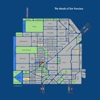
Behold! What if each San Francisco neighborhood were an island, and the streets canals?
Click image to zoom. Posters now on sale!
And check out the rather awesome wrapped canvas version! (Pics here.)
Regardless, a handy reference. Backstory here.
Other exciting posters include my Hyperlinear BART map (black-background also available, along with matching t-shirts).
31 Comments
leave one →
Trackbacks
- Noe Valley Plaza — Try It, You Just Might Like It « Burrito Justice
- Rhonda Friberg » Blog Archive » San Francisco Maps
- Ghost in the Shell « Burrito Justice
- Cole Valley Alley Solves Cistern Mystery « Burrito Justice
- The Islands of San Francisco « Burrito Justice
- Big Day in New and Old Media « Burrito Justice
- This Map Speaks a Thousand Words…If Not, More – Mission Loc@l : News From San Francisco's Mission District
- Reassembling Sutro « Burrito Justice
- San Francisco Archipelago « Burrito Justice
- Top 5 Reasons Readyforce Happily Moved to San Francisco | Readyforce Blog


Hi. We used this map and the Valencia canal pics to illustrate this short story, as part of our Shareable Futures series: http://shareable.net/blog/centaur-in-brass-2041
You’ll see that we gave full credit to Burrito Justice, and so hopefully you don’t mind. Thanks so much for this amazing project!
Cool! NIcely done, glad you could use it.
How soon are the posters coming? I’d be interested in getting one for the office… :)
Soon. Gotta fire up the map-making machine and add the bell-shaped St Mary’s, and see if anything else comes to mind.
What will be the best way to find out about posters when they go on sale? Is there a “show me the posters!” mailing list, or should I just stay tuned to the site :)
Stay tuned! (or follow on Twitter). Will try to remember to email you too.
You got it! Following :)
LOVE the Islands of SF Map. First saw it in the recent Ed Lee for Mayor mailer but wondered why Golden Gate Park was not green (huh?). Glad it seems to be corrected here. My order is on its way…
Cool! Can you take a picture? I haven’t seen it yet. They paid me to use it, but they changed the colors, so I was like whatevs.
Also, use of art != endorsement, etc. I would have voted for @mat.
There’s also another SF entity that will be using it as a big 10’x10′ public display, will let you know the details when it’s ready.
One thing is always that one of the most widespread incentives for applying your cards is a cash-back and also rebate present. Generally, you’ll get 1-5% back upon various acquisitions. Depending on the cards, you may get 1% returning on most expenses, and 5% again on buying made at convenience stores, filling stations, grocery stores along with ‘member merchants’.
Between T-Hill and the Financial District is Jackson Square. It’s on the National Register of Historic Places and deserves to be added to this map.
http://en.wikipedia.org/wiki/Jackson_Square,_San_Francisco
It’s not Oceanside…it’s Oceanview
thanks — stupid typo I made keeps on popping up on preview images. accurate on poster!
Also, it is not Miraloma…it’s Miraloma Park.
Great stuff. Well done. Thanks for the creativity. When will it be available in poster and or t-shirt form?
Suggestions:
1. Please don’t forget our “real” islands – Alcatraz and T.I.!
2. Any way you can add SFO, which is officially SF real estate?
3. Would love to see an island/yellow spot for SF Gen’l inside the kink that I believe is Hospital Curve in your canal between Potrero and Mission.
4. Inner Mission and Outer Mission?
Thanks! Tried printing a shirt but just couldn’t get the resolution on the text. Posters have been available from the start, see Zazzle link.
http://www.zazzle.com/islands_of_san_francisco_large-228741577507875065
Real islands are outside the scope of this squarish map. Good point on SFO but that’s not going to make it in.
Outer Mission is there. Not subdividing the Mission further, alas.
Trivia: SF has quite a few real islands. I believe the Farallons and part of Red Rock island (near Richmond Bridge) belong to the city and county of SF, and so does the tip of Alameda island. Also, if you’re including the exclave of SFO, you have to count the Sharp Park golf course in Pacifica, and maybe the jail in San Bruno.
Your map is outstanding! St Mary’s Cathedral on Geary/Gough – aka cathedral hill – has been compared to a Maytag washing machine – love your idea of bellshaped. Bravo!
Ahh… you missed Lakeshore: http://en.wikipedia.org/wiki/Neighborhoods_in_San_Francisco#Lakeshore
I am regular visitor, how are you everybody? This post
posted at this site is actually fastidious.
I want to purchase the Islands of SF poster and customize it Do you have any examples of texts or images. We live in LA now, but would like to capture that we lived in the Marina …”we lived here” or “our hood” text? Need a better suggestion. Thanks.