I’m. Too sexy for this rope walk.
I have about 50 half written articles in my WordPress drafts folder. The good news about this procrastination is when someone beats me to an historic writeup, I have instant commentary! Such was the case today on Twitter when chatter erupted over the old Tubbs rope walk.
https://twitter.com/wroush/status/434779620135559168
Historic rope walk? You had me at “Sanborn map pasted over”…
A few years ago, Wade Roush over at Xconomy dug deeply into those oddly angled buildings on Third Street between 22nd and 23rd.
The ghosts of former industry in Dogpatch, Hunters Point and Butchertown could very well be its own blog. The short of it is as downtown SF developed in the 1850s and 1860s, the messy industries and ones that needed lots of space moved to SESF.
These particular buildings were once adjacent to the Tubbs Cordage Company’s “rope walk” factory that was built in 1856 and lasted until 1963. Today, one of them is the Hells Angels’ clubhouse, and Wad Roush disovered that in the 1980s, two of them were owned by none other than DAVID RUMSEY.
WHAT.
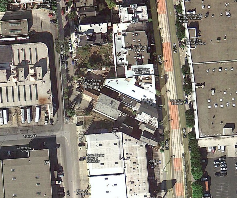
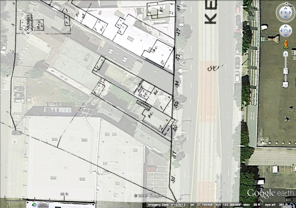
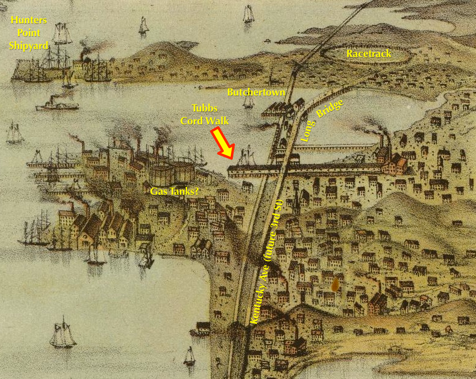
Anyway, here are their 1915 facilities presented in BurritoVision. Click to zoom.
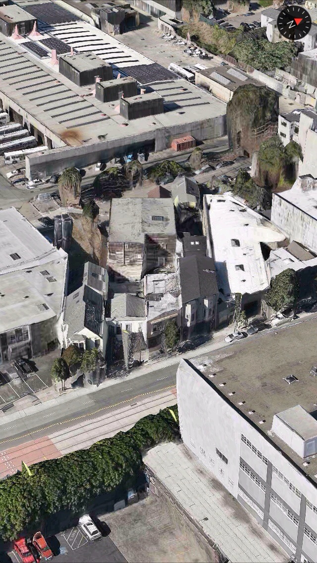
Close up of those angled buildings (1558,1560, 1562, 1564, 1566 and 1568 Kentucky), which match up pretty well:
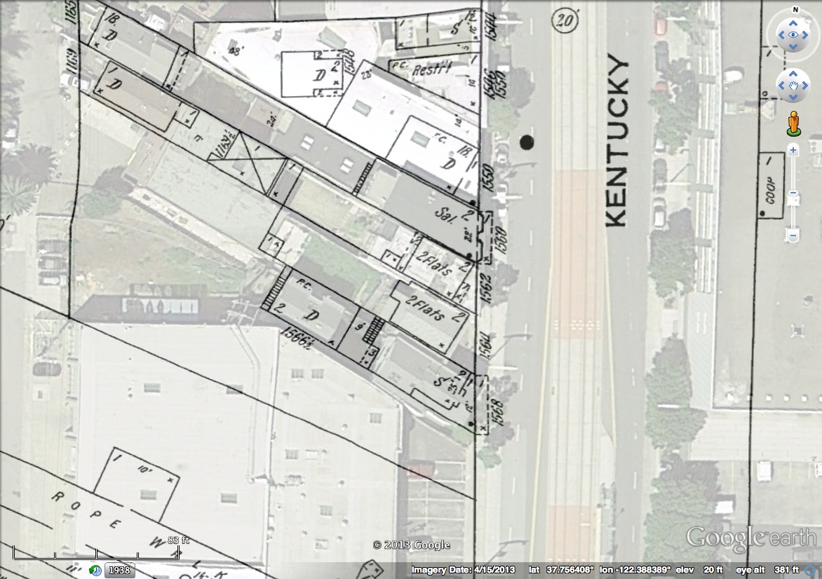
Overlaying the 1886 maps, the lots look the same, but the buildings, 46 aka 1564 and 45 aka 1562 Kentucky look different, and that saloon (which I can’t yet track down) isn’t there:
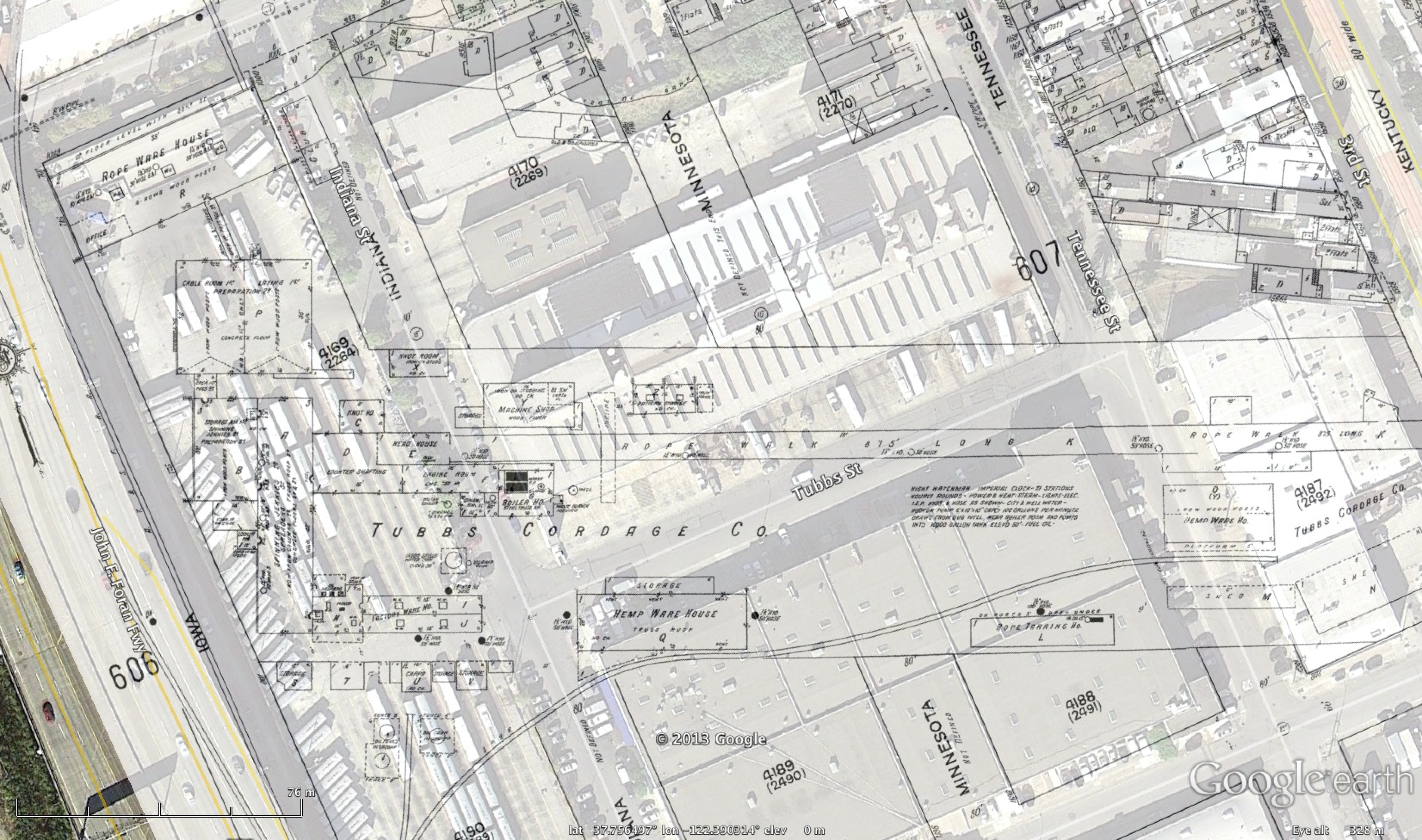
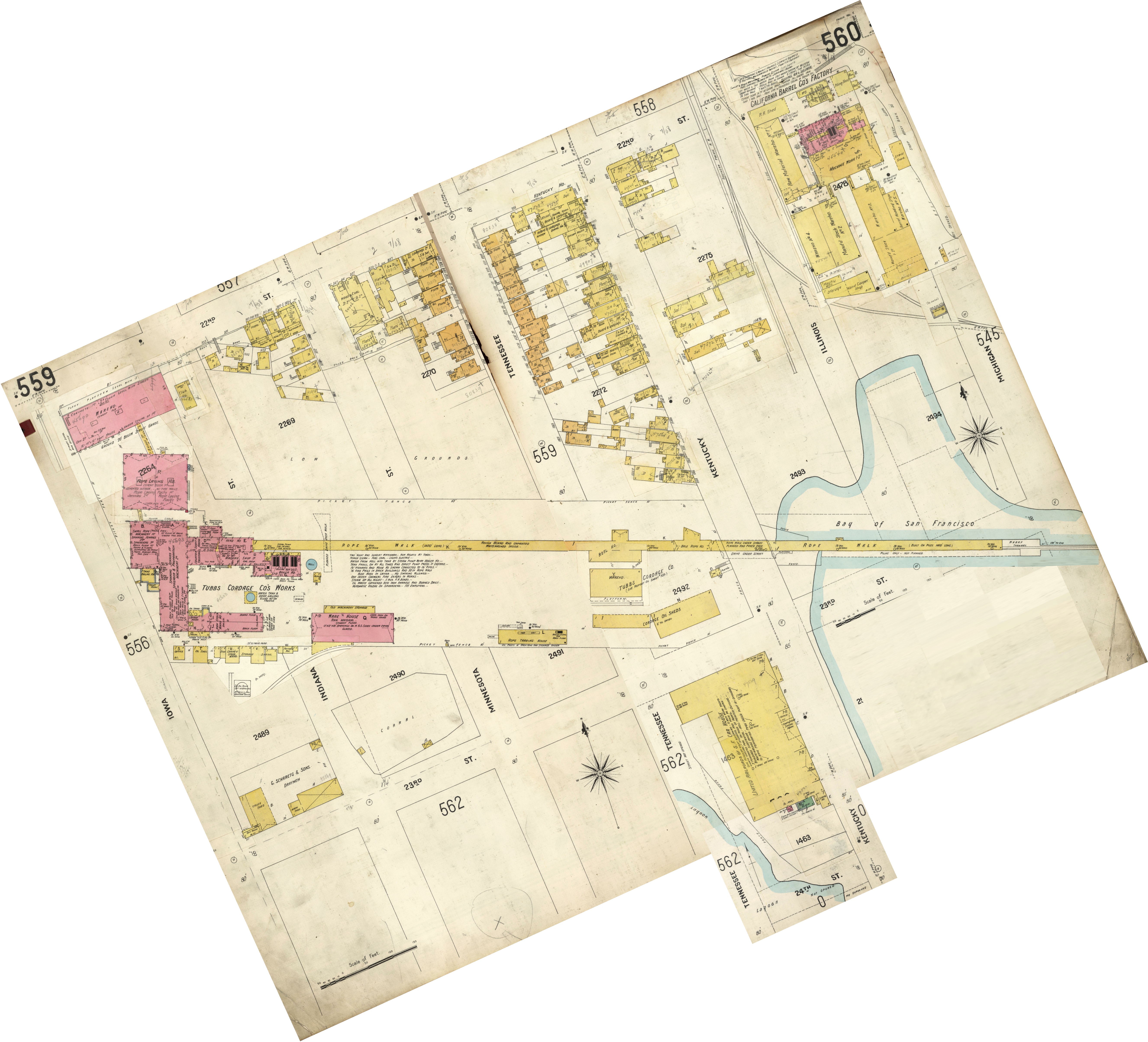
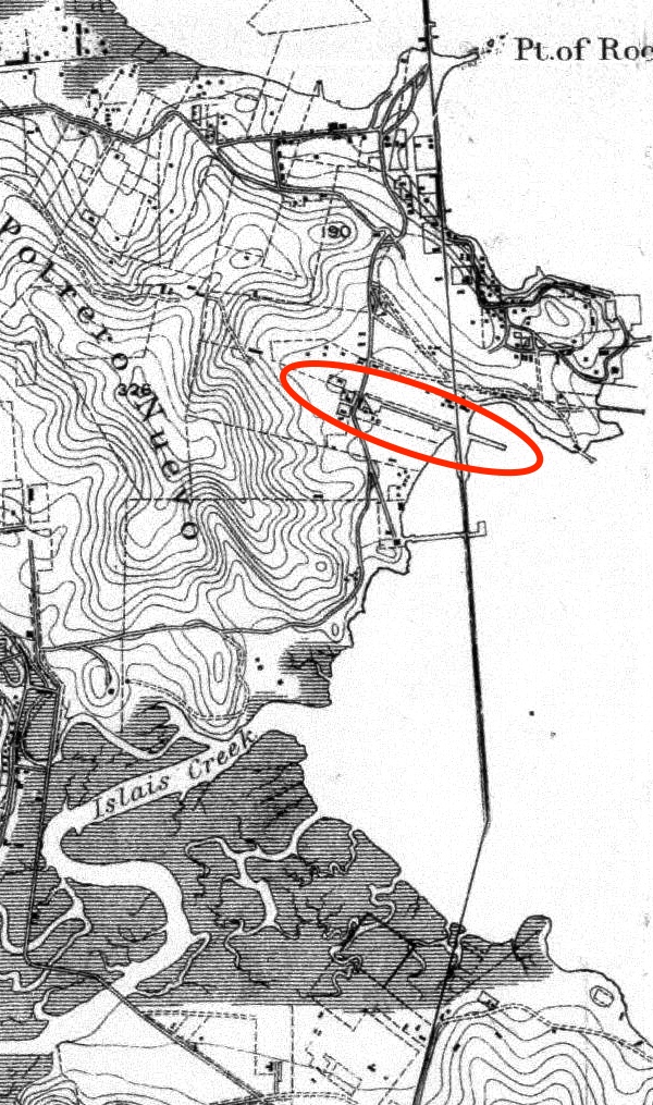
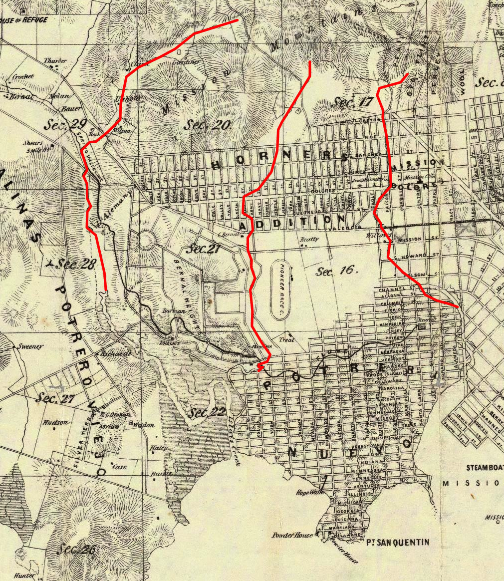
And here are the 1905 Sanborns, stitched and rotated to show the full length of the plant. IANARM, but apparently you needed an extremely long “rope walk” to make rope — at 1400′, it dodged under Kentucky/3rd Avenue and jutted into the Bay on piers (click to zoom):
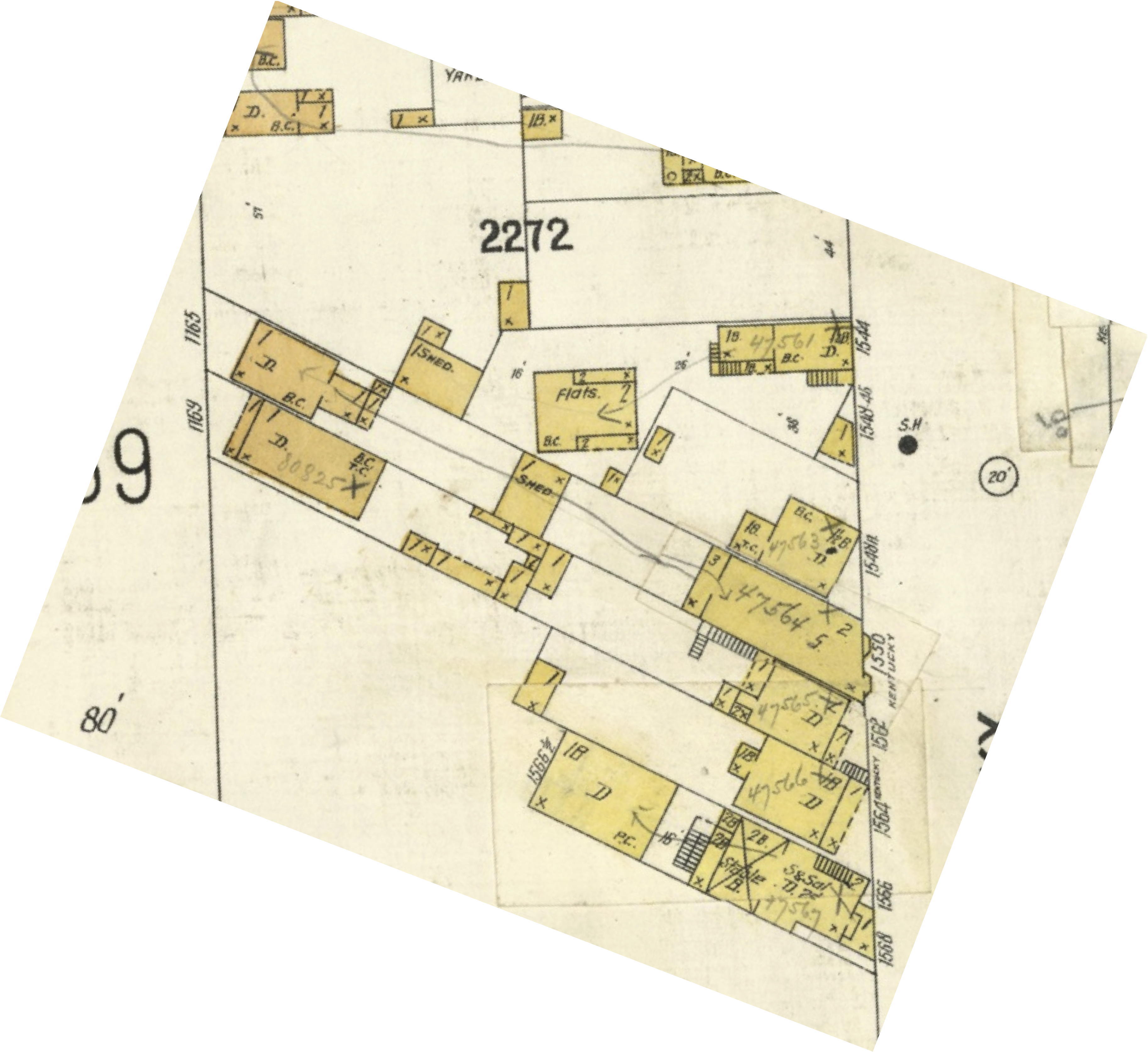
Zooming in on our angled buildings:
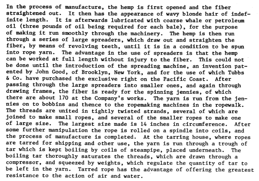
The National Parks Services gives us a glimpse into how Tubbs & Co got started:

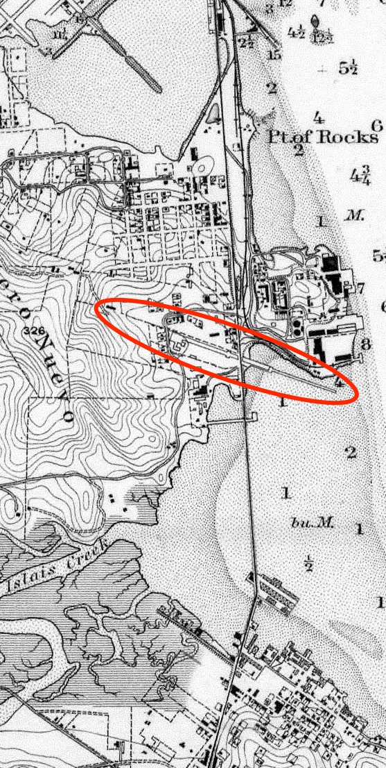
The 1886 Sanborns don’t show the extend of the rope walk, but it can be seen in this crop from the 1884 Coast Survey map, where it sticks a rather significant distance into the bay.
And this 1878 birds-eye drawing of San Francisco, looking from the north…
…along with this 1868 bird’s eye, looking from the west.

And the 1869 Coast Survey map:
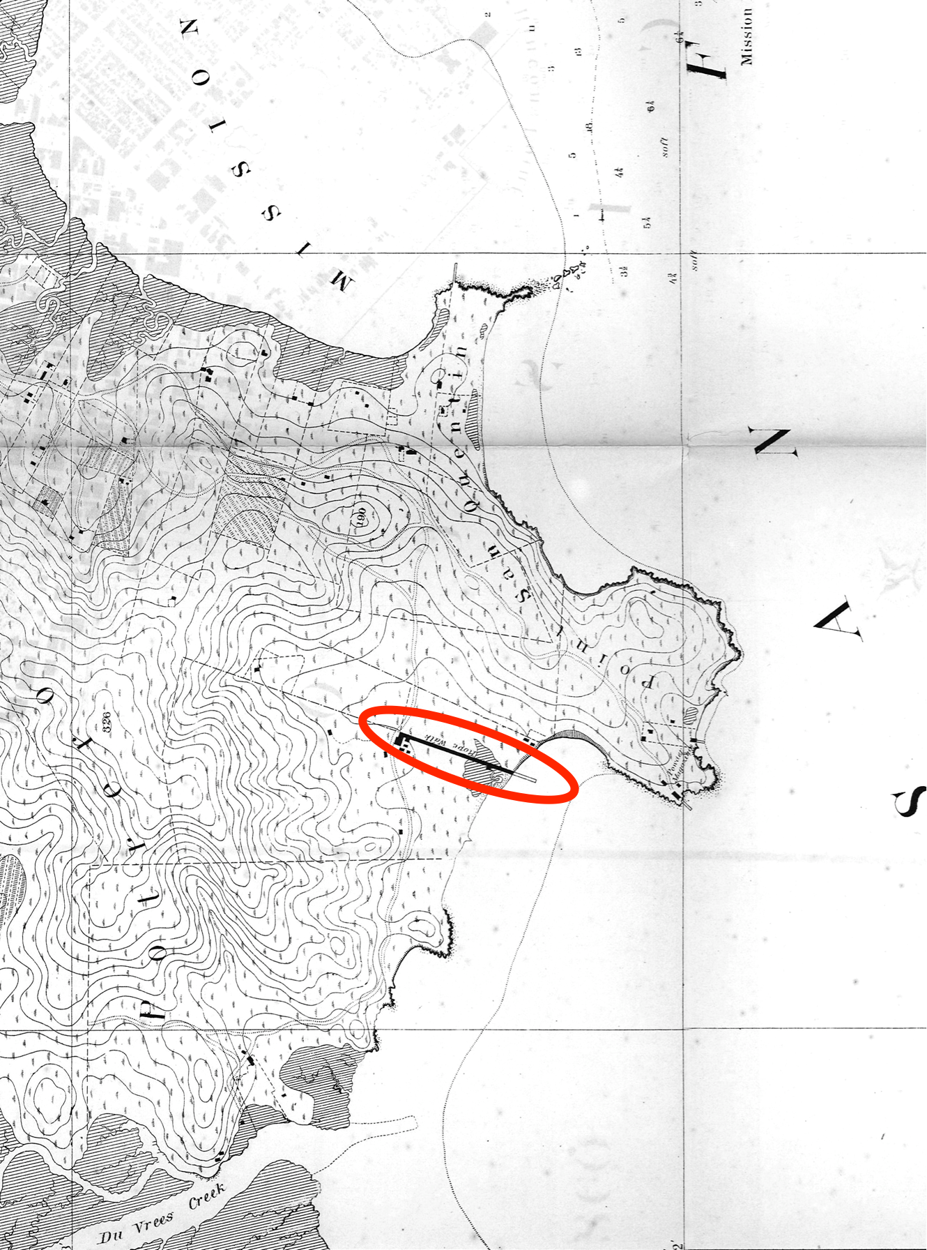
And the 1859 Coast Survey map:
And just to give you an idea of how utterly isolated the area was while downtown SF boomed, here’s the rope walk sometime after 1857 (looking north, with the Bay on the right).

Zooming in on the 1859 Coast Survey map (which was actually surveyed in 1857, the same time as the photo), you can see some of the same buildings, as well as the fences (marked in green on the map). The red is my estimate of the field of view — I’m guessing the photographer was standing around 25th and Connecticut, looking to the northeast.
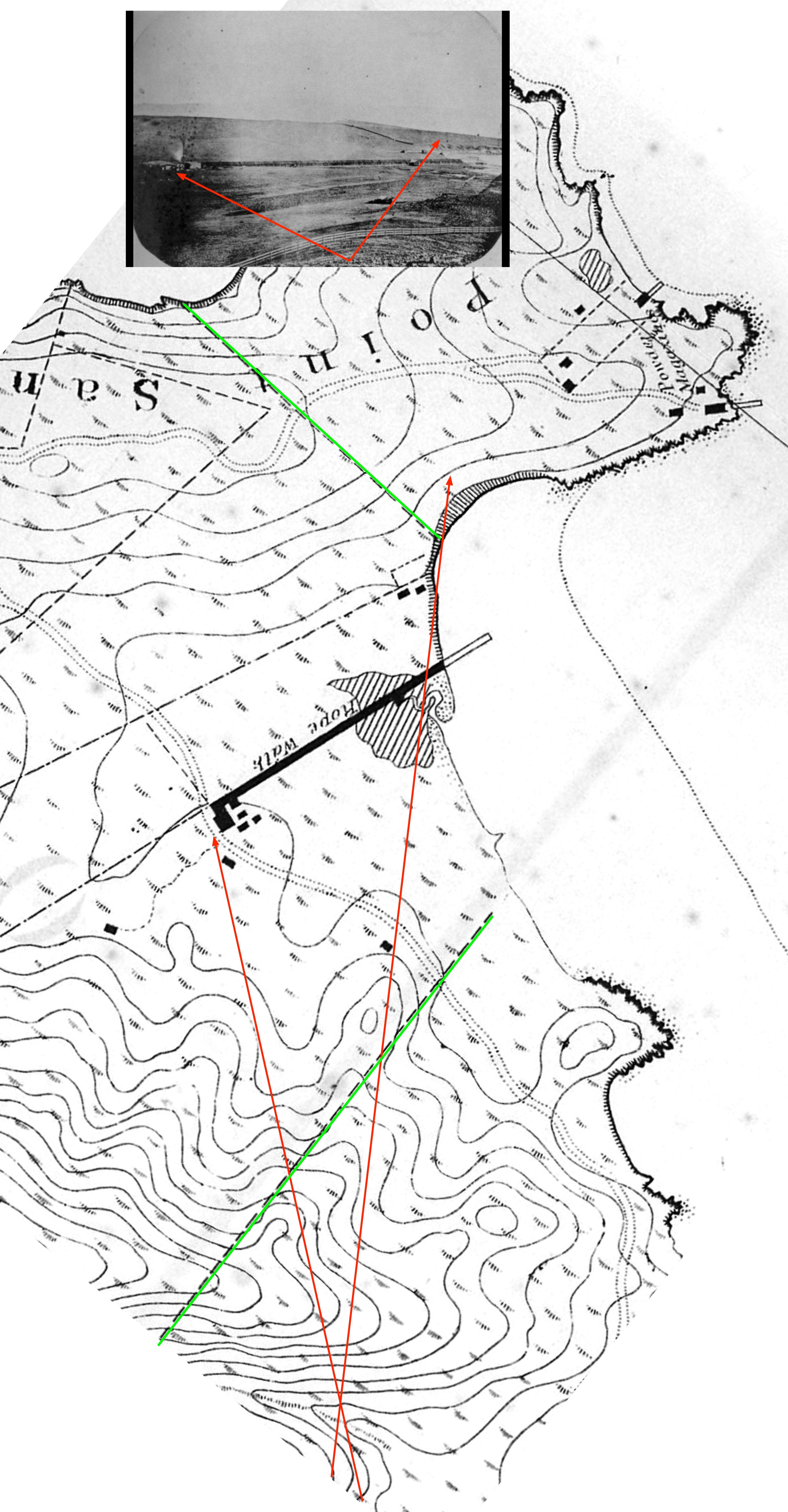
The rise is the lost Irish Hill (you can see the Oakland Hills in the very far distance). The powder magazine would be just to the right of this photo — in fact, that small building you see on the crest of the hill may be part of that complex.
An ad in the California Daily Alta from January 1857 (around the time that the photo above was taken) proclaims “the establishment of a very superior rope walk” — a bit defensive perhaps, but they must have been seriously pissing off the folks shipping rope from the East Coast in clipper ships around the horn.

July 1857: “No really, our rope is as good as what you can get out east.”

1858: But in case you want other people’s rope, we have Ratline! Spunyarn! Marline! Housline! Seizing!

1858 & 1859: “Not only do we excel in rope and cordage, but our choice of typeface cannot be beat.”
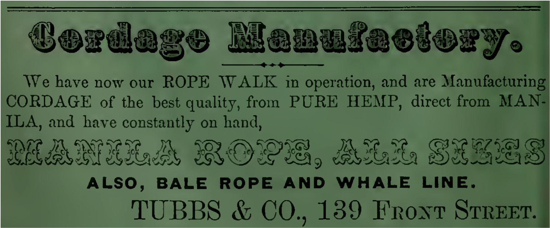

1860: prices reduced! Constantly manufacturing! Whatever you want! The rope walk NEVER SLEEPS!

In case you were wondering how they made rope, the National Parks Service has your back with this short history:
1878: You want rope? We’ll make you rope. (But we’d prefer to make hay rope.)

1888: as they got bigger, the name of the company gets changed.

The Tubbs brothers passed away in 1896 and 1897, but the company kept going. The rope walk lasted for over 100 years until 1963.
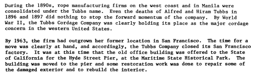
The old Tubbs office building on Front St was moved to the Hyde Street Pier where you can see it today.
.JPG)
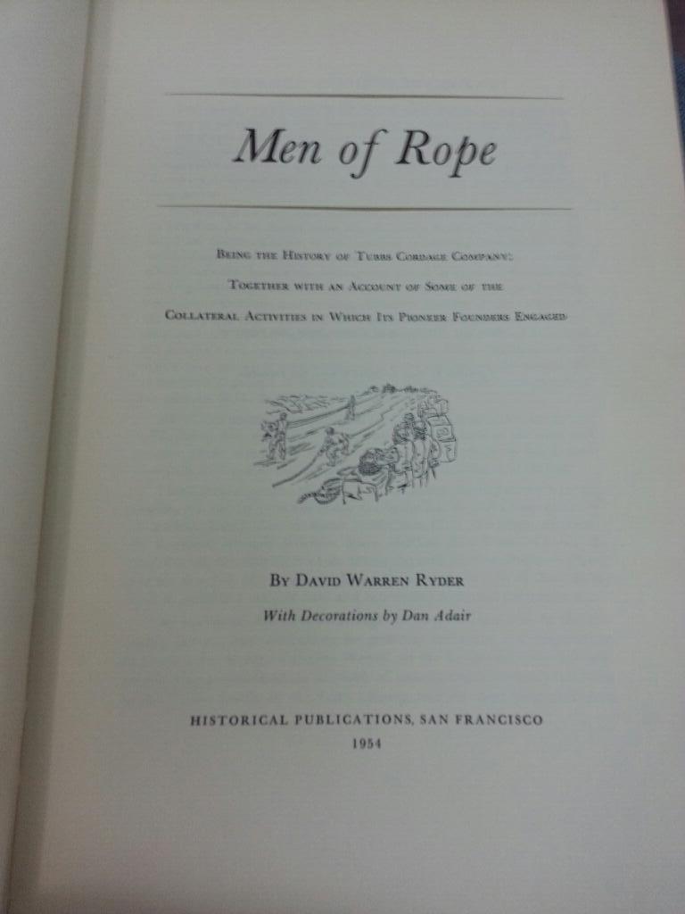
And I just learned from Wade Roush that there’s a book published in 1954 called “Men of Rope” which is now on my reading list.
https://twitter.com/wroush/status/434919657913335809
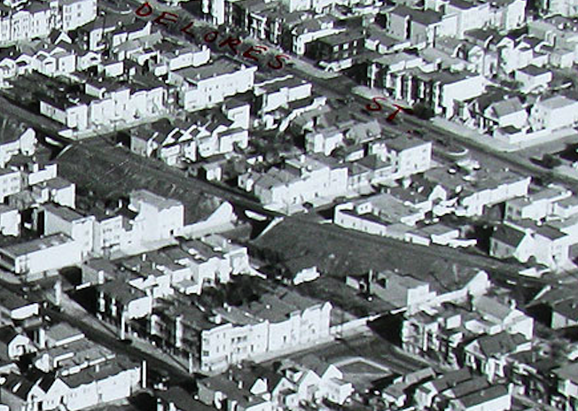
Dolores Street Bridge
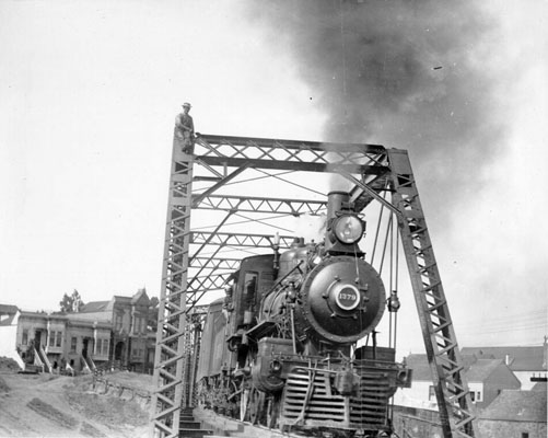
All hail Eric Fischer, master of historophotography! The Southern Pacific trestle bridge over Dolores Street in 1910.

More on the path of the SPRR here and here. And @markasaurus did a nice walking tour a few years back.
The resolution on this is crazy good. Hello serious guy holding your watch seriously:
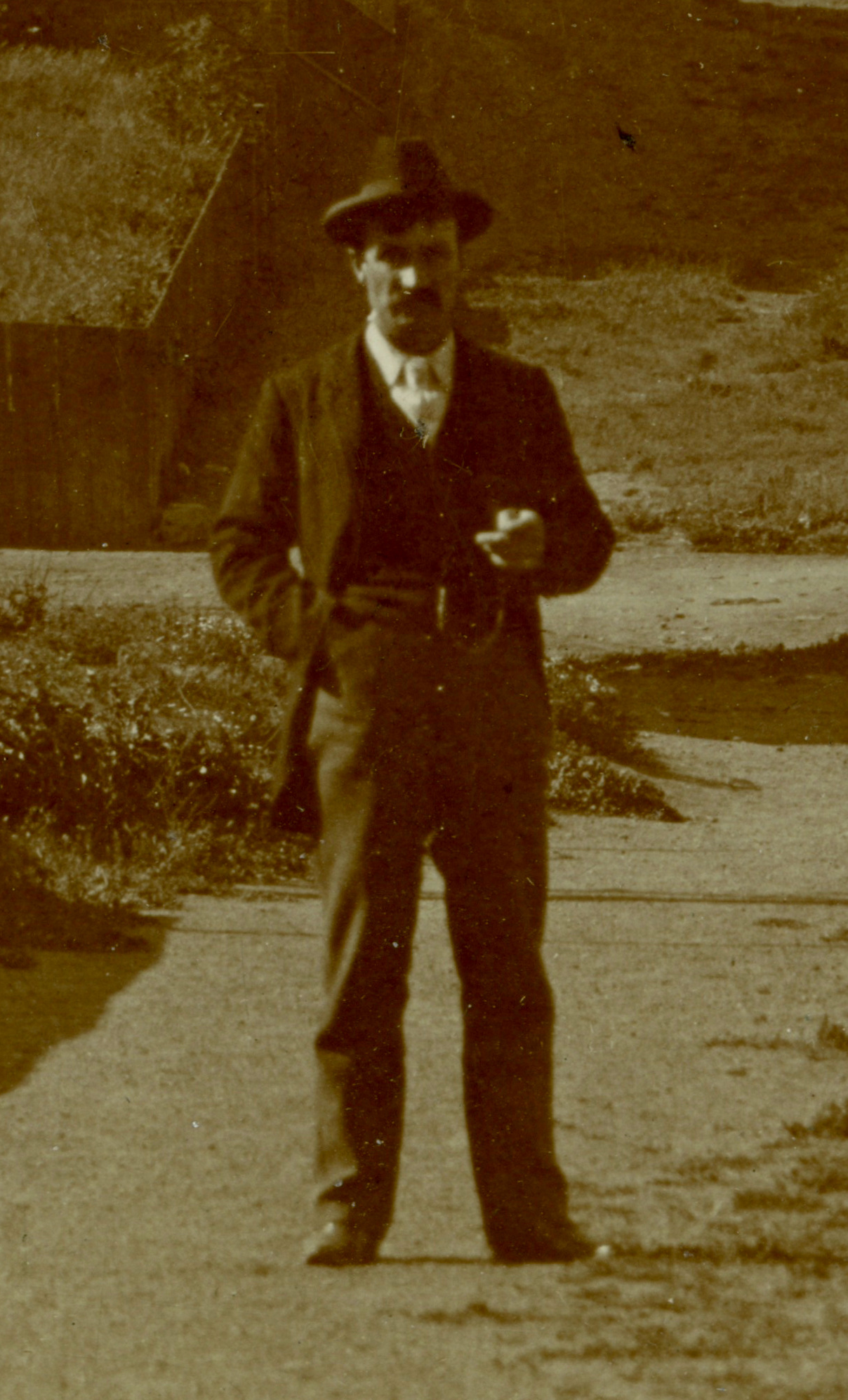
Ha!

Hey, look, it’s the milk truck!
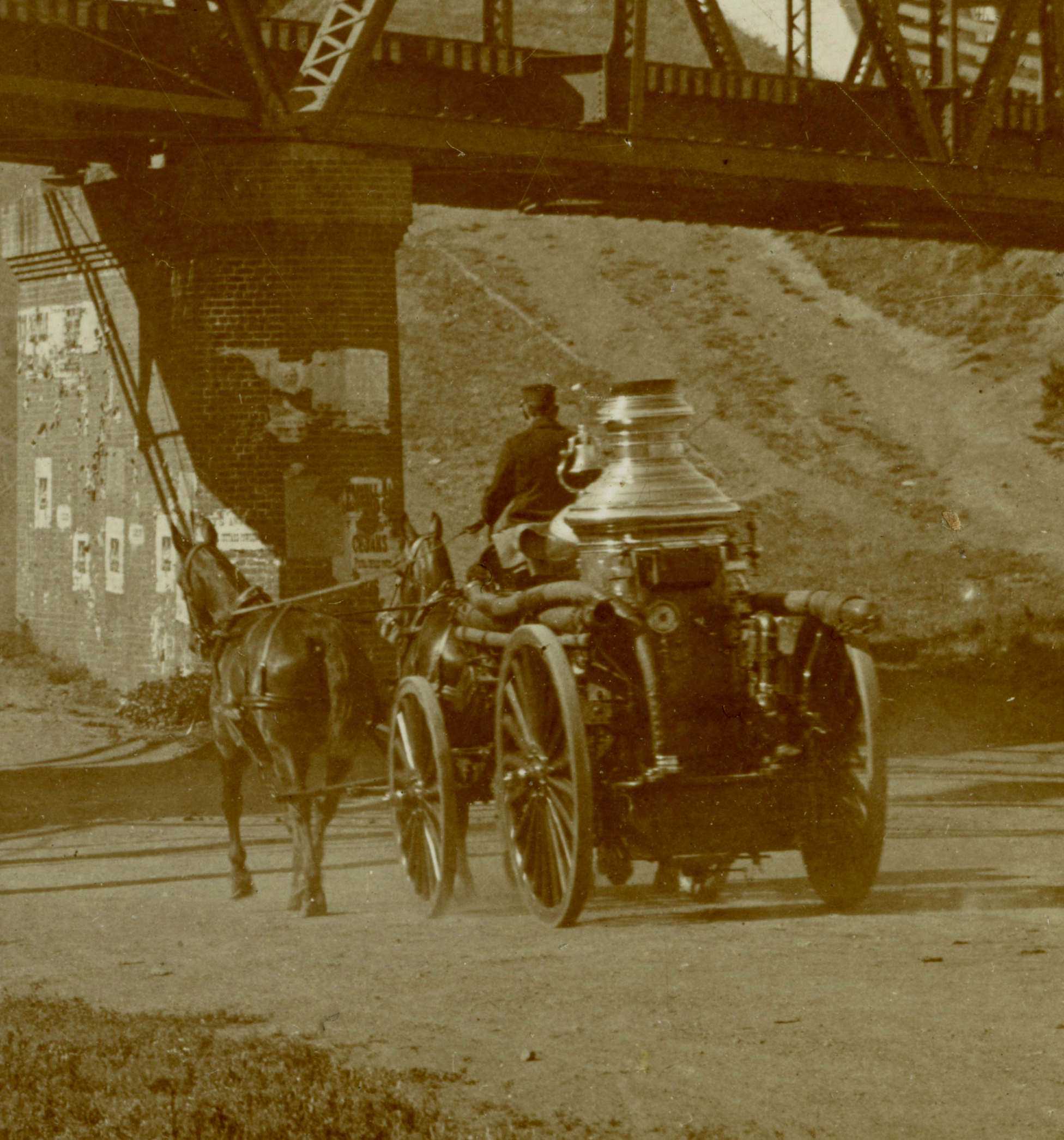
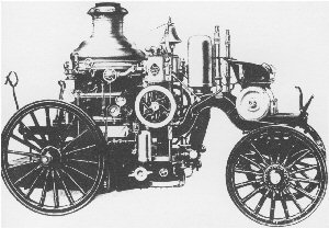
Just kidding. It’s the Anchor Steam truck. OK, OK. It’s a steam fire engine. IANAFM, but from the shape of the boiler and location of the bell, I’m guessing it’s a Nott:
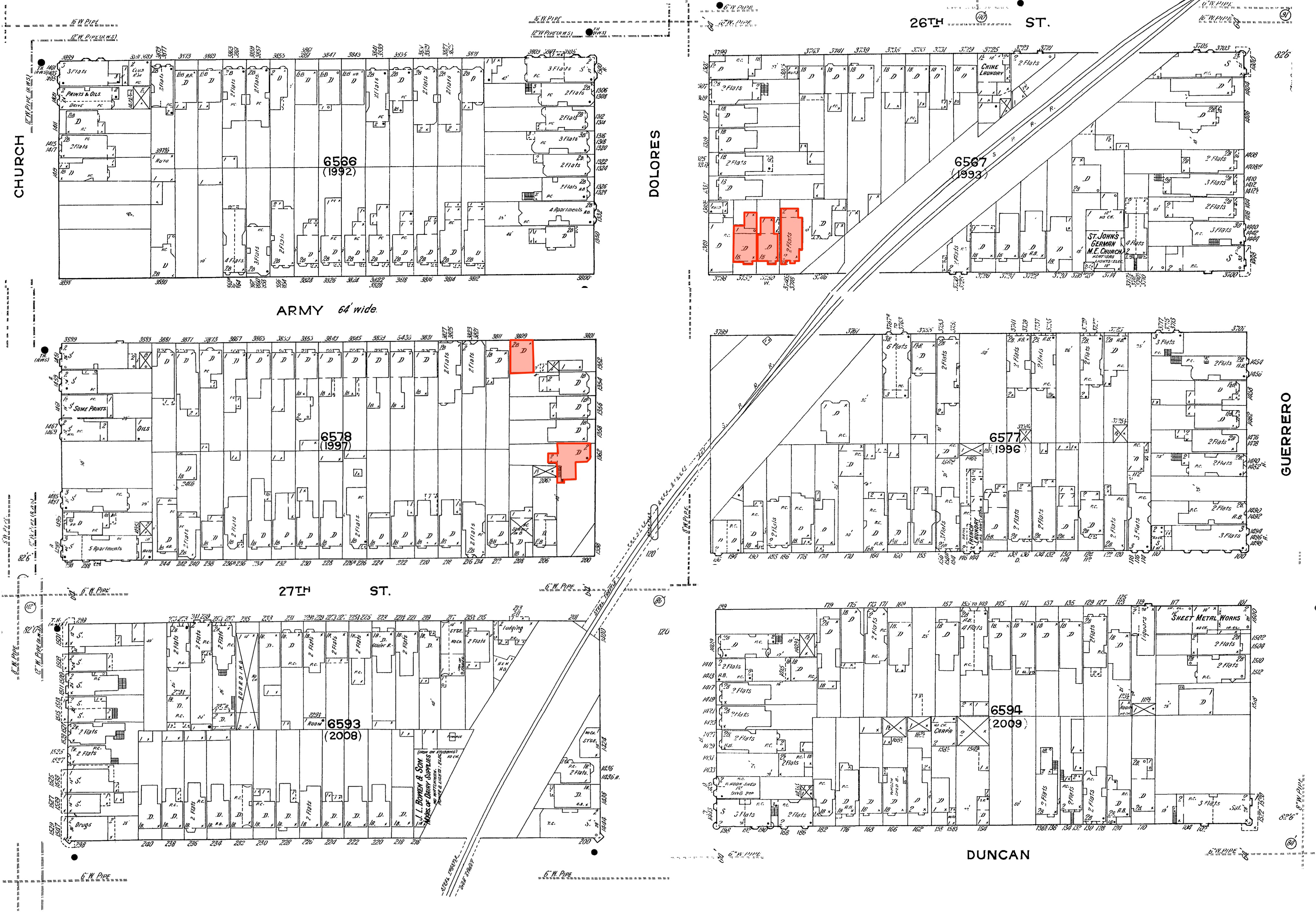
The three houses on the right up on CC/Army are still there:
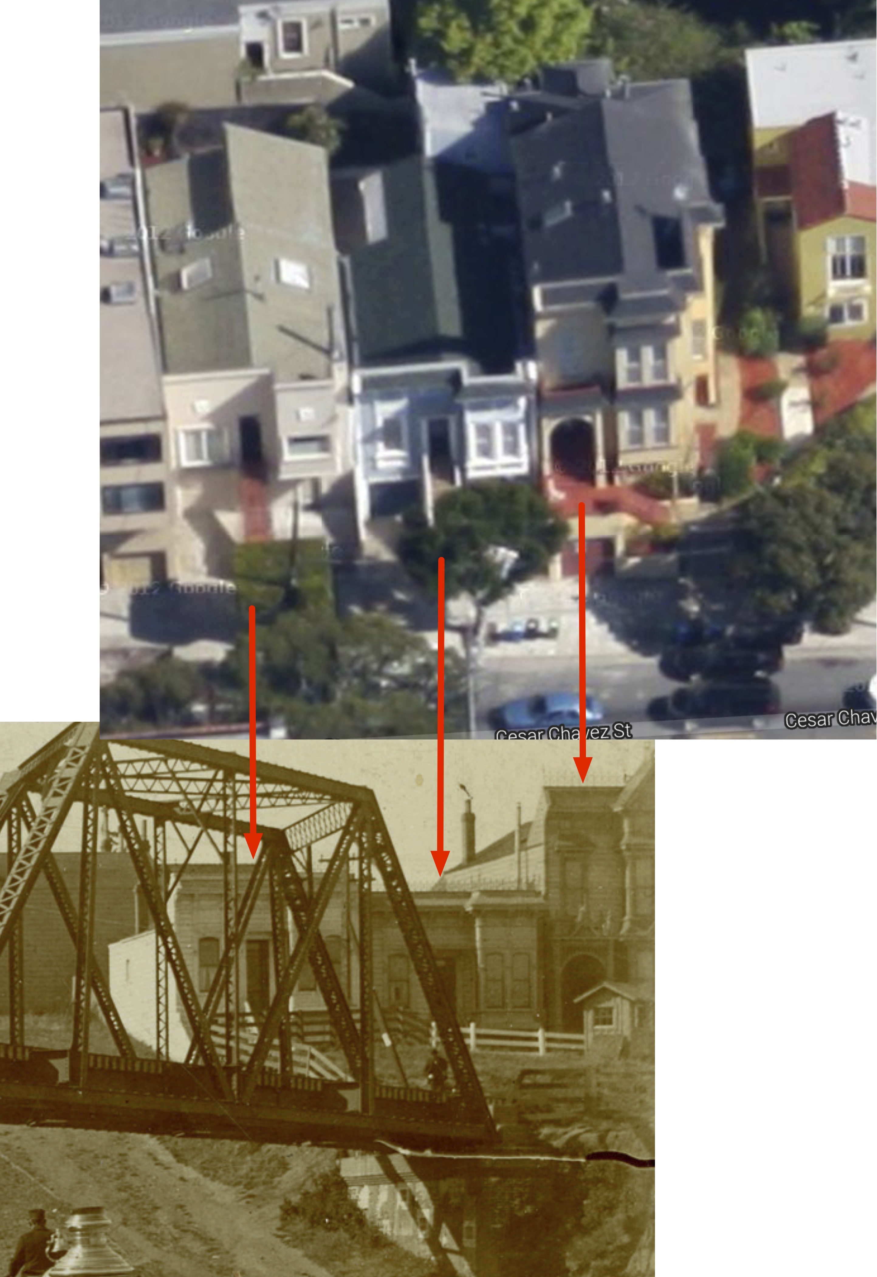
You can see the same houses in the 1910 photo that’s available via the SFPL photo archive — they are on the left, so this photos is looking northeast:
(via SFPL)
And the matching up the houses visible near the west side of the bridge:

You can see that really tall house with the peaked roof on this 1920s photo via (FoundSF):

I stitched together some 1914 Sanborn maps for your historo-reference.
I hadn’t realized that the all-knowing FoundSF had written a piece on the Dolores Street Trestle (hey, great band name) until after I started this post. They found this rather amazing photo taken around 1940, just a few years before the funeral train service was stopped and service on the line completely shut down.
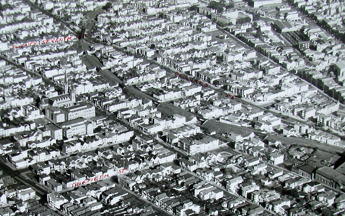
I knew there were bridges over each street, as we’ve seen them from the 1907 photo from atop Bernal…
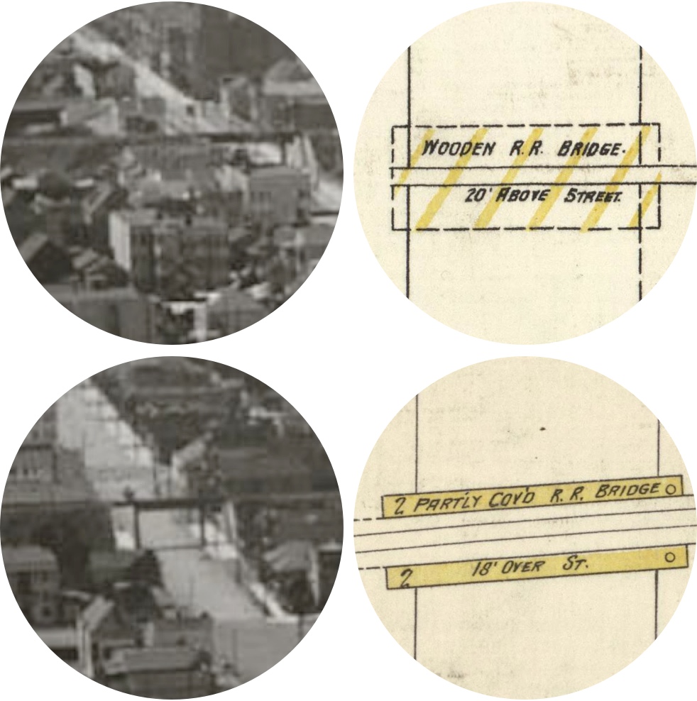
…but I had never appreciated just how *damn big* that berm was. Zoom and enhance on the 18-20 foot pile of dirt running through the middle of Noe Valley:
I cannot even imagine how many kids must have gotten in trouble for climbing up that thing.
Harder to imagine is that the train was there first, and the street grid grew around it. The railroad was built in 1860-1863, and the berm was to minimize the change in grade from the Bernal Cut.
The route curved as it did to squeeze between the two racetracks in the Mission:
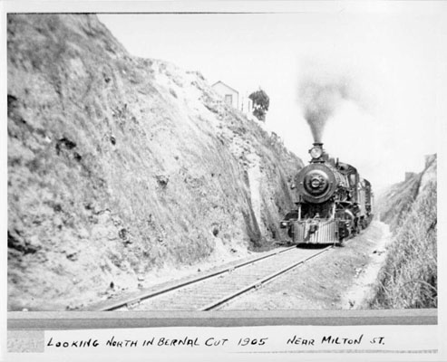
The Bernal Cut was never an easy path for trains to take — on the way up from Daly City they apparently needed a helper train — and the current Bayshore alignment (that Caltrain takes today) was built from 1904 to 1907. The trains through Noe and the Mission gradually faded away:
The Bayshore Cut-off was completed December 8, 1907. The new line shortened the distance between San Bruno and San Francisco by four miles and eliminated Bernal Cut as a mainline. The original line through Bernal Cut remained as a branch line with one passenger train a day which operated until 1930. The last through-freight train operated over the old line in 1942, after which the middle section was abandoned…
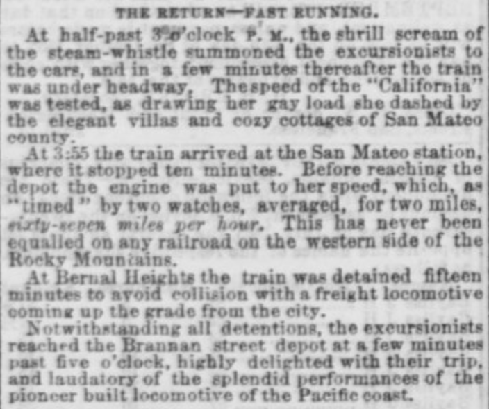
I’ve previously mentioned that the train from San Francisco to San Jose set a speed record in 1865:
The first full-sized steam locomotive produced in the state of California, an American 4-4-0, was built for the SF&SJRR by the Union Iron Works in San Francisco. It was appropriately named the “California”. Its inaugural run was August 30, 1865, during which it set a speed record of 67 mph (107 km/h).
Here’s the article in the Daily Alta the day after the “fast running” of the California. (I love the use of italics.)
149 years later, Caltrain’s top speed today is just 79 mph.
Hey, at least it’s not slower! Well, actually, it is.
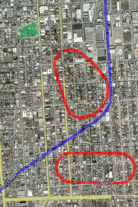
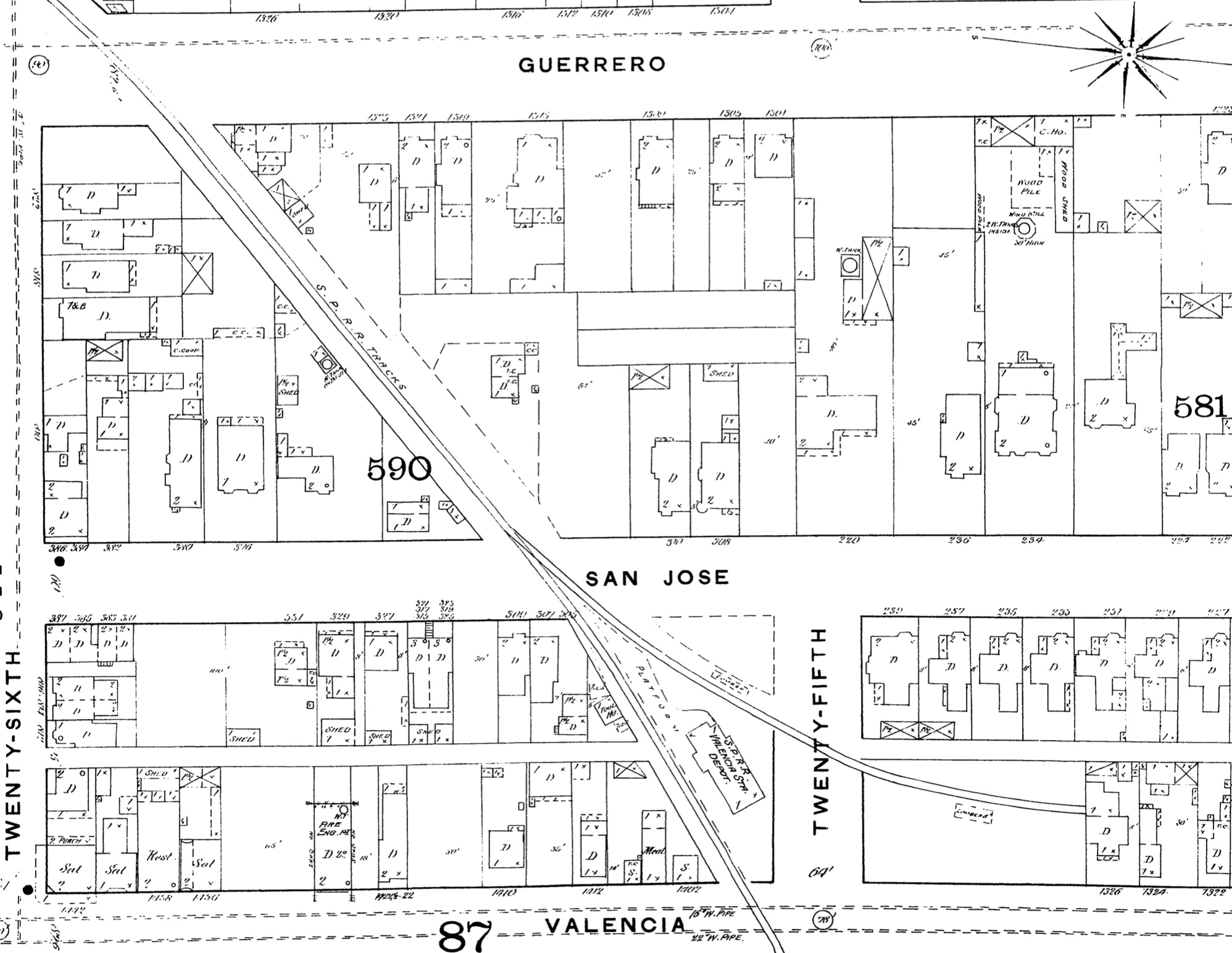
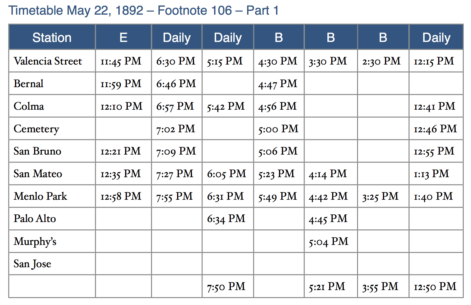
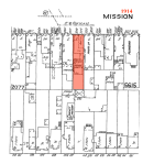
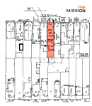
Looking at old timetables from the late 19th and early 20th century, it was possible to get from the train station at Valencia and 25th to Palo Alto in less time that it takes today on Caltrain and BART. Here’s the station from the 1889 Sanborn map (San Francisco 1886-1893 vol.+3, 1889, Sheet 88_a):
The 1907 (pre-Bayview cutoff) schedule available over at wx4.org:
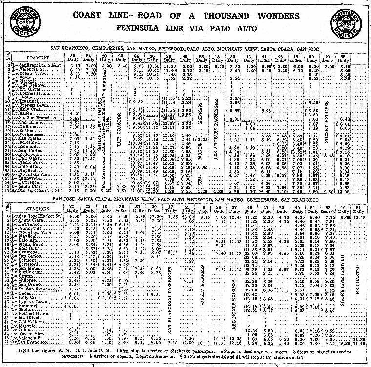
Zoom and enhance:
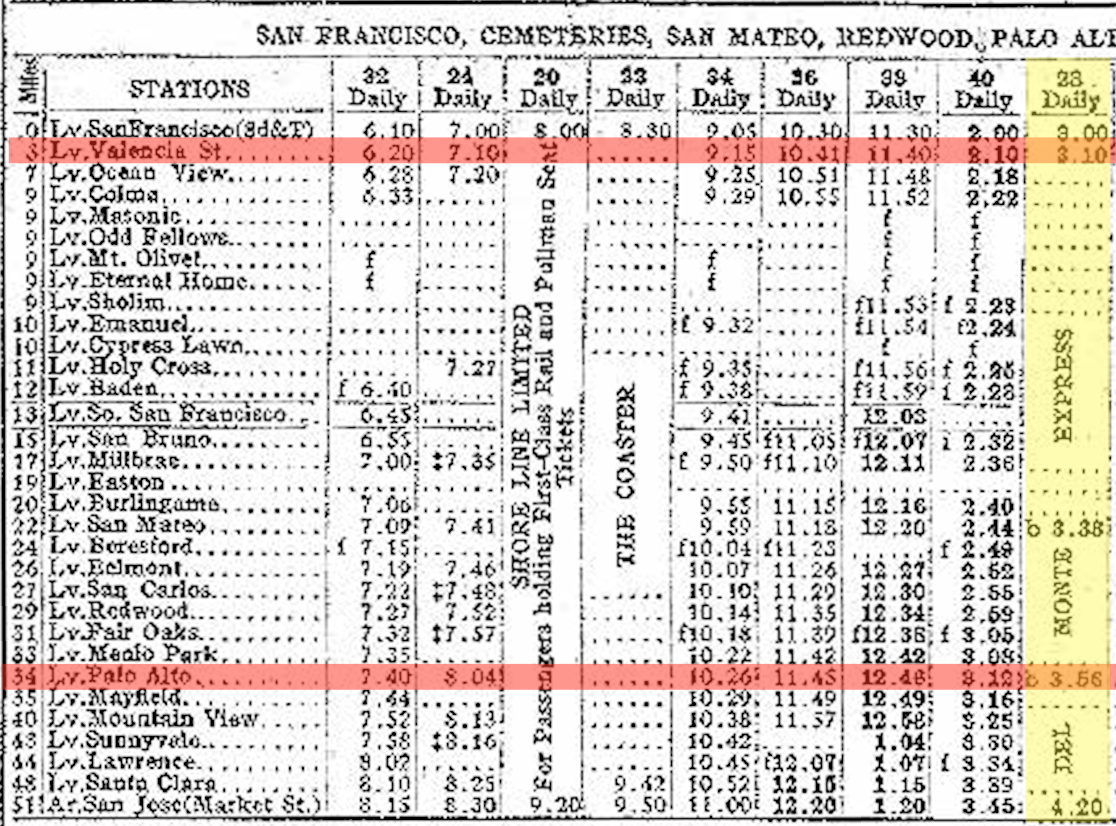
Yes, you could make it in 46 minutes from Valencia St to Palo Alto in 1907. You’d be hard-pressed to *drive* to Palo Alto in 46 minutes from 24th & Mission today, even without traffic.
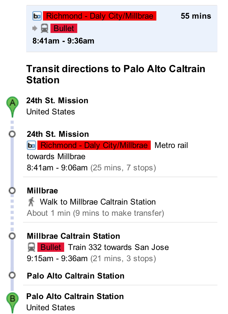
As far as I can tell, the fastest possible BART/Caltrain connection you can make today is 55 minutes. (It’s more typically an hour or 1:05 in my experience, but feel free to comment if you are one with that commute.)
And in case you think my choice of the Del Monte Express is unfair, a typical connection back in the day was a bit over an hour or so…
This rather incredible report on the history of the SF to SJ line written in the 1940s has 1892 schedule and fare information. 55 minutes to Menlo Park. 1:11 to Palo Alto.
Whoa, that 95 cent one-way fare to Menlo Park adjusted for inflation is $23!

But the monthly pass of $9 comes out to $226, not all that far from today’s 3 zone fare of $179.
While I realize that you can catch a baby bullet from 22nd St to Palo Alto in 34 minutes, you still have to get to the charming 22nd station — good luck with the bus connection.
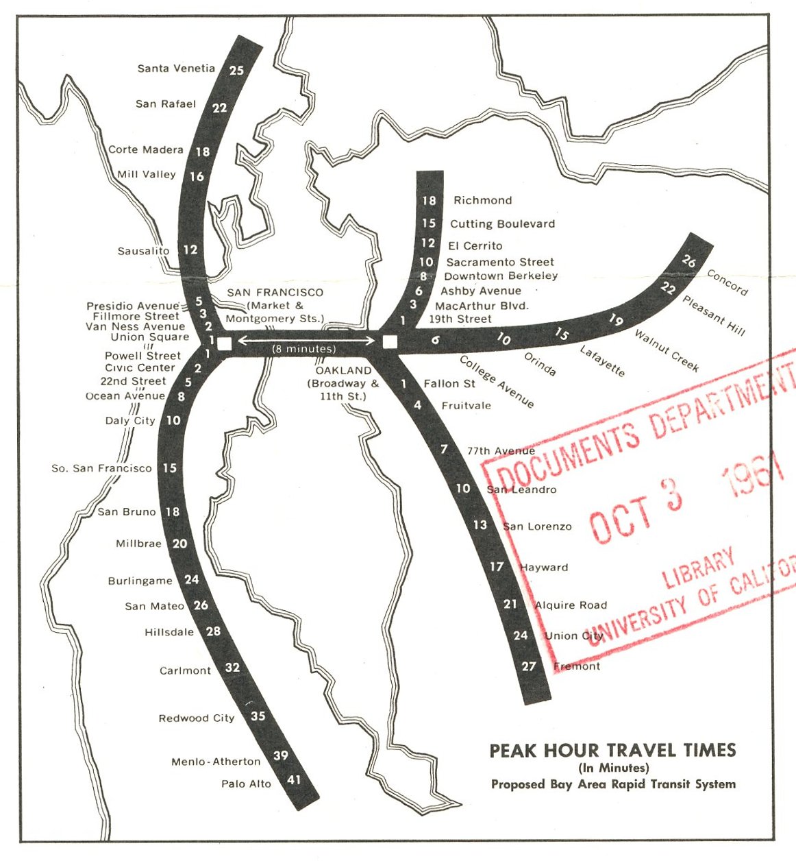
For those who want to be sad, the original plans for BART had it running to Palo Alto (and even Los Gatos!!)

This map from Eric Fischer shows estimated travel times — the times are a little on the optimistic side, but 36 minutes to Palo Alto from an unbuilt 22nd Street station.
Of course, it’s easy to look at the benefits of a centrally located above-ground transit system and ignore the inevitable tradeoffs.

And then there’s the steam and the soot:
SCHWARTZ: We think of steam as being this very romantic form of transportation, we hear that sound. But the reality was, there were huge disadvantages. The reality of a steam train is, if your windows are open when it shows up, your whole room will be filled with soot, and the stink of the soot, and the cleaning of the soot, and the noise. Not everybody wanted these.
ECHEVERRIA: Round about the early years of the twentieth century, the public was fed up.
But soot, steam and 100 decibels might not even keep housing prices in Noe Valley under $2 million.
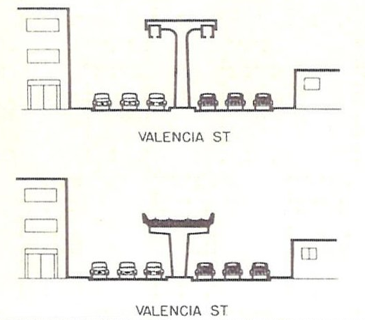
One 1956 proto-BART plan had an elevated system that ran above Mission and Valencia:

Sadly, the Bay Area doesn’t have a coherent transit policy or we’d have a train that goes over 100 mph and we’d have regular service to Palo Alto in 15 minutes and San Jose in 30 minutes. But hey, let’s save that kind of efficiency for China, Europe and Japan.
Rock Me Jerrameyus
@yayitsrob noticed this:
https://twitter.com/yayitsrob/status/424665702633852929
Which meant I had no choice but to create this:
PizzaHacker Reboot
Hooray! PizzaHacker is officially opening up for business tonight in the heart of the TheLowerBernalFlatsHigherMissionNotNoeCoprosperitySphere La Lengua!

Photo via Bernalwood
Tonight you get free slices if you mention La Lengua! (Kidding. Free slices for everyone, I think. But do mention your support of La Lengua.)
PizzaHacker is at 3299 Mission, the site of the old Inkas restaurant.
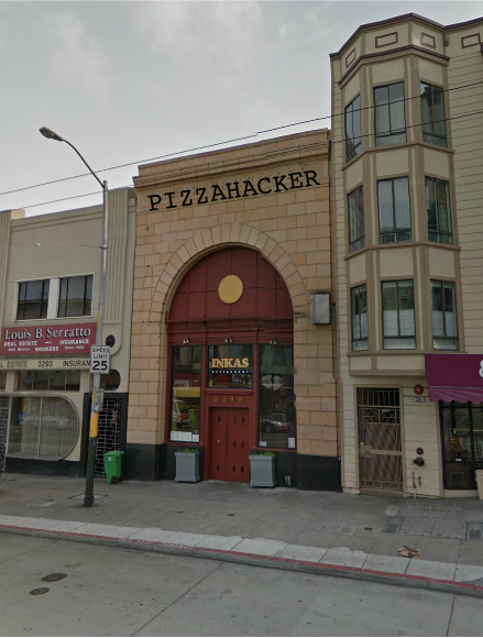
This used to be the Wide Hive record store, which used to be the American Trust bank…
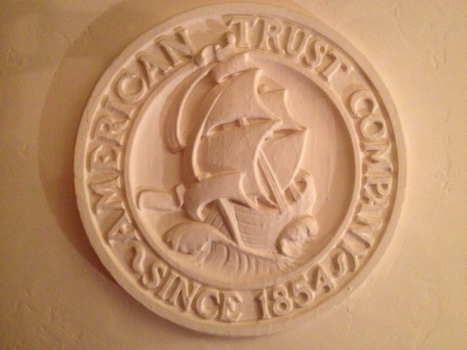
…which used to be a candy factory and shop, which used to be next to a kindergarten…
Explanatory historo-GIF below:

Individual years here, if you are not GIF-inclined.
-
- 1886 – 3299 Mission
-
- 1900 – 3299 Mission
-
- 1914 – 3299 Mission
-
- ~1950 – 3299 Mission
In addition to pizza being cooked at a temperature higher than the surface of Venus, PizzaHacker is bringing back the famed Intermezzo salad:
“I kept the wooden bowls, but upgraded the pedigree of the ingredients (all part of my evil plot to gentrify Bernal Heights)”
(Excellent subterfuge, PizzaHacker, most excellent (rubs hands together).)
Hey, did you know that PizzaHacker has an official house band? During his interview on Burrito Justice Radio (archives coming soon), PizzaHacker professed his love for 2 Lane Blacktop. I’d never heard of them before, but wow. Coming Home is particularly good.
To be fair, a) they are not really the official band, and b) the band broke up in the late 1990s, but goddamn I like them a lot. Hey 2 Lane Blacktop! You need to get back together and do a live show at PizzaHacker!
Anyway, welcome to the neighborhood(s) PizzaHacker! Hot may your oven burn, and cold may your beer flow.
La Controversia de La Lengua
It is a sad day, my friends. Mission Local reports:
Every revolution has its line-in-the-sand moment. For one architect south of Cesar Chavez, the moment came when locals — and even allegedly some city officials — started using “some hipster name” to refer to the neighborhood: La Lengua.
Mission Local recorded Harlan Hoffman’s constructive criticism:
- “That stupid name really got everyone listening.”
- “You would think the really hipster types would like it, but they didn’t.”
- “It’s not the Inner Mission, it’s not the Outer Mission — it’s its own thing,” Hoffman said. “We don’t know what to call it yet, but it will certainly not be La Lengua.”
Am I a hipster? So I am a hipster. I contain multitudes. Deal with it.
Harlan, here’s what you don’t get — La Lengua doesn’t care what you think. La Lengua just… is. We didn’t try very hard, and La Lengua took off. We are having fun.
You seem angry, Harlan. But the more you try to hate on La Lengua, the stronger it will become.

Here are some suggestions since you didn’t actually suggest any names to counter the mighty power that is La Lengua:
- Harlandia
- Hoffmanistan
- Mishlencia
- Valission
- Harlan’s House of Happiness
The tongue is pointed at you, Harlan.
GIF 1849a
I’d like to personally thank Samuel D. Humphrey for standing outside on the evening of September 1, 1849 and taking these daguerreotypes of the moon:
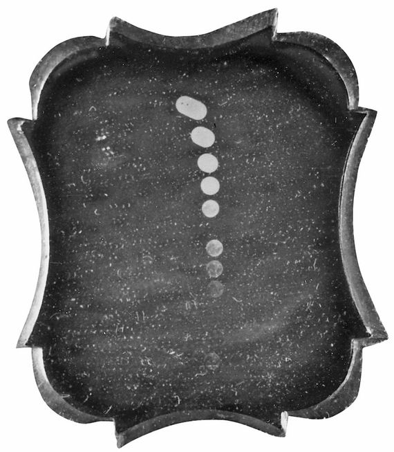
He was screwing around with different exposures, from half a second to two minutes. (Looks like 2 seconds worked out best, Sam.) For the record, moonrise that day was around 6:18 PM.
He would obviously have made this into a GIF, so here you go, albeit 163 years later:
More on present and past moontography here.
UPDATE: looks like 3 seconds was the best exposure:
The lunar surface in the three-second exposure was, as the Annual of Scientific Discovery noted, “so perfect, that its appearance, when examined under the microscope, somewhat resembled the full moon seen through a telescope.”
Steamships, Clipper Ships, Lego Ships, Space Ships
We here at Burrito Justice have a soft spot for infrastructure aquatic, and this map of worldwide steamship lines in 1914 fulfills this requirement.
https://twitter.com/Sjgray86/status/421221401572286464
Click through for the full version, but I took the liberty of highlighting the San Francisco routes for your viewing pleasure.

And in other shipping news, check out this rather awesome 1859 report on the progress of the US Coast Survey (PDF). Lots of information on San Francisco in the 1850s. A description of the conditions of San Francisco Bay starts at p.333, and p. 346 goes into detail on clipper ships:

The report also mentions what must have been mind-blowing travel times of the new steamships.

Here’s an ad for the Golden Age from the 11 Nov 1854 Daily Alta.

It seems that the Golden Age took over the Panama-SF route from the steamship SS California which had been making the run since 1849, leaving New York in 1848.
California left New York City on 6 October 1848 with only a partial load of her about 60 saloon (about $300 fare) and 150 steerage (about $150 fare) passenger capacity. Only a few were going all the way to California.[8] Her crew numbered about 36 men. She left New York well before definite word of the California Gold Rush had reached the East Coast.
The arrival of the California in December 1849 as reported in the Daily Alta:

A number of ladies and a large mail, oh my.
UPDATE: In 1849, it seems that “a number of ladies” is equal to eight:

I was surprised to learn that the Golden Age came to California from New York via Liverpool, the Cape of Good Hope and Australia.

May 1854 (reports from February)

Australian newspaper reports, and a lovely image via the National Library of Australia:

And its July 1854 arrival in Panama, with lots of details:

The backstory on the Golden Age, via the Maritime Heritage Project:
She was originally named the San Francisco and slated for service between Australia and Panama. She sailed from New York on September 30, 1853 and went via Liverpool, the Cape of Good Hope, King George’s Sound (Australia), and Melbourne to Sydney. She operated coastal service in Australia until sailing for Panama on May 12, 1854. Pacific Mail purchased her at Panama in August 1854 and used her on their San Francisco-Panama run through 1869. She was later transferred to the Yokohama-Shanghai branch of Pacific Mail. The Golden Age was sold to the Mitsubishi Mail Steamship Company in 1875 and renamed Hiroshima Maru.
She sailed in Japan until the 1890s where she was known as “the good luck ship“.
The sailings of the California and Golden Age are hopefully captured in this rather amazing map of world sailing routes from 1750 to 1860 made by Ben Schmidt.

And to wrap things up, I added the SS Golden Age to this infographic comparing the sizes the container ships of our era, via Quartz. While I couldn’t find the exact length of the Golden Age, its contemporaries seemed to be around 270 feet long, or about 80 meters.)

That Quartz article talks about two of my favorite things, ships and Lego. Lego made a number of floating boats, including one for Maersk. I of course had the firefighting boat and the police boat:


I still have these in a box at my parents house, along with my space Legos — you can see the red counterweight at the bottom:
I am telling you Lego, if you started selling those 70s Space Lego sets again, oh man, you’d make a million damn dollars.

I mean, I just bought the Mars Curiosity Rover:

BurritoBox
I just… oh, L.A., you make it too easy.
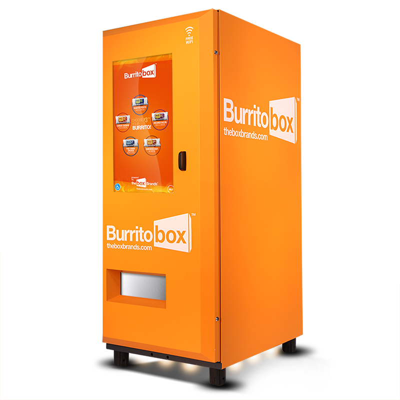
I am glad to see we have advanced our putting-a-microwave-in-a-box technologies to such orange levels. And free WiFi!
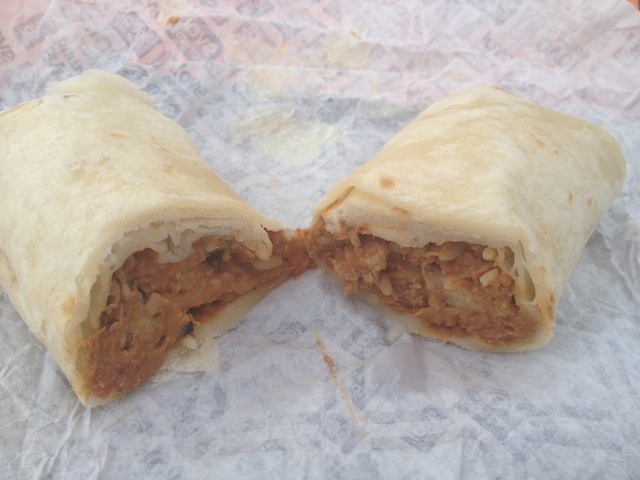
My heart sincerely goes out to the brave souls at LAist and Vice who actually consumed the burritos.
https://twitter.com/dave_schilling/status/420725893296693248
LAist actually tried all 5. Good god.
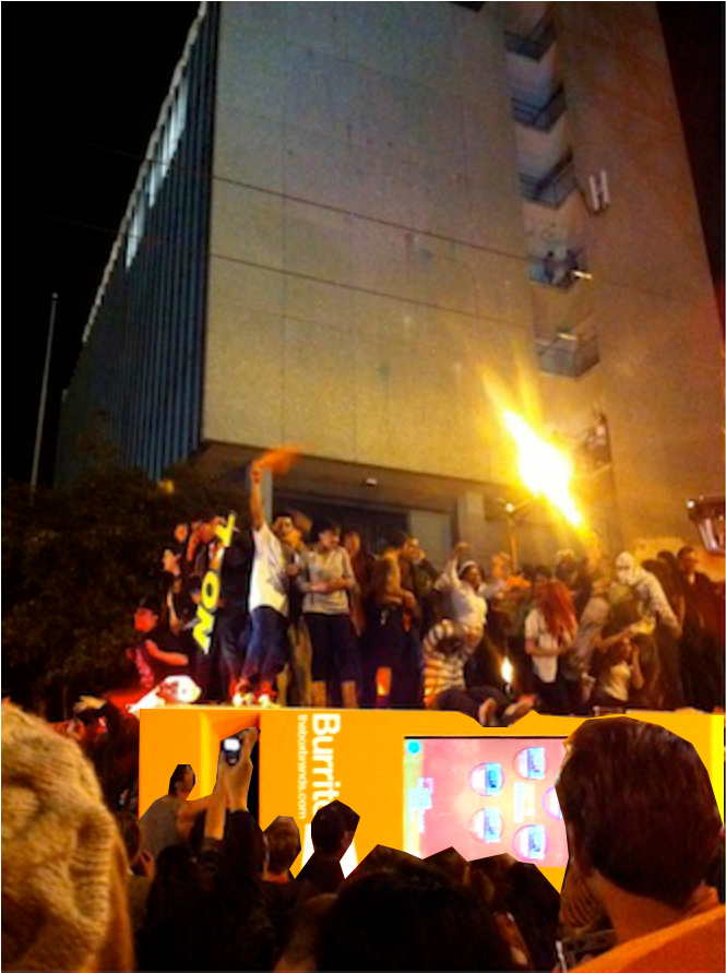
But will the Box Brand family be brave enough to move north?
https://twitter.com/emmagallegos/status/420776300144369664
It would imagine it would go something like this:
And lest ye forget, Los Angeles, we can disable “humanitarian mode” on the Burrito Railgun and eliminate any threats to the burritosphere.

Perhaps New York is a better spot for such finely machine-crafted burritos, as @ThePeterHa (212 AND 503 hahahahahhahahaa) seems to think:
Of course, this raised the question of what other things should be in vending machines. We have previously discussed the need for beer on Caltrain:
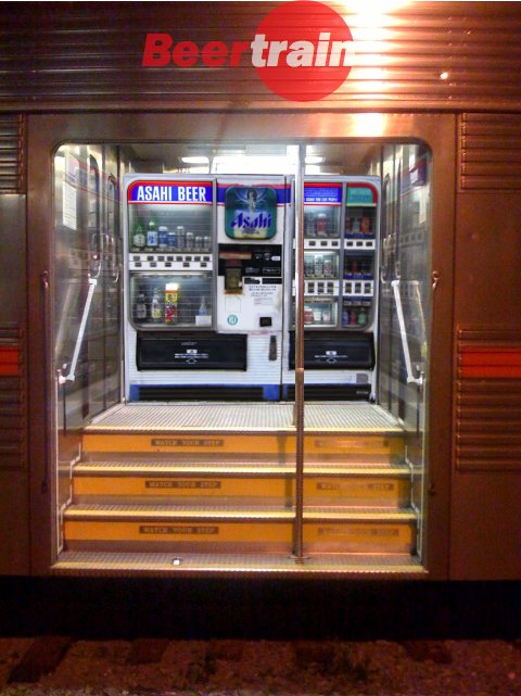
And hey, look, a vending machine that sells those micro-apartments! I’ll taaaaaake… the yellow one.
Sutro, Fog Catcher
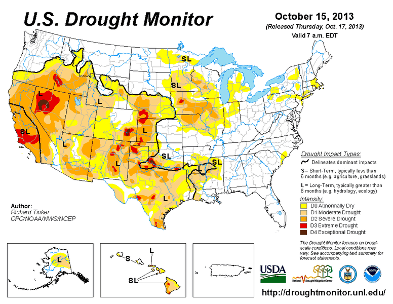
The drought, it is coming. Rainfall totals for various Northern California cities in 2013 via the Mercury News.

And drought GIFs, naturally:
The dog days of reservoirs.
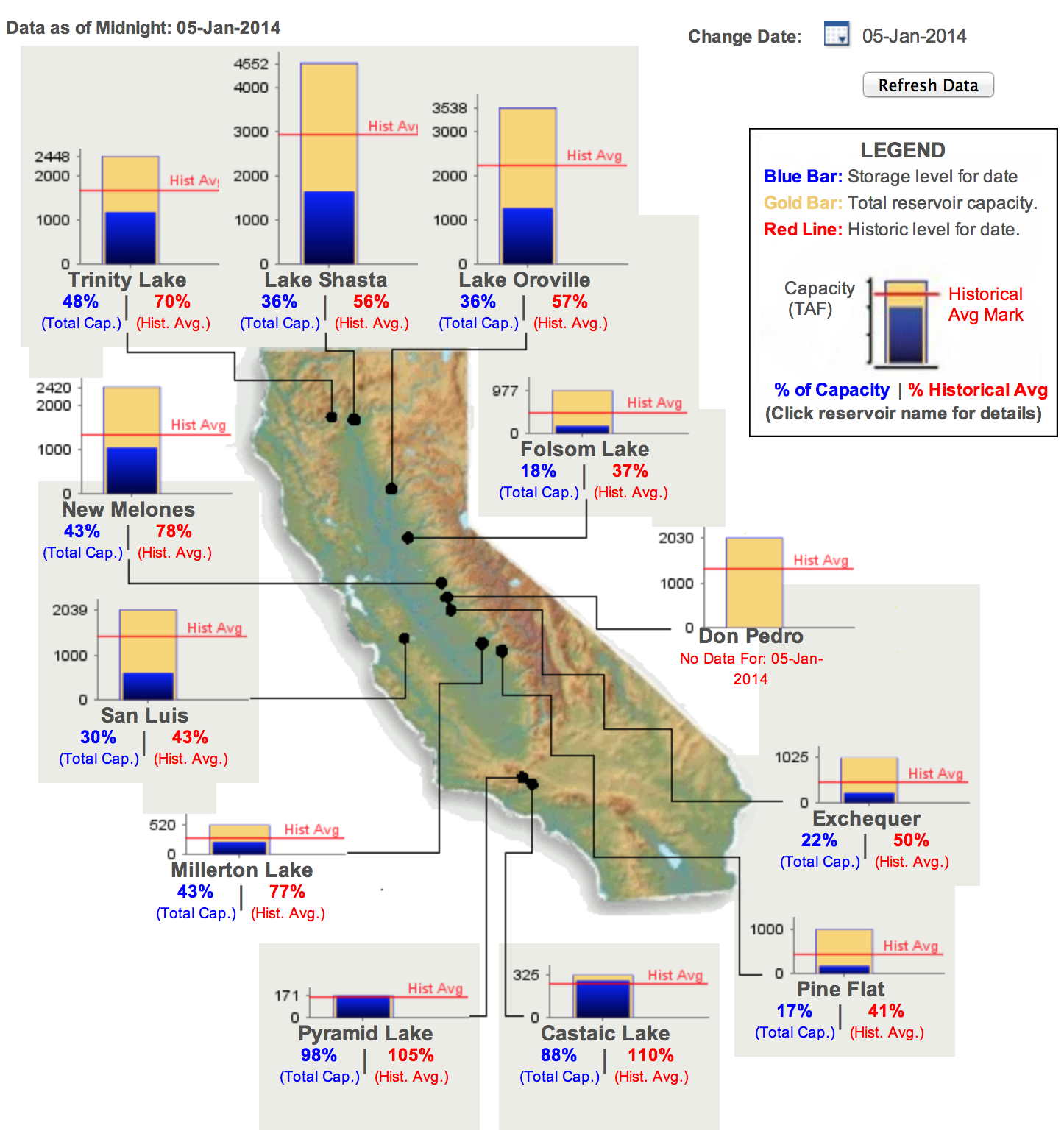
This is especially bad since we in California get the most of our water from the Sierra snowpack. Uh oh.
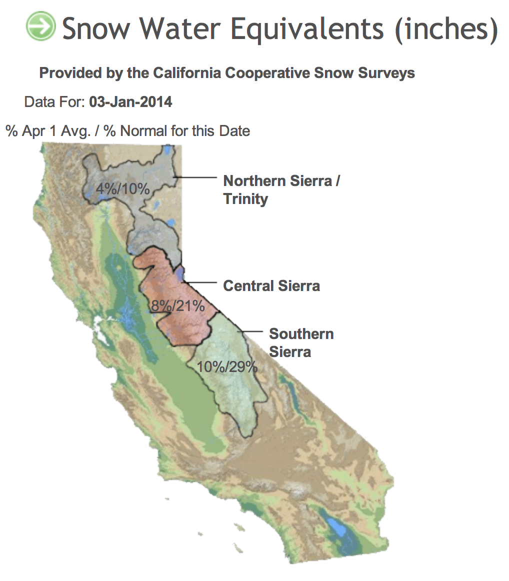
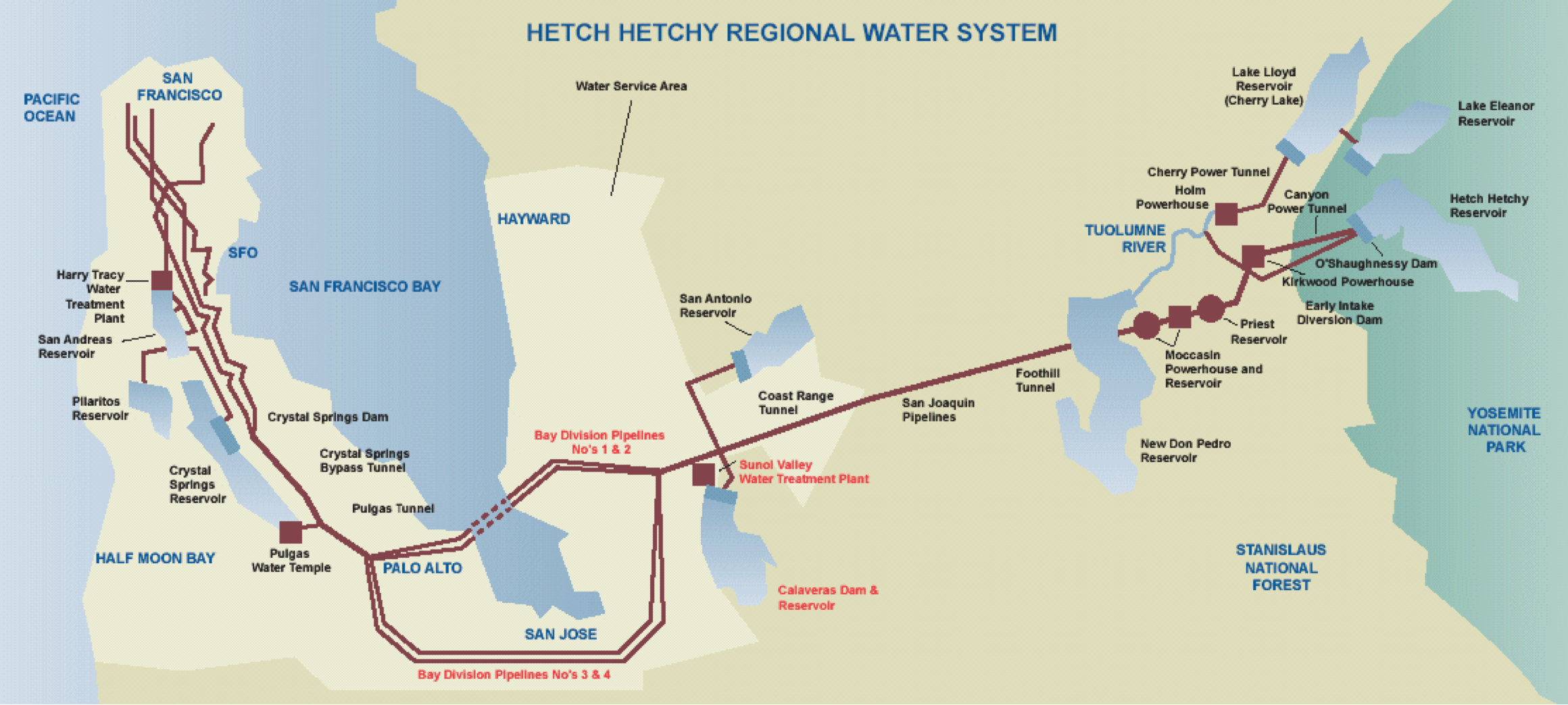
Hetch Hetchy is a geo-engineering marvel, but you have to start wondering what happens when the Sierras start looking like Baja California.
@mizmay reminds us that we actually have decent groundwater in SF.
https://twitter.com/mizmay/status/419967585547845632
These would be Islais, Precita and Dolores Creeks:
“the fresh spring waters indefatigably flowing on the eastern slopes of Twin Peaks are a wondrous geologic feature, of unknown origin and potentially great benefit to the city. This water comes in quantities and seasons unlikely to be associated with local rains. Further study is needed to determine its ultimate source.”
Of course, it’s always nice to have backups. This is why I demand that Ed Lee immediate tap the aquatic reservoir that is… @KARLTHEFOG.
There is a precedent to this in South America. Residents of Lima are building “Atrapa nieblas“, or fog traps. On a good foggy day they can capture 150 gallons of water.

We of San Francisco, being awesome, can do better than that. First some math. Fog contains anywhere between 0.05 and 0.5 grams of water per cubic meter. Karl, being Karl, is obviously 0.5 grams. Assuming half the city is covered in fog at a depth of 1000 feet (i.e. the top of Twin Peaks):
49 square miles / 2
= 63,454,700 square meters * 300 meters
= 19,036,410,000 m3 * 0.5 grams
= 9,518,205,000 grams = 9,518,205 kilograms = 9,518,205 liters = 2,514,440 gallons.
That’s a sphere of water 43 feet wide, or a cube 70 feet on a side.
Problem solved! OK, not really, as I do not have a realistic method to collect fog over half of San Francisco. However, a short term solution would be to retrofit Sutro into an atrapa nieblas:
Simulation of it in action:

(original photo via DailyKos)
A quick calculation shows that with a surface area of 300 by 300 meters, and a 22 mph wind (10 m/s), our modified Sutro could catch 100 gallons per sec.
Not too shabby, Sutro, not too shabby. If @karthefog is around for 12 hours, that’s over 4 million gallons!
UPDATE: Sarah Zhang wrote a great followup article over on Gizmodo about other fog catcheries:
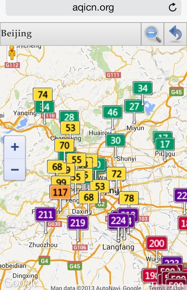
The AQI is Nigh
O woe, @karlthefog has forsaken us. Instead we get Karl’s evil cousin @snarlthesmog.
 |
 |
 |
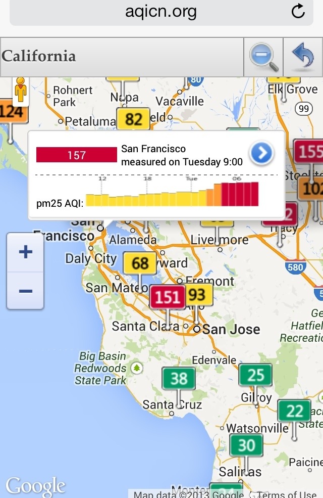 |
A bevy of mappable worldwide pollution data over at aqicn.org.
UPDATE: @ptraughber took a besmogged picture atop San Bruno Mountain this morning, and @couch provided a clear picture from the same spot which I aligned.


