Bikes to Books Tour! May 3, 1-4! Co-hosted by SFBC!
Saturday, May 3, 1pm-4pm: Bikes to Books Ride! (co-hosted by the SFBC)
Combining San Francisco history, art, literature, cycling, and urban exploration, this 7.1 mile tour wends its way from Jack London Street to Jack Kerouac, South Park to North Beach. Admittedly not for the faint of heart nor gear, this interactive bike ride is nonetheless a diverting and unique way to celebrate both the literary and the adventurous spirit of San Francisco.
- Meet at 12:45 p.m. at Jack London Street in South Park
- Ride will commence at 1 p.m. sharp
- Ride will end at approximately 4 p.m. in North Beach (outside City Lights Books)
- Bring bikes with gears, snacks, and enthusiasm
- Bike ride is free!
You can pick up a map for $5 at the start of the tour, or buy one at any of these fine literary establishments:
- Adobe Books (24th @ Folsom)
- Alleycat (24th @ Harrison)
- Modern Times (24th @ Alabama)
- Dog Eared Books (Valencia @ 20th)
- Needles and Pens (16th @ Guerrero)
- Borderlands (Valencia @ 20th)
- Viracocha (Valencia @ 20th)
- Green Arcade (Market @ Gough)
- Green Apple (Inner Richmond, 6th Ave @ Clement)
- Paul’s Hat Works (Outer Richmond, Geary @ 25th Ave)
- Other Avenues (Outer Sunset, Judah @ 44th Ave)
- City Lights (North Beach, Columbus @ Broadway)
If you are interested in becoming a distributor of these finely crafted maps, ping @enkohl. And if you want a unfolded map suitable for framing, contact @burritojustice.

Things are Brewing in La Lengua
Oh dear.
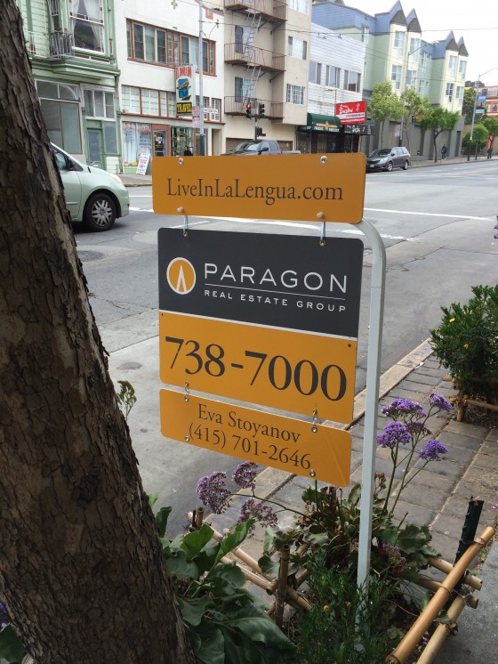
I’m not going to embed the link, for as TK notes:
Oh estate agents, this kind of nonsense is exactly why I made the damn name up in the first place:
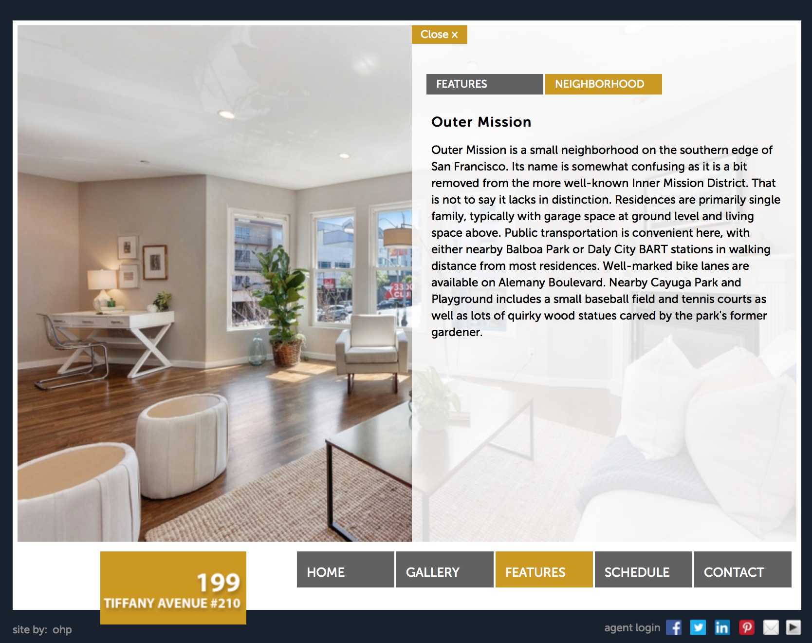
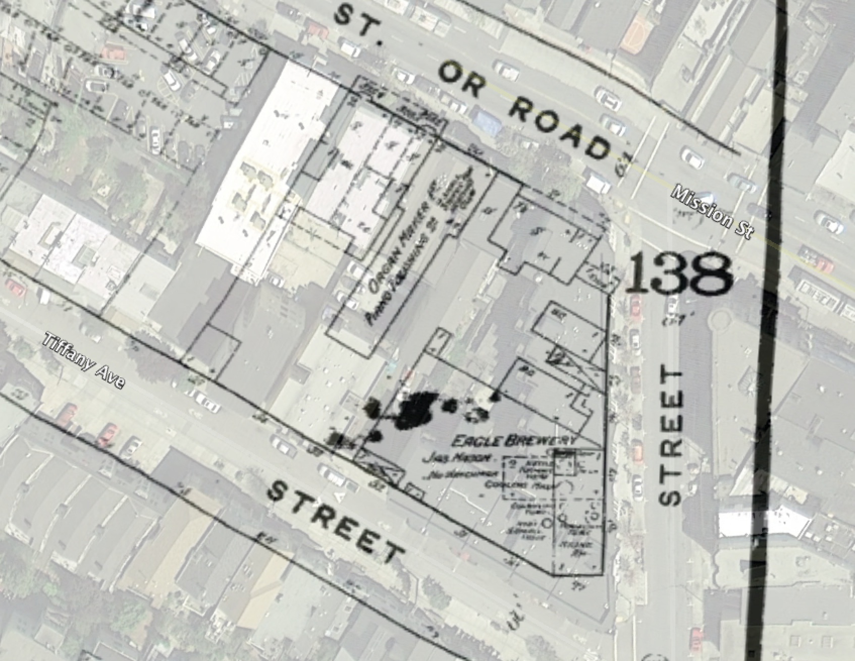
This is exactly the kind of thing that drives me to drink, preferably something from the Eagle Brewery which was on that very spot in 1886.
![]()
Big Hole in the Mission
When BART was built along Mission St, it was one of the first times a tunnel boring machine was used in America. (The construction history of BART is covered in utterly fascinating detail in this report preserved by Richard Mlyarick.) However, the stations were constructed by digging a giant hole, and then covering it back up. Here’s a photo looking north from 24th in the very 1970s via the esteemed FoundSF.

You can see the Bay View Bank / US Bank building on the right, and the Leed’s / Skechers sign in the background. El Farolito (which at the time was La Conga restaurant, right next to the Smile Awhile tavern) would have been just to the right. Compare and contrast to today:

Here’s a shot I just took out of a Muni window with a slightly different angle to make it easier to see past the trees:

A quick detour in which we play “what’s that sign“: Jay’s Liquor & Groceries is now painted a lovely shade of blue.

Zoom and enhance!

I can only imagine how that went down.
“Thanks Jay, enjoy your retirement!” [door closes]
“Excellent! Jay is finally gone! Go paint the sign!”
“OK!” [gets blue and white paint]
“C…R…Y…S…T…
…oh shit.”
While it doesn’t cover the Mission, this 1968 BART construction video is a classic. Oh the music!
And lest we forget, the epic Streets of San Francisco chase scene through the blue and green-tiled 16th St BART station and tunnels still under construction…
I am sure that during BART station construction people and businesses around 24th & 16th were upset, though I suspect the inconvenience of construction were outweighed by demographic changes and the suburban flight that were already well underway. For example, while Karl’s Shoes didn’t make it past 1972, but John’s Do-Nut & Coffee lasted until at least 1982.
But some people were very unhappy with the thought of how BART would change the neighborhood, as we can read in this classic Basta Ya! article archived by FoundSF decrying the changes that BART would bring to La Raza:
“The San Francisco Planning Department foresees 13,000 to 14,000 new residences in the next 20 years. Look around. Where will they find space to build 14,000 homes? The only place is on top of the home you are living in now.”
(If only they had built 14,000 units…)
“What else do the urban designers forecast? They see Mexican palm trees every 26 feet. An “historic” walkway up 16th to Mission Dolores lined with Taco stands and stores that sell genuine made (on Valencia St.) blankets and souvenirs.
Is Senor Taco the type of urban renewal we want? BART will bring tourists from downtown to 16th and Mission in three minutes. Our homes will become hotel rooms and restaurants and serape stores, and Topless Taco Clubs that do not serve Mexicans.”
To be honest I think a topless taco club might be an OSHA nightmare given the heat of the grill. (Also: do not google “topless taco” by image. Really. Just don’t.)
This early-gentrification piece ignores the fact that the neighborhood was Irish-Italian-Scandinavian before the siren song of the suburbs. But another classic is this 2000 SFBG piece written in the midst of the last dot com boom. Before we get into taquerias, here are some sobering numbers on house prices and rent in the Mission:
“According to a Mission Economic Development Association report, the neighborhood’s median home price jumped from $235,000 in 1997 to $381,000 in 1999, while average monthly rent on a two-bedroom rose from $1,330 to $1,678, and a square foot of office space shot up from $76 to $103 – all much larger jumps than in San Francisco as a whole.”
This claim about anglos getting chased out of taquerias in the early 80s was debunked by those there at the time:
https://twitter.com/periqueblend/status/453785169451679744
By the way, in 1980, El Farolito was inhabited by a place called El Burrito…

And while we’re on the subject, in 1981, proto-Farolito was Manuel’s, and in 1982 it had changed to El Zunzal.
Back to Basta Ya!
DIVIDE AND CONQUER
“Imagine a line up 24th St. from Potrero to Mission. Continue the line down Mission to 16th St., then up 16th to Mission Dolores Church. This line runs through the Mission community, tying it together. The two BART stations will break up this unity. With or without planning by the city the impact of BART will be to cluster activity around the stations on 24th and Mission and 16th and Mission. The new clusters will cut the community in two.”
This is an interesting point — I am not entirely sure where the “center of gravity” of the Mission was before BART, though given they originally planned a 22nd St station (and before that and Army St station, dammit (never mind 30th St…))


(both via Eric Fischer’s transit plan scans)
This of course gets into the future of transit. The recent acquisition of Safeway by Albertson’s got people on my Twitter feed talking about how to better use the massive parking lots. This usually came down to copying the Whole Foods model, with groceries below and apartments above. When BART was thinking about the 30th St infill/pocket station, the La Lengua Safeway parking lot was key in the construction plans.
The obvious conclusion is to convert EVERY Safeway, Whole Foods and Trader Joe’s in the city to a subway station and connect them with tunnel boring machines. This would quickly create a pleasing and most practical transportation network for San Francisco.

So don your hard hats, put on the reflective vests, and get thee to a tunnel boring machine!
But of course, we all know what the symbol for the new subway would be.

Pizzahacker Attacked by Runaway Streetcar! (in 1907)
So you are on 29th Street walking from Goood Frickin’ Chicken to Rock Bar when you hear a strange sound. You’d swear it’s one of the historic streetcars along Church Street and the Embarcadero, but… that can’t be right.
Suddenly @karlthefog lifts and tracks reemerge on 29th! The number 9 streetcar reappears!

The streetcar is hurtling down 29th St, but no one is on board.

The ghostly 9 rips past the Front Porch and the 3300 Club.

It’s going way to fast to make the turn onto Mission Street. It jumps the tracks and plows into Pizzahacker!
Other than the time warp, this is basically what happened in 1907 during a streetcar strike that was so violent, it was sometimes referred to as a war. The consolidation of private transit companies over the years led to poor service and the union went on strike for better hours and pay. (The strikes and crappy service eventually led to the creation of Muni a few years later.)
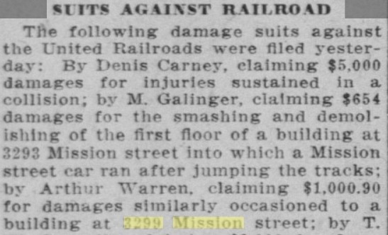
In short, a strike-breaking conductor and motorman were shot up the hill at Noe Street. While a second crew tended to the wounded, the gunmen sent their streetcar racing down 29th unmanned. It crashed into a candy store (where Pizzahacker stands today):
The injured men were taken in their own car by the crew that followed them to St. Luke’s hospital, the unmanned car being left at the top of the Twenty-ninth street hill. A person supposed to have been one of the three strike sympathizers who shot at the crew, started the car down the hill. “[The streetcar] sped over the six blocks between Noe and Mission streets, left the rails at the Mission street curve and crashed into the Mission Toggery and Warren’s candy store…”

More from the July 21, 1907 San Francisco Call:
[The conductor] heard a shot and immediately felt the pang of a bullet wound in his uplifted elbow… The man on the sidewalk near the front of the [streetcar] fired two shots and [the motorman] sank to the platform with a bullet in his thigh…
The car with the injured reached Mission street… but on the other track, car 1664 [was] gathering speed rapidly as its 26 tons of smoothly turning wheels came flying down the grade. Quickly the turn was made from Twenty-ninth street into Mission. Warning shouts were given and the crowd which was strolling in Mission street gave way to the green electric vehicle which came racing down the tracks.
With a bound the wheels of the runaway struck the flanges of the rails at the turn. The car swerved on the pavement. The trolley flew off. The car struck the curb and half turned, but could not he stopped and sidled over the sidewalk and crashed into the glass fronts of the stores.
The people In the store had heard the shouts in the streets and were turning to the door when they saw the car coming upon them with the almost animated ferocity of a dragon. They fled toward the rear of the store, but the car was too quick. Through the brittle glass and the thin wood frame the mad car smashed its way.

Here’s the 1900 Sanborn Maps site of the crash (and where Pizzahacker is today).
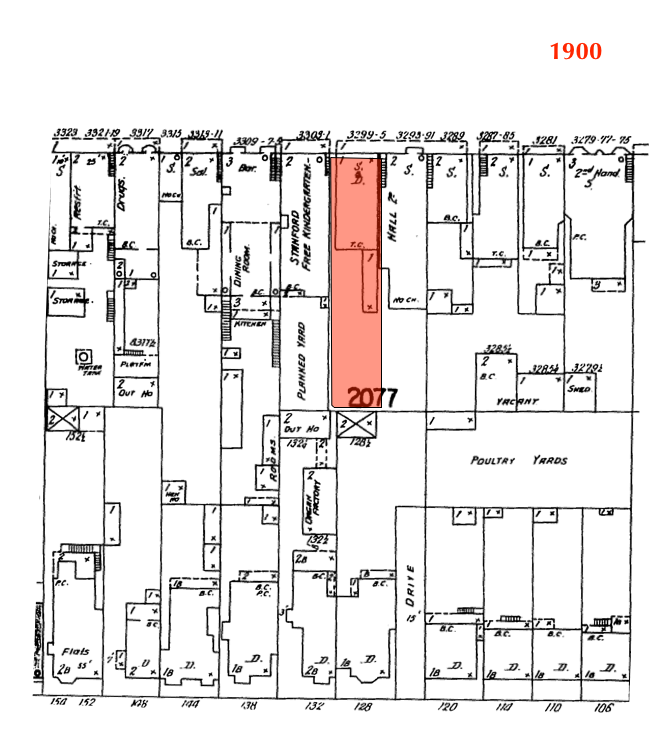
1900 – 3299 Mission
Here’s a GIF of the change from 1886 to 1950. The candy shop became a bank, probably in the 1930s.

And here’s the color Sanborn map from 1905. Looks like the kindergarten may have shut down by that time.

I’m not entirely sure if the lines were numbered in 1909 — those maps above are from the 1920s and 1940s. This one is from 1905, and seems to show destination names instead of numbers.

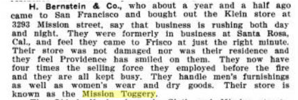
Here’s an ad from 1908 showing the Mission Toggery, “The Busy Store”. And the Lyceum! And Mr. McTigue!

In case you were wondering what a “toggery” was, it apparently sold “men’s furnishings, women’s wear and dry goods“:
Anyway, the crash led to no end of lawsuits.
@Pizzahacker is already looking to get in on it.
Калифорния Dreaming
Greetings Comrades! Russia is flexing its muscles following the absorption of Crimea.
A Russian legislator and friend of Putin actually sent letters to Poland suggesting they split the remainder of Ukraine in two. “It’s never too late to correct historical errors.”
(No this is not an April Fools’ Day joke.)
Until Seward and his purchase, Russia had a substantial presence in Alaska, so it’s not surprising that some there are calling for it back.
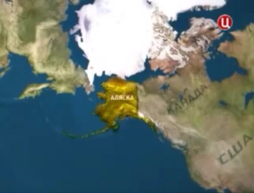
Hey look, California!
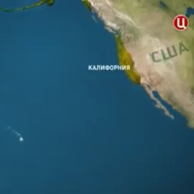
(Hmm, California seems to have gotten bigger…)
Historians and Beer-Americans will know the Russians had a colony up at Fort Ross from 1812-1842 until they gave it up and sold it to Mr. Sutter.
Of course we are ready for any Russian incursions:
But this has not stopped the dreams of a greater Russia by bloggers and TV personalities! Our agents in Poland have kept us up to date:
I mean come on guys you can’t argue with beregus.ru’s reasoning:
“Russians today live in Alaska and in California,” he continues. And these are “not emigrants of a new wave but the descendants of their glorious ancestors” who came and developed this coast. These people are trying to preserve their Orthodox faith and their Russian culture.”
Oh in that case sure, come on over.
“Discussions about the reunion of Alaska, and California with Russia is quite reasonable and fair. Alaska and the Pacific coast of North America – Russia Beach . Is not it time for us to stand firmly on its shore?”
Let us not forget they already have the maps:

The invasion would obviously look something like this but with less snow…
…and more sand:
Russia Beach!
This of course presumes that @karlthefog doesn’t get involved, like he did with Sir Francis Drake. And we all know Sutro would get in on it too.

Our Russian blogging friends continue:
“[Sitka] became the most powerful port in the Pacific. Even San Francisco admitted it was inferior to the capital of Russian America.”
WHAT YOU DID NOT JUST SAY THAT ENERGIZE THE BURRITO RAILGUN AND THE RING OF STEEL


I mean this is the second time Russians have dissed SF in the past few years.
“Vladivostok is probably better than San Francisco,” [Medvedev] said on Monday. “Nevertheless there are similarities that come to mind, because there is also an ocean, suspension bridges and the similar terrain.” In one last dig, he added: “Our people are definitely better.”
I just hope they don’t remember about the Russians buried on the hill.

But if anyone with an accent asks, they were probably Finns, not Russians.
And maybe we shouldn’t remind them that American troops were in Russia during the revolution after WWI (Archangel and Vladivostok).

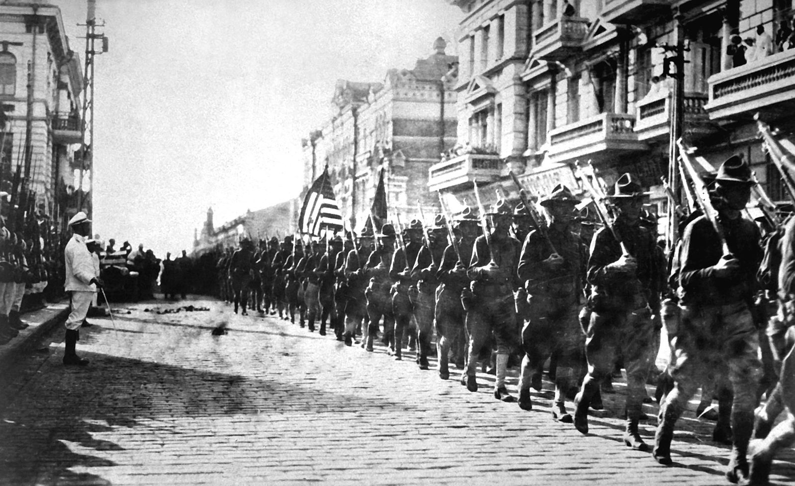
“American troops in Vladivostok parading before the building occupied by the staff of the Czecho-Slovaks. Japanese marines are standing to attention as they march by.”
And don’t get too smug, Canada and Japan and Poland and Czechs, you were involved too…

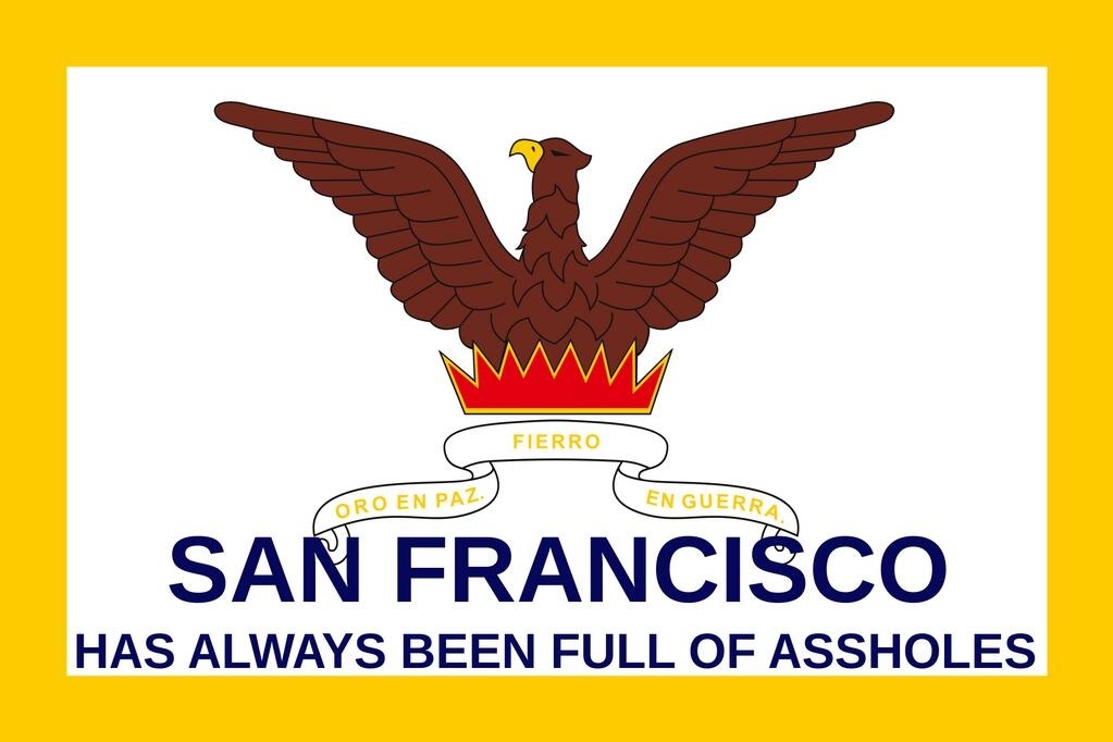
The New Flag of San Francisco
We have discussed San Francisco’s flag in the past. It is a flag for a city defined by fire. (BTW go read Black Fire OMG)
But just as much as fire, San Francisco is a city defined by assholes.
While the recent influx of Software-Americans has upset many, assholes have been moving into SF for the last 238 years. Spanish missionaries. American traders. Gold miners. Water lot speculators. Railroad barons. Bankers. Sailors. Prohibitionists. Anti-prohibitionists. Soldiers. Hippies. Assholes are not a new phenomenon here.
But despite this constant influx of asshatery asshattery, San Francisco has absorbed those assholes who chose to remain after their bubble burst, and the city has stayed interesting. I have faith that this pattern will repeat with the current influx, if we stay true to this advice:
…there is hope for the jerks, and framing it as a “tech” versus “anti-tech” dichotomy just sets up an “us” versus “them” dynamic that is not what’s going to turn them around. Instead, it’s a false dichotomy that turns *all* of us into jerks – and the Molotov’s situation is the perfect example. Light-heartedly calling out the jerks in their moments of jerkiness, so that they can recognize and improve their behavior, is very different from vilifying an entire industry that is made up of (mostly) good people. There have always been jerks in SF – well, at least since the Gold Rush — and there always will be. And it has always been the responsibility of good people to lead by example and not, by trying to teach the jerks a lesson, turn into jerks themselves.
I’d rather have a city that is interesting enough to attract assholes than one stagnating and in decline.
So thanks to the awesome @therealwbtc and the epic @40goingon28, and prompted by the magnificent @cjam…
https://twitter.com/TheRealWBTC/status/447103773958082560
…I hereby present the new flag for San Francisco:
Goodnight Clock
Most of you know Goodnight Moon, where a little bunny goes to bed. There are a number of subtle details in the Clement Hurd’s artwork that you only pick up on after reading the book several. hundred. times.
(FYI multiple updates on this post, check the bottom)
There’s the mouse, and the moon rising in the window, and the art on the walls referencing other Margaret Wise Brown books. And then there’s the clock. It’s something I gradually noticed over the past few years, and last night I decided, hey, GIF…
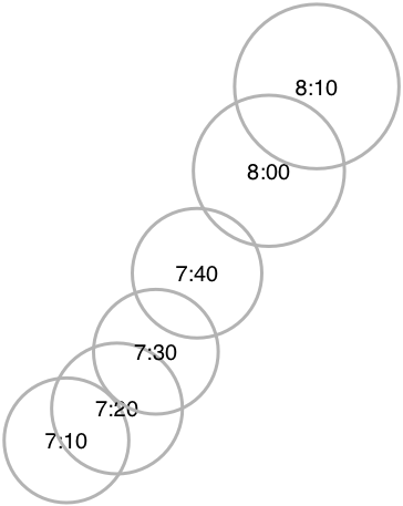
Turns out the little bunny bedtime ritual takes an hour and ten minutes, starting at 7 and lights out at 8:10, which seems about right.

Protip: If your friends are having kids, getting them Goodnight Moon (and/or a set of Sandra Boyton books) is always a good bet. If you *don’t* like them, or are in search of a retaliatory gift, get them the Melissa and Doug “Band in the Box” (which has nearly the same color scheme as the book now that I think about it…)

Incidentally a set of unpublished manuscripts by Margaret Wise Brown were just published! NPR interviewed Amy Gary who found them:
GARY: I was a young publisher and was looking for things that I could reprint of Margaret’s. And I was looking through all of these old books at her sister’s home. And her sister said oh yes, there’s this wonderful manuscript she was working on, but I’ve got it in the trunk and her barn. She was living in Vermont at the time. I thought, oh my goodness…
(LAUGHTER)
GARY: …I wonder if any of these papers are actually still left.
WERTHEIMER: Eaten by mice.
GARY: Yes. That was my first thought. So she opened it up one day for me and literally, the trunk is filled, end to end, with onionskin papers. They did smell, very moldy and old, but they were in perfect condition.
A dozen poems and songs are being published, along with a CD:
One of the lullabies is “The Noon Balloon.” At the end of her life, Margaret decided that she really wanted to focus on children’s songs and radio and television. It was a new way for her to reach children. “The Noon Balloon” was actually supposed to be a radio show. It would play in the middle of the day for a parent to let a child listen to songs and adventures.
After Margaret died of an embolism at the age of 42, her sister tried to get the manuscripts published for years with no luck. Amy Gary discovered these manuscripts back in 1991.
The author’s sister, Roberta Brown Rauch, tried to sell some of the stories in 1957; when no publishers showed any interest, she kept paper-clipped bundles of the more than 500 typewritten pages in a cedar trunk, where they remained until Amy Gary, publisher of Montevallo, Ala.-based WaterMark Inc., rediscovered them earlier this year.
(Any ideas why it took 23 years for these to be published?)
I however am not particularly interested in reading “Have a Carrot: Oedipal Theory and Symbolism in Margaret Wise Brown’s Runaway Bunny Trilogy” — Oh man that has got to be a dark read.
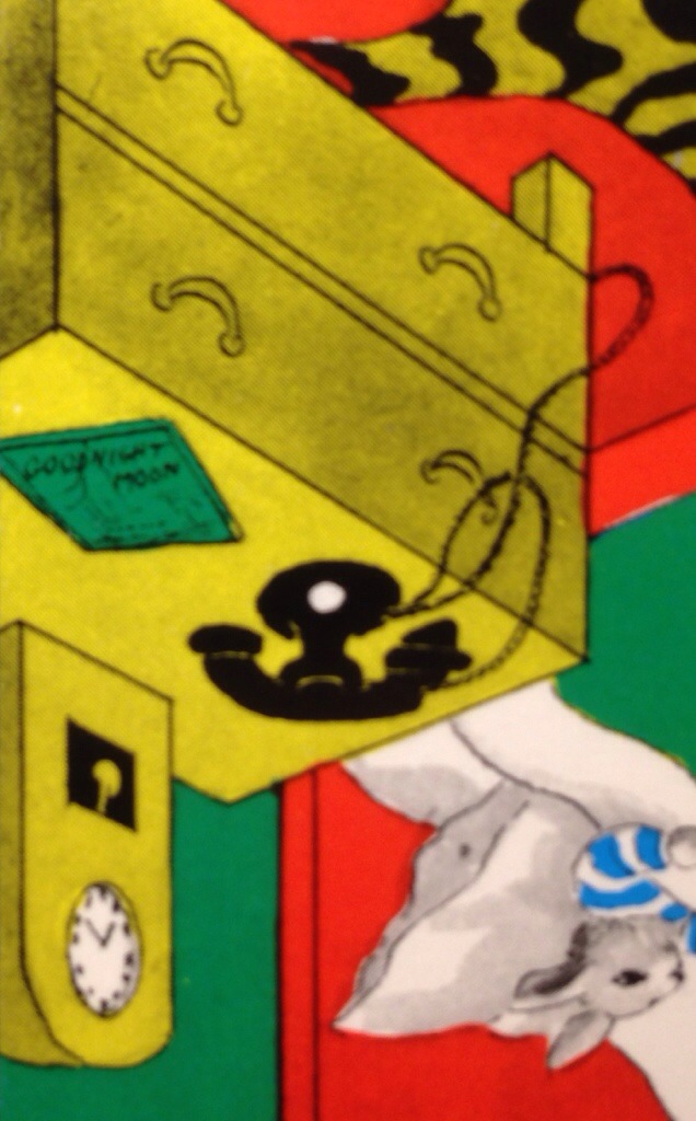
On a happier note, check out the book on the little bunny’s bedside table:
IMPORTANT ASTRONOMICAL UPDATE:
Several people on Twitter have harassed informed me that I should have calculated the passage of time according to the movement of the moon through the bunny’s window:
IANAA, but the moon is about half a degree wide as seen from the surface of the earth, and “rises” at 15 degrees per hour, or 2.5 degrees per 10 minute interval (i.e. per color page in the book). That’s 5 moon widths per page, or 35 moon widths for the story. (Do let me know if I got this horrifically wrong.)
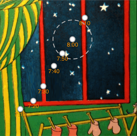
Here’s a GIF of the moon through the six pages it is visible:

The moon isn’t visible on every color page, and I didn’t get a time hack on each frame, and I did not bring my copy of Goodnight Moon with me today, but @geofflepper came to the rescue (yay Twitter!)
Breaking it down by time, we sadly see that the moon travels approximately half a moon-width (or a quarter degree) per 10 minute interval, not the expected five moon-widths:

What are Clement and Margaret hiding from us? Also, OMG THE MOON GETS BIGGER.
Maybe the bunny and the old lady are actually in a space elevator, getting closer to the moon as he gets into bed? Or as suggested by @transitmaps, the bunny can bend space and time? I do not have a good answer to this conundrum, but that is what the comments are for.
IMPORTANT ORBITAL UPDATE:
I decided to see how large the moon would have to be if it actually were travelling at the rate we expect, 2.5 degrees (or about five moon widths) per page. (I left the 8PM moon in there for comparison’s sake.)
Well, that’s not a very interesting children’s book. It would have to be renamed “Goodnight Window” I suppose.
But how close would the Moon have to be for it to appear as big as it does in the book? Geometry to the rescue! My math skills are rusty, but thanks to Wikipedia I remember that you can calculate the angular (apparent) diameter of an object if you know its distance and actual diameter,

specifically
Let’s say that the moon is 5º, or 0.0872 radians. Solving backwards from
0.0872 = 2 arctan (3,474 km / 2D)
we see that my (probably incorrect) calculations indicate that the Goodnight Moon would be orbiting at about 39,000 km, or 10 times closer to the Earth! For reference, that’s inside the orbit of geosychronous satellites at 42,164 km! (Yes, I should account for the angular diameter from the surface, not the center, but hey.)
Of course, if the Moon were 10x closer, it would be orbiting faster, and OMG the tides would be insane. (Sorry that I don’t have a number but can’t find a tidal calculator, though I believe the tidal power is a cube of the distance, so that can’t be good.)
The bigger question: is Goodnight Moon within the Roche Limit? That’s the point where the Earth would cause such extreme tides on either end of the Moon that it would break apart and Earth would have a ring, which would be cool except for the lunar debris bombarding Earth and even higher tides, both in the ocean and the crust of the Earth itself (and increased earthquakes and volcanic activity) as the Moon drew closer.
The Roche Limit for the Earth-Moon system is 9496 km, or in technical terms, pretty damn close to the Earth. My back of the envelope calculations indicate that the moon would be nearly 21º, or over 40x the moon’s actual angular diameter. Or as the little bunny would see it:

Goodnight tides
Goodnight air
Goodnight life everywhere.
Of course, this all presumes that the little bunny and the mysterious hushing lady and the cats that don’t catch mice are actually on the surface of the Earth, and not in orbit, but I leave that as an exercise for the reader.
IMPORTANT CISLUNAR UPDATE:
I have come to a rather startling conclusion, and it is either really good for the bunny, or really bad. As we previously mentioned, the moon actually gets bigger through the progression of Goodnight Moon. Here we see the relative increase in size from 7:10 to 8:10:

or more dramatically:
Working from our previous assumption that the Goodnight Moon is 10 times closer than our moon, the magic of arctan tells us that with the increase in its apparent size from 4 to 5 degrees in the space of in an hour, the moon has moved rather closer to the bunny’s room, from 49,000 km to 39,000 km.
Hey, no big deal, the Moon is just moving towards us at 10,000 km per hour, or five-sixth of the Earth’s diameter in an hour, BRB.
So if the Moon is moving towards the Earth, the little bunny has about three hours sleep before the moon is torn apart by the Roche limit, and four hours before another extinction event. But on the other hand, perhaps the bunny is in a spaceship with an awesome window and is moving *towards* the Moon. (10,000 kph is almost the same speed that the Apollo 11 astronauts were travelling at that distance on their way to the Sea of Tranquility.) That’s the story I prefer. And it’s certainly less intense than an alternative take on the bunny’s room that a Metafilter reader pointed out.
Also, WHOA:
Bernalonimbus
Cloud city indeed.


Skeletons Beneath Our Feet
You may have heard that a skeleton was found at the Transbay Terminal construction site, 60 feet down. “The agency said its archaeologists worked in coordination with the San Francisco coroner’s office and determined that the remains are of Native American descent.” 60 feet down is pretty old, especially when you consider that in the 1840s when Yerba Buena started booming, First Street once bordered the water.
How old? Well, in 1969, construction workers digging out BART found a skeleton 75 feet below Civic Center. Turns out it was nearly 5000 years old.
The top half of the skeleton was lost during construction, but from the remaining half archaeologists determined that it was a 24-26 year old female who may have drowned in a creek. @davely was kind enough to scan an 1972 article from California Geology journal which had this diagram:
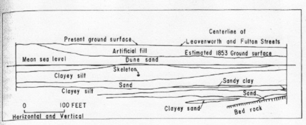
I took the liberty of redrawing the diagram in color, and stretching the vertical axis for clarity.
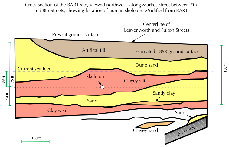
Archaeologists found both fresh and salt-water plant matter attached to the skeleton, indicating that our friend may have died in a creek or a marsh near the shore. She was found 26 feet below current sea level, which implies that sea level 5000 years ago was around that level.
San Francisco Bay as we know it is relatively new — as the ice age ended, sea levels rose dramatically. 18,000 years ago, to get to the beach you would need to take the N-Judah or the K past the Farallons, which were once hills by the sea. The Bay was a valley with a river running through it, and the Golden Gate was a waterfall.
Doris Sloan, Geology of the San Francisco Bay Region
San Francisco would have been Walnut Creek.
But as the waters rose the Farallons were cut off.
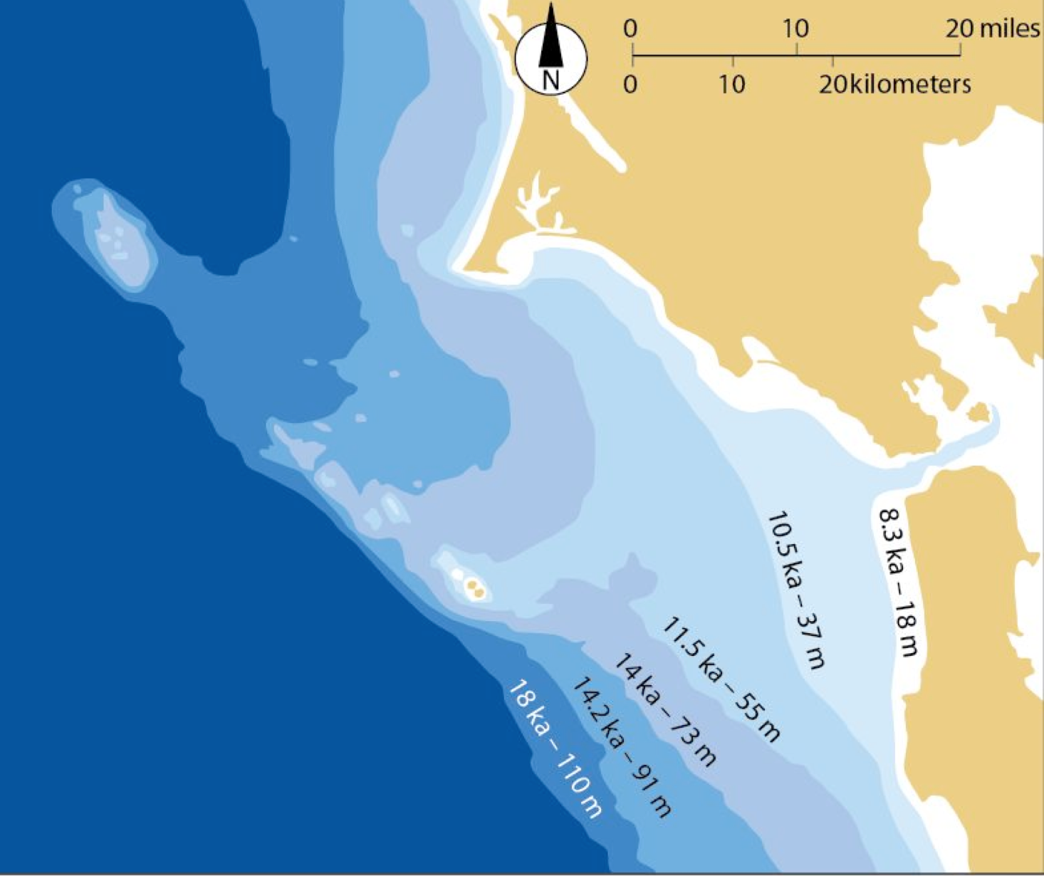
map via Late Pleistocene to Holocene History of San Francisco Bay, Prof. Lynn Ingram, UC Berkeley
These once were hills, separated only by sand dunes.

Around 10,000 years ago, the sea breeched the Golden Gate and continued to rise rapidly, filling the valley we now know as San Francisco Bay. There must have been settlements by the water — imagine each generation having to pull back, each high tide greater than the last.
In 1818, a Spanish missionary recorded some of the oral traditions of the Ohlone and neighboring tribes. One story went like this:
“What is now the port of San Francisco was formerly according to the tradition of the old ones an oak grove, and without water other than of a river that crossed at its foot, and in evidence of this tradition, they say you still find in the port and marsh, trunks and roots of oak trees.”
However, no known archeological site in central California appears much older than 5,000 years… One way to approach this problem is to assume that traces of the earliest central Californians have been covered by the rising sea. Given the rapidity of changes in sea levels and shorelines 5,000-10,000 years ago, sites of habitation located at that time along the shores of estuaries must now lie beneath mud and tidal water.
He asks:
How old, then, is the aboriginal tradition recorded by Mariano Payeras? If originated by people who actually saw the site of the Bay before widespread submergence, this tradition must be nearly 10,000 years old. Such antiquity, though improbable, cannot be ruled out.
Perhaps one day 10,000 years from now, archaeologists will find and decode flash memory that will reveal this map.

(Hi future archaeologists! Hope you extended BART and still have burritos.)
Bikes, Books, Beers, Benders
Do you like beer? History? Books? Why, I know you do or you would not be reading this blog. Then there is not reason not to join us at Benders on Wednesday, March 5 from 7 to 9 PM for the Bike to Books Beer Event!
We’ll be selling our rather awesome two-sided foldable maps for $5 American dollars (not adjusted for historical or future inflation). It’s like a Burrito Justice post that you can hold in your hand!


More on the maps here. See you soon! (Wear your Twitter handle so we know who you are.)
Bikes to Books Beer Social!
Wednesday, March 5, 7-9 pm
Benders Bar and Grill
806 S. Van Ness, SF
Join Nicole Gluckstern and Burrito Justice, the creators of literary bicycle tour “Bikes to Books,” for an evening of socializing, beer drinking, and map chat at awesome local watering hole Benders on Wednesday, March 5, from 7-9 pm. We’ll be talking up our collaborative map project including new developments, fielding questions, and enjoying some tasty adult beverages in the first of a series of “Bikes to Books” events and meetups planned for 2014.
Combining San Francisco history, art, literature, cycling, and urban exploration, “Bikes to Books” began as an bike ride homage to the 1988 street-naming project spearheaded by City Lights founder and former San Francisco Poet Laureate, Lawrence Ferlinghetti, in which twelve San Francisco streets were renamed for famous artists and authors who had once made San Francisco their home. First published in The San Francisco Bay Guardian and then in October 2013, with the generous assistance of City Lights Books, the physical map has been available ever since in many of San Francisco’s finest book emporiums, and is appropriate for use as a navigational tool, a history lesson, and a unique work of art in its own right.


