BART vs Freeway Retro-Futurism
November 7, 2009
Once again Eric Fischer makes blogging easy.
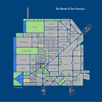
While this 1957 BART plan is impressive…

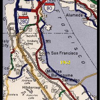
…or this detail of the proposed Geary Line…

…freeway drawings are so much sexier and distracting for long-term transit planning.
1964 plan for the crosstown freeway, Union & Lyon:

My, what a glorious and elegant Civic Center freeway exchange — life will to have been good!

9 Comments
leave one →


OMG they intended BART to go as far east as FAIRFIELD?! What a dream that would’ve been for poor high school me, relegated always to Berkeley because driving “all the way into the city” was so terribly difficult.
Oh how good it might’ve been.
There is a school of thought that believes that Caltrans intentionally made the Crosstown Tunnel look horrifying so that the Panhandle Freeway and Golden Gate Freeway would look appealing in comparison, and I am tempted to believe it.
The caption for the rendering of the interchange: “The architectural consultant feels that it would be difficult, if not impossible, to develop any sense of amenity or aesthetic values in this extensive and complex interchange. The many slivers of steeply sloping land will intersect each other making it impossible to develop the unified park-like quality possible at the Central Freeway interchange. He feels its proximity to the center of San Francisco government will isolate the Civic Center both visually and physically from large areas of the city.”
I’m constantly amazed that BART got built at all given the 50s freeway push. And I didn’t realize so much freeway planning was done after the first round of the revolts in 1959. But it does make sense that Caltrans saw the resistance and tried a perverse bait and switch in order to get their favorites through.
Turns out Jeff Diehl’s most excellent Spots Unknown hit the BART map Friday.
A Supervisor named Wm Blake (“the other Wm Blake”) had a plan to continue the EmbarcaderoFreeway to the Golden Gate Bridge in an underwater tunnel, with the only interchange being at the end of Van Ness. This was probably during the late 60s, though it could have been later. I’m not sure this ever went beyond being published once in the Chron. I also remember a map of a second Geary Blvd along the Turk/Golden Gate Ave. corridor.All the way to the beach, if I remember correctly.
If I’m remembering right, this map (from 1970) was for Blake’s plan: a long tunnel, but not underwater. Maybe he had multiple versions of the plan, or I’m remembering wrong, though.
There were aquatic alternatives for the Marina and Telegraph Hill legs of the 1965 plan, though.
If you ever find the Turk map, I’d love to see it!
“I’m constantly amazed that BART got built at all given the 50s freeway push.”
You shouldn’t be. This was, after all, a generation of planners that had built up shipyards and other military plants near overnight after Pearl Harbor, and whose Seabees had hacked out airfields out of jungles in the same World War, and applied their visions to civilian life postwar. This was also a generation that liked public works projects coming out of the Great Depression.
The planners of that era just liked building things, period.