Big Hole in the Mission
When BART was built along Mission St, it was one of the first times a tunnel boring machine was used in America. (The construction history of BART is covered in utterly fascinating detail in this report preserved by Richard Mlyarick.) However, the stations were constructed by digging a giant hole, and then covering it back up. Here’s a photo looking north from 24th in the very 1970s via the esteemed FoundSF.

You can see the Bay View Bank / US Bank building on the right, and the Leed’s / Skechers sign in the background. El Farolito (which at the time was La Conga restaurant, right next to the Smile Awhile tavern) would have been just to the right. Compare and contrast to today:

Here’s a shot I just took out of a Muni window with a slightly different angle to make it easier to see past the trees:

A quick detour in which we play “what’s that sign“: Jay’s Liquor & Groceries is now painted a lovely shade of blue.

Zoom and enhance!

I can only imagine how that went down.
“Thanks Jay, enjoy your retirement!” [door closes]
“Excellent! Jay is finally gone! Go paint the sign!”
“OK!” [gets blue and white paint]
“C…R…Y…S…T…
…oh shit.”
While it doesn’t cover the Mission, this 1968 BART construction video is a classic. Oh the music!
And lest we forget, the epic Streets of San Francisco chase scene through the blue and green-tiled 16th St BART station and tunnels still under construction…
I am sure that during BART station construction people and businesses around 24th & 16th were upset, though I suspect the inconvenience of construction were outweighed by demographic changes and the suburban flight that were already well underway. For example, while Karl’s Shoes didn’t make it past 1972, but John’s Do-Nut & Coffee lasted until at least 1982.
But some people were very unhappy with the thought of how BART would change the neighborhood, as we can read in this classic Basta Ya! article archived by FoundSF decrying the changes that BART would bring to La Raza:
“The San Francisco Planning Department foresees 13,000 to 14,000 new residences in the next 20 years. Look around. Where will they find space to build 14,000 homes? The only place is on top of the home you are living in now.”
(If only they had built 14,000 units…)
“What else do the urban designers forecast? They see Mexican palm trees every 26 feet. An “historic” walkway up 16th to Mission Dolores lined with Taco stands and stores that sell genuine made (on Valencia St.) blankets and souvenirs.
Is Senor Taco the type of urban renewal we want? BART will bring tourists from downtown to 16th and Mission in three minutes. Our homes will become hotel rooms and restaurants and serape stores, and Topless Taco Clubs that do not serve Mexicans.”
To be honest I think a topless taco club might be an OSHA nightmare given the heat of the grill. (Also: do not google “topless taco” by image. Really. Just don’t.)
This early-gentrification piece ignores the fact that the neighborhood was Irish-Italian-Scandinavian before the siren song of the suburbs. But another classic is this 2000 SFBG piece written in the midst of the last dot com boom. Before we get into taquerias, here are some sobering numbers on house prices and rent in the Mission:
“According to a Mission Economic Development Association report, the neighborhood’s median home price jumped from $235,000 in 1997 to $381,000 in 1999, while average monthly rent on a two-bedroom rose from $1,330 to $1,678, and a square foot of office space shot up from $76 to $103 – all much larger jumps than in San Francisco as a whole.”
This claim about anglos getting chased out of taquerias in the early 80s was debunked by those there at the time:
https://twitter.com/periqueblend/status/453785169451679744
By the way, in 1980, El Farolito was inhabited by a place called El Burrito…

And while we’re on the subject, in 1981, proto-Farolito was Manuel’s, and in 1982 it had changed to El Zunzal.
Back to Basta Ya!
DIVIDE AND CONQUER
“Imagine a line up 24th St. from Potrero to Mission. Continue the line down Mission to 16th St., then up 16th to Mission Dolores Church. This line runs through the Mission community, tying it together. The two BART stations will break up this unity. With or without planning by the city the impact of BART will be to cluster activity around the stations on 24th and Mission and 16th and Mission. The new clusters will cut the community in two.”
This is an interesting point — I am not entirely sure where the “center of gravity” of the Mission was before BART, though given they originally planned a 22nd St station (and before that and Army St station, dammit (never mind 30th St…))


(both via Eric Fischer’s transit plan scans)
This of course gets into the future of transit. The recent acquisition of Safeway by Albertson’s got people on my Twitter feed talking about how to better use the massive parking lots. This usually came down to copying the Whole Foods model, with groceries below and apartments above. When BART was thinking about the 30th St infill/pocket station, the La Lengua Safeway parking lot was key in the construction plans.
The obvious conclusion is to convert EVERY Safeway, Whole Foods and Trader Joe’s in the city to a subway station and connect them with tunnel boring machines. This would quickly create a pleasing and most practical transportation network for San Francisco.

So don your hard hats, put on the reflective vests, and get thee to a tunnel boring machine!
But of course, we all know what the symbol for the new subway would be.


As a techie anglo gentrifier who’s live in the Mission since ’81, I’d say its true that many of my friends were too chicken to come visit in the Mission back in the ’80s, and there was a real demarcation where the same chickens were really unwilling to venture east of Mission Street, or anywhere down 24th. Their fears, especially for our gay friends, were not baseless. Youths hanging on 24th street could be pretty menacing, with a heavy dose of homophobia — up until relatively recently.
But it was definitely not true that there were none of us, or that we were chased out of the hood. Far from it.
I always wondered where exactly the BART route is located, once it leaves Mission Street and continues to Glen Park. I guess they did not do an open dig through the Bernal Cut, and instead tunneled under Chenery Street: https://flic.kr/p/7F7Kqg
There seem to be no modern maps anymore that indicate the exact location of underground structures. Thanks, 9/11.
I have wondered this, too! When I get on at BART, I almost feel like it’s just magic that I arrive anywhere else. I’ve wondered if they put that information in real estate disclosures, though?
As an aside, my better half and I refer to the 30th Street BART station as if it’s already built, or about to be.
Added some of the construction history.
http://sonic.net/~mly/www.geolith.com/bart/
This is a little bit of a non-sequitur, but the pre-BART comments reminded me of when I used to live near the BART track right-of-way between the Pleasant Hill and Concord stations, and I had a lot of retiree neighbors who had lived there before it was built. When our next-door neighbors bought their house, the sellers had disclosed the planned track construction, and my neighbors’ reaction was, “Ha! We’ll believe THAT when we see it!”
But anyway, even out in Contra Costa County, my understanding is that there was a lot of concern about the changes that BART would bring, but people were mostly super excited about the prospect of getting to SF without having to drive 25 miles!
(Super interesting historical information, as always! Thank you!)
Does the person who wrote this live in Bernal Heights or what? That 30th St hub makes it look like the center of all SF.
You say that as if it weren’t.
Reblogged this on beauty of nathure.
Bayview Bank, not “Bay Bank”
Any idea how the section from Market connecting to Mission was tunneled? I know it goes directly under some buildings that are older than the tunnel.
Oops, yeah. Bay View. Thanks.
Take a look at that engineering report I link to, think it’s in there.
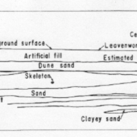
I think this is what you were looking for:
http://sonic.net/~mly/www.geolith.com/bart/#16thstreet
I will say that “S” symbol for the subway bears a strong resemblance to the logo of the Berlin S-bahn.
There’s some irony that the 1968 Bart Promo Video Song “We’re building a better tomorrow” is so stylistically close to Malvina Reynolds “Little Boxes”
Whoa. http://www.youtube.com/watch?v=2_2lGkEU4Xs