Treat Treatise
Tanforan cottages, you have met your match. Mission Loc@l reports on the discovery what is perhaps the oldest house in San Francisco at 1266 Hampshire (between 24th and 25th), dating to 1849. It has been traced to the brothers John and George Treat, whence the street name came.
“The house on Hampshire, historians said, was likely built in 1849 — the year a pair of influential pioneer brothers arrived in San Francisco — or 1850.” It was identified during the city’s South Mission Historic Resources survey.
Gregory Thomas of Mission Loc@l does a fine job referencing maps, but he makes the rookie mistake of stopping with the 1861 Langley map in the search for Treat. But going back to the 1859 US Coast Survey map, we can see the Treat compound at its original wonky angle, next to their Pioneer Race Course.

“Historians believe the house was lifted and moved about 100 feet east of its original location as streetcar lines were extended into the Mission –- reoriented to comply with a grid-style layout as the neighborhood took shape.” The concept of lifting up and moving a house simply blows my mind.
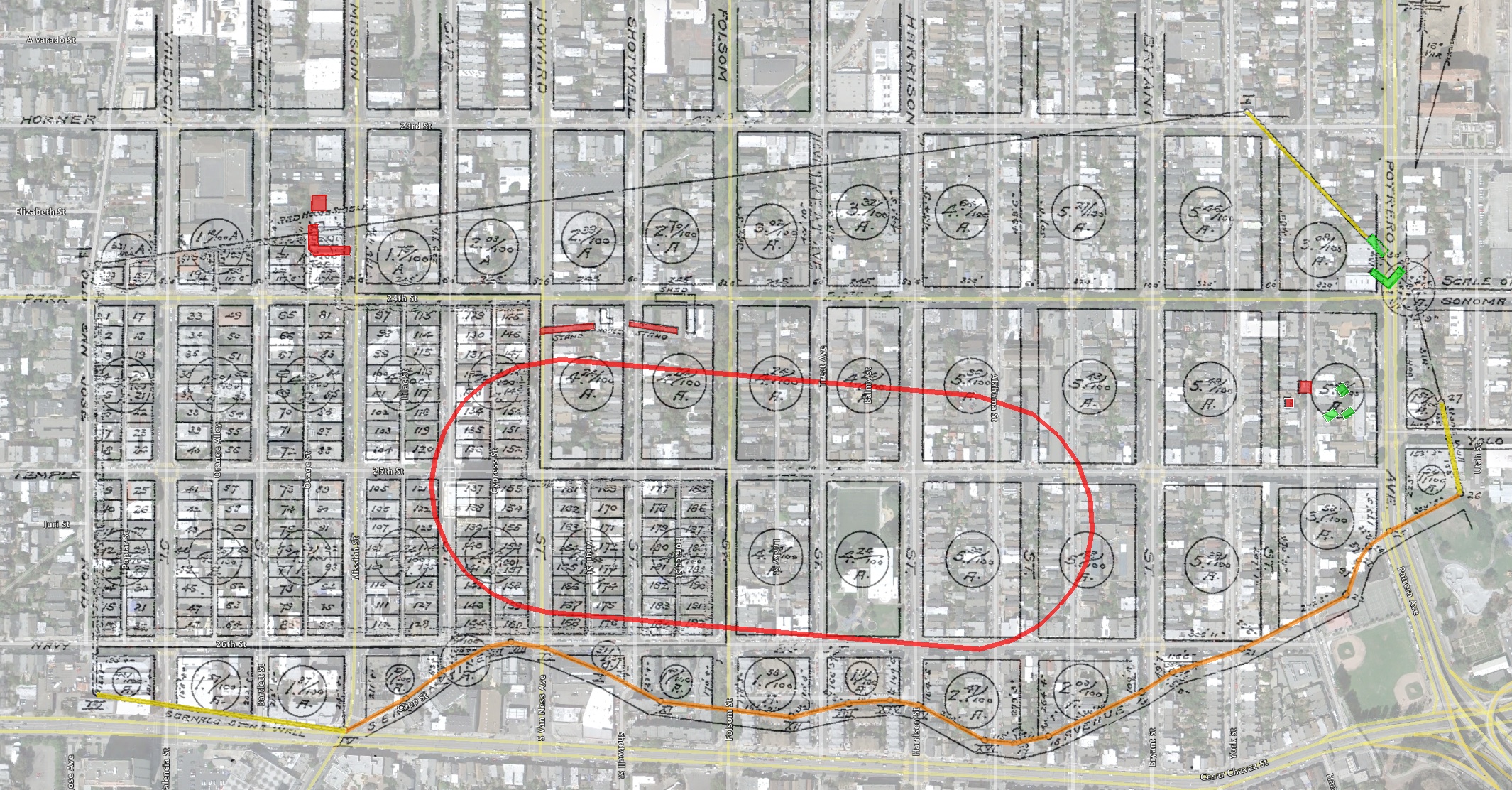
It seems like that block of three houses (marked in green) are the Treat compound. Red is the “new” position at 1266 Hampshire. The red arc is the edge of the Treat’s Pioneer race course, about 300 yards away.

(Google Earth rant — make sure you frequent save your Places. Apparently Google doesn’t believe in autosave. GE crashed and I lost about 15 hours of work on maps. Ripshit doesn’t begin to cover how I feel right now. Someone please make me an HTML5 based map/image overlay tool, OK? (Hint hint ,Stamen.))
Anyway, rant off. The San Francisco County Recorder’s office has ridiculously detailed maps of the land tracts and subdivisions through the history of the city. (Warning, not friendly to browse. A/B/1/2/3 are the oldest sets.) Here we see the 1864 submission for the “Pioneer Race Course Tract” (click to zoom):

Some fascinating details in the text, describing the lands belonging to George Treat and his neighbors in the 1850s:

And of course, the requisite Google Earth transparospinoverlay (click to zoom):

Zooming in on the Treats – the three green squares indicated in the 1859 Coast Survey map are probably their original buildings. The smaller red square is 1266 Hampshire — it looks like a second larger building also seems to have been moved once the street plan became apparent. I’m guessing they moved the houses sometime between 1857 and 1862 (when the Coast Survey Map and Pioneer Tract map were surveyed).

Other interesting details:
- the red oval is the Pioneer Race Track and the upper orange line is their path to the track — it went all the way past the grandstands (to the south of 24th, between Folsom and S Van Ness) to Mission
- the lower orange line is the boundary between the Bernal Rancho and Potrero Viejo (aka Mission Dolores)
- the yellow lines are stone walls marking the boundary to Portrero Nuevo (aka Potrero) — from the surveyor’s text, it seems that the green buildings at Potrero & 24th once belonged to “R.J. Perkins”
Looking to the west towards the road to San Jose, we see more interesting things:

- Bernal’s stone wall (more on that in another article)
- Serpentine Road, i.e. the northern border of the Bernal Racho above Precita Creek
- Capp next to the now historic Palace Steak House is one of the last remnants of Serpentine — hey, how about making that whacked corner and parking lot an history park?
- the Pioneer grandstands, theoretically pictured here:

In 1924, Anita Day wrote a history of the city in the San Francisco Bulletin that I touched on this in my Mission Baseball post. The amount of detail of the Mission is stupifying — she makes mention of the Treats:

(More on the Nightingale and bars of the 1850s in another article.)
A few pages later, she interviewed the son of Will Shear, the founder of the “pear shaped” Union Race Course:

Looking at the map, you can see a place on the NW corner of 24th and Mission called the “Red House”. But then we come across this ominous reference:

This of course explains all the ghosts floating around Payless Shoe Source. ¡Fantasma de los Zapatos Baratos!
(Note I entirely avoided any Treat related Halloween puns throughout this entire article. You are welcome.)
While we’re looking into the neighborhood, anyone know the story behind the wood shingled apartments on the NE corner of S Van Ness and 26th?

They kind of look like stables, and straddle the end of the 2nd (SE) turn of the Pioneer race course, just above Serpentine’s ghost.

First reference I see of them is the 1914 Sanborn maps.

Wondering if the architect had a sense of history.
UPDATE: Jonathan Lammers, architechælogist, lets us know in the comments that “The Arts & Crafts cottages at 26th and South Van Ness were developed by the T. B. Potter Realty Company in 1905. They are now San Francisco Landmark No. 206.”


This is so many flavors of awesome. Great work, sir!
Yeah this is truly fantastic.
If you think your wife hates your blog now, wait till you give in to our demands and write a book!
The recorder map URL allows you to select a map and then it can’t even find the directory the maps are purportedly under. Do you have any idea where they’ve stashed them? Under a desk?
Mary Brown, who works for the Planning Dept. as an architectural historian, had taken me to see that building some months ago as probably the oldest building in the neighborhood. What a delight to benefit from your fantastic sleuthing and map-mashing! Awesome! Can we throw this into FoundSF? It’s such a perfect addition!
Of course!
Nice work on the maps! I served as the field survey coordinator for the South Mission Historic Survey, and this entry reminds me of what my computer desktop looked like for the better part of 18 months.
Couple things: The Arts & Crafts cottages at 26th and South Van Ness were developed by the T. B. Potter Realty Company in 1905. They are now San Francisco Landmark No. 206.
Also, you’ll note that the boundaries of the Union Racecourse as described by Anita Day encompass many of the oldest (pre-1869) buildings located within the boundaries of the proposed Shotwell Street historic district. The clear inference is that when the track was closed, the land was immediately sold for development.
I’m also glad you’re interested in San Francisco’s incredible history of house moving. I only began to appreciate how common this was during the course of the survey, when I kept finding 19th century buildings that weren’t showing up on their lots until the 1914 or 1950 Sanborn map series! (I subsequently became aware of at least two house movers–also shown on Sanborn maps–who had their shops in the survey area). Then a friend pointed me to a wonderful article written by local historian, Bill Kostura, called “Itinerant Houses: A History of San Francisco’s House Moving Industry,” which appeared in the Argonaut (Vol. 10, No. 1 Spring, 1999). It’s clear from his research that moving houses was not only common, but that there was almost no limit to the size of what could be moved! (The photo that Greg Thomas included with his story on the Treat house is a scan from the Kostura article that I sent to him).
In any event, great work, and I really hope to have a chance to sit down and enjoy a beer with you and Eric Fischer some day. I’ve been a fan from afar for quite some time.
Thanks! And appreciate the pointer to the Arts & Crafts cottages, been wondering about that place for years.
Love to meet for a beer! Maybe Shotwells? Will drop you a line.
Just found this writeup of one of your tours – doing another soon?
The tour was for the AIA Architecture in the City Festival, but I’d love to do another — formal or informal. I was just cloistered inside working on that survey for so long that I barely had time to get out on the weekends.
Shotwell’s sounds great. Drop me a line anytime.
you guys are killing me. I live in those cottages (on Virgil) and I work at Shotwell’s. How can I get in on this beer action?
Great research!
Here’s a photo of a house being moved circa 1900:
http://www.sfgenealogy.com/sf/history/hgoe64.htm
Love the photo of the house being moved. Contractors still use cribbing as seen in the photo. I recall the recent work on the freeway through SOMA had tons of it. It makes sense to move a house instead of tearing it down. Houses are expensive and labor and time consuming to build. Relatively speaking, jacking it up and moving it is cheaper and quicker.
Hey that’s my place just left of the cottages! I made it on BJ! ;)
Hey, what’s the story on this car?
If I remember correctly, this guy/gal kept getting their car broken into and so they decided to make it publicly known. At least that was the word on the street.
Those are the Howard and 26th street cottages. I live there (until the end of the month at least).
http://www.sfcityguides.org/public_guidelines.html?article=202&submitted=TRUE&srch_text=&submitted2=&topic=Buildings%20and%20Theaters
Great post as usual!
Speaking of the Tanforan Cottages, when do they actually show up on a map? Though supposedly built in 1852-3, they don’t show up on the 1859 Coast Survey. Unless they were moved…
love the house moving info and pics. There were a bunch of houses moved from what is now the Upper Noe Rec Center. would love to find more pics of those houses and where they went.
My husband and I were turned onto your website by a new friend, who told us about the Treat House on Hampshire Street. We live a couple blocks over on Bryant between 25th and 26th. Such an amazing article! One correction, though–you say 1266 Hampshire is between 25th and 26th; it’s actually between 24th and 25th unless I’m mistaken.
Thanks! You are correct, streetlexia corrected.
–here’s another!
http://imgzoom.cdlib.org/Fullscreen.ics?ark=ark:/13030/kt6v19q1g3/z1&&brand=oac4
118. House Moving in San Francisco. [1860s]
By the way, I have a copy of the Map of the Perkins Tract (surveyed by John Center, 1863) if you want. Might make a good accent to this well-crafted piece.