San Francisco Archipelago
March 20th, 2072 (AP), Northern California Association of City States:
With the surprising acceleration of sea level rise due to the melting of both the Greenland and Antarctic ice sheets over the past decade, the San Francisco canal system was officially abandoned this week. Additional ferry service has been announced between the new major islands of the San Franciscan Archipelago while the boring machines make progress under the Van Ness Passage and Richmond Pass for new transit tunnels.

UPDATE: the NCCS (Northern California Coastal Survey) has made posters available.
Street Map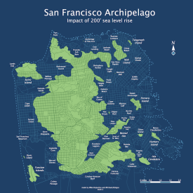 Order poster or wrapped canvas on Zazzle |
Topo map Order poster on Zazzle |
Street detail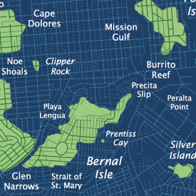 |
Topo detail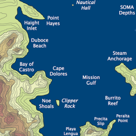 |
Unlike most coastal areas of the former United States, the population of the archipelago has dramatically increased despite the 200 foot rise in sea level over the past 60 years. Pundits debate whether this is due to the increasingly tropical temperatures or the creative and cultural explosion due to density. Regardless, the 4 million people now living on the SFA are demanding expansion of the San Andreas airport — studies are underway to build three more runways on the former 280 right of way.
However, the new class of supersonic Clippers will be in service by 2074 and Pan Am claims they can provide direct service to both Haight Inlet and Excelsior Lagoon, much to the relief of the Juniper Serra Conglomeration. (The JSC clearly prefers repurposing the old road to construct a rail gun space launch system with the help of Stanford Alto.)
The cruise ship berths along Divisidero Harbor continue to be upgraded, while negotiations are underway with Port Orinda and Caldecott Harbor to handle the cargo from the outdated facilities at Geary Sound. With the addition of the 6th high speed rail tube to the mainland, the original tunnels (completed in 2025) will be dedicated to cargo.
Development of high rises along the Sunset Coast and Cape Dolores has not been without controversy. The SHSFPA (Submerged Historic San Francisco Preservation Association) has once again protested and filed an environment historic review. “Old San Francisco is still alive in our hearts and minds, even if only the tops of the buildings can be seen! Look at the Flickr archive! ¡Viva Valencia!” While the SHSFPA frustrate many, all agree that their work floating Victorians and Italinate era homes and converting them houseboats has been a grand success, and has fueled a tourist boom along the Noe, Bernal and Dolores docks. The historical reenactments of life in the Mission District of the early 21st century have proven particularly popular.
While the submerged ruins of the Sunset and the Mission have always been popular diving attractions, many have already forgotten the locations of long-flooded streets and avenues. The SHSFPA recently published this overlay map showing early 21st century streets (double-blink to zoom, triple-blink for 3D):

While other islands have embraced both bridges and tunnels — the 150 year old bridges across Glen Narrows are scheduled for destruction once the new suspension bridge to Bernal Isle is complete — Potrero Island continues to be a holdout. Residents have yet again rejected the bond measure for a floating pontoon bridge crossing Beronio Reef and Market Shoals. Ask any Potreran and you will get the same response: “We were the first island, and we will be the last island. The cable gondola to Sutro Tower and Bernal is too much as it is.” Unfortunately, with sea levels increasing, they will very likely be flooded out by the turn of the century as this animation shows (GIF2023 support required, gesture for higher resolution holograph):

Is the future of the San Franciscan Archipelago doomed? Some environmental experts from the NOAA in the Washington DC SeaDome think so. “With sea levels continuing to rise at over three feet per year, the continued investment in the Archipelago is foolish. The failure of the Los Angeles seawall in 2049 is proof of this. And just look at the projection at 300 feet. Potrero’s all but gone and Bernal Isle is cut in half.”

As usual, San Franciscans are undeterred. “We won’t let those waterlogged Morlocks who pretend the United States still exists try to tell us what works. Even if we have to build a dozen more mile high Sutro Towers, we will stay here. We’ll anchor a floating city to the serpentine and chert if we have to.”
SF topological map via the most excellent Urban Life Signs. It turns out they were also working on a 25 foot sea level rise map, something we could very well see in our lifetimes.
Potential Sea Level Rise from melting ice caps:
- Greenland: 6.6 meters (21 feet)
- West Antarctic: 8.1 meters (26 feet)
- East Antarctic: 65 meters (213 feet)
120,000 years ago, SF Bay was 20 feet higher than today.
125,000 years ago, San Francisco was actually an island thanks to the Colma Strait. More here.
Trackbacks
- Greetings from Bernal Isle, Climate Change Vacation Paradise! | Bernalwood
- Futurism | Pearltrees
- » A sci-fi map of SF as an archipelago city Mutiny Radio
- Burrito Justice Censors the Truth about Sea Level !!! « natural climate
- San Francisco Archipelago « Running Red Lights
- San Francisco Is An Archipelago? « Café DMZ
- Elsewhere « Visualingual
- The “San Francisco Archipelago” | ccscartgallery
- Brian’s Links 18 May 2012: Medicine, Crime, Climate Change, and Creatures « TheMoralMindfield
- San Francisco Archipelago Posters « Burrito Justice
- What San Francisco would look like after sea level rise | Grist
- San Francisco Archipelago | Lenz Blog
- Juan de Fuca « Burrito Justice
- San Francisco Archipelago « Burrito Justice « #landuseissues
- The Streets of Submerged San Francisco « Burrito Justice
- Visualizing Bernal Heights After Lots of Sea-Level Rise | Bernalwood
- First Scheduled Workshop and What Else Has Been Brewing | The Blog
- San Francisco Is An Archipelago? | Café DMZ
- What was, what will be, part 2 « playing for keeps
- If glaciers all melted would your neighborhood be under water? | The Today File | Seattle Times
- Seattle Archipelago in the Media | Spatialities
- A rising Potomac: oh, dam it | west north
- Bay of LA | Spatialities
- Sea of San Diego | Spatialities
- Here Comes The Flood | Burrito Justice
- Here’s what your city will look like when the ice sheets melt | Grist
- 전세계의 최신 영어뉴스 듣기 - 보이스뉴스 잉글리쉬
- Here’s what your city will look like when the ice sheets melt | limitless life
- Global Melting
- Your world, underwater: Here’s what US cities will look like after global warming – Quartz
- Your world, underwater: Here’s what US cities will look like after global warming « Press List
- Your world, underwater: Here’s what US cities will look like after global warming | Trending Buzz
- Natural disasters in the WORLD,Space,Science,History,Travel- RadioMetafora.ro
- Here’s what your city will look like when the ice sheets melt : ACT
- How Our Future Cities Will Look After Extreme Flooding | Electro
- How Our Future Cities Will Look After Extreme Flooding | Gizmodo Australia
- Names 26 | tugster: a waterblog
- Rising Sea Levels: Designing A Future To Save San Francisco | The Grid | Global Site Plans
- pinboard November 7, 2015 — arghh.net
- Bay Area & Central Sea | Spatialities
- San Francisco Archipelago – GeoNe.ws
- Waterlines: Seattle Geology – Hidden Hydrology
- Look Into My Crystal Ball | Martha's (b)Rainstorm
- Everything Is Bullshit and Nothing Means Anything - February 6, 2018 - SF Weekly
- California Central Valley – Conspiracy of Cartographers


I dreamt this once, about fifteen years ago. I was standing on Twin Peaks and water rushing up Market Street. Freaked. Me. Out.
I had a similar dream. A tidal wave rushed up Taraval to about 21st Ave. I lived on 17th Ave at the time so I was … excited!
I’ll preorder a t-shirt. Tagline on the back should read ‘We’ll anchor a floating city to the serpentine and chert if we have to.”
GRRRRRR. The suspension bridge to Bernal Isle would have been completed 10 years ago, were it not for all the NIMBY opposition.
It’s OK, we’re all kayakers here in the best neighborhood in the city. Still…..he does have a point, it should have been done years ago.
Alright! My house is 4 blocks from the beach! I’m totally taking over that laundromat on my corner and turning it into a surf shop.
(But seriously, John – awesome work, as per usual.)
I’ve been working on adding bathymetric undersea topography, so we may have a map showing what SF looked like 120 years ago.
Oh hell yes. You and I need to talk. 20K years too!
Check this out: Bedrock vs estuarine (bay) sediments vs alluvium (deposited by streams):
More here:
http://www.ucmp.berkeley.edu/museum/events/shortcourse2002/doris2.htm
I want to see this, too!
Johnny O, shoot me an e-mail. It’s on my blog site.
I had dinner with friend Steve Boland yesterday night. We should all meet up. A less catyclismic flood map I’ve worked on is coming in a moment.
Done! (Ha, just figured out you are Urban Life Signs – I seriously need a people to blogs index.)
Gotta love the truth in advertising on the airport name! Because building airport runways on the biggest fault in California is the natural successor to having a freeway on the biggest fault in California. Right on!
It’s not like the runway will *cross* the fault or anything. What could go wrong? I mean, it’s that or a floating airport.
Amazing. I’ll enjoy waving to you from my beachfront property above Glen Narrows!
You know the dogs will love the short commute to unlimited swimming!
Nice post.
Seriously entertaining. You win the internet today! Also very timely considering KQED’s Forum today on the film about the Maldives.
Just this morning, I was wondering why one of those “150 year old bridges across Glen Narrows” aka Highland Ave is being worked on this week… Now I know. Actually, my dog usually looks down from there upon the river of cars on San Jose below. I always thought that it was because he imagined his puppyhood back in the old country by the river Garonne, but I now realize that he’s just thinking about the future when it will all be water.
I am now daydreaming about the dive sites in the Mission and Sunset… In the meantime, I’m off to fit my bike with pontoons.
Thanks for the excellent write-up.
Love the maps, love the story, but must quibble… The 300-foot map is basically nonphysical, right? We’d need to import the last 40 feet of water from off-planet to get 300 feet of sea level rise.
200 feet is possible — even likely on current trends — but probably hundreds or even thousands of years out, not decades from now. Sea level rise has been accelerating, but there’s a big gap between 3 mm/year and 3 feet/year.
Yeah, total icepack melt would raise ocean levels “only” 80 meters / 260 feet.
Of course, this presumes that the landmass itself doesn’t subside.
Wait, Colma DOESN’T stay??? Everything I learned from the movies is wrong.
where’s Kevin Costner’s floating island?
I thought a significant factor in sea level rise was water’s expansion at higher temperatures? I don’t have any numbers for it, but if trapped greenhouse gases really did become a runaway dynamic and the atmosphere continued heating, wouldn’t the ocean keep rising even after all the ice melted?
At 345 feet, there’s still a bit of Bernal Hill…but there’s no more Florida.
Since this is intended as science-fiction verging on science-fantasy, I know this is nitpicky, but why do the shorelines cross contour lines? This doesn’t really make sense. Is it because what water line is actually based on a different data set than the contours shown? Perhaps some artistic license was taken to make the map more amusing?
Um, tectonic settling? (Or more likely I suck at image editing and my magic wand editing tool jumped topo lines.)
I’d say artistic license, justified by tectonic settling. Seriously though, the central San Francisco Island would actually go as far south as San Bruno Mountain, which is really a ridge. And if you were wondering, yes the “South San Francisco: Industrial City” sign is safe, just barely. In fact it’s the most southerly point of the island. However, we may have the Geneva Escarpment due to calls for filling in bays to meet population demand, airport runways, or filling in the likes of the Glen Narrows or the Excelsior Lagoon.
Dear Burrito Justice,
Being the consummate nerd that I am, I have created a new, somewhat more precise version of the map, to which you could apply your ingenious labels. I even added a subtle road layer. Feel free to email me if you’d like me to send it along :-D
Eric,
Please Post nerdy road map.
Thanks
I posted Eric’s pretty damn fabulous map here.
Any predictions for Los Angeles County?
LA doesn’t looks so good if you’re west of the I-110. East of there it depends, but it’s mostly spared from there on.
I’m not discounting the possibility, mind you, but the disappearance of the East Antarctic ice sheet would mean the world would be in a full-blown interglacial with no ice sheets on the planet at all. It’s a nice multimedia story, though, very David brin.
omigod, what a trip. it’s like waterworld, before all is lost. I’ve often imagined having a boat on my building’s roof, atop Nib Hill. Nice to see Nob Hill is spared, but an island, nonetheless. Thankfully, I’ll be dead by then. Moot point.
Can’t happen soon enough…
More Fear Mongering… especially when you consider the revised assessments of overall glacial melting. Look up the 2012 assessments people… then get a grip chicken little!
I have a standing offer to buy coastal properties at an extreme discount in order that properties owners may cut their losses when SF floods due to “global warming”.
This could conceivably happen to San Francisco. The Louisiann Gulf Coastline is receding rapidly. Are we getting folks ready to work with this future happening? What’s a simple thing we can do today to help?
I thinmk, I might be wrong, but I think that a 200 foot rise of sea level would leave a very narrow land bridge fromt he coastal hills (milagra ridge, and maybe the other side of Portola Valley) that would still connect the SFA with the Confederate States of San Jose.
Many Colmans died in 2051 trying to keep the land bridge open when levels hit 50 meters.
Since measurements first began in 1848, during the entirety of the Industrial Revolution when the pollutants and greenhouse gases released into the atmosphere were hundreds of times worse than today because there were NO fllters or pollution-controls back then, the sea-level rise in San Francisco has been less than one INCH. Not foot. Inch.
Less than an inch in 164 years of industrial activity.
Global Warming is a crock of baloney. Sea-level rise fantasies are a crock of baloney.
You have to resort to fictional scenarios because reality does not match your fantasy.
[citation needed]
Meanwhile…
He’s wearing sunglasses, not sure if blinding him with science is going to work.
If you push a lie or fable long enough… When is this – the ultimate myth – going to die? This really is the biggest scam ever sold to otherwise “intelligent” people. Wake up! Enlighten yourself here: http://www.green-agenda.com/
http://sustainacious.tumblr.com/post/6495051629/the-sprawl-what-if-we-make-this-a-better-world
Keep dreaming Mr. Cumbaya! http://www.youtube.com/watch?v=YtevF4B4RtQ&list=PL6071D329E9AF04EC&index=107&feature=plpp_video
“When is this – the ultimate myth – going to die?”
I know, right? Other annoying scientific inconveniences include: gravity, evolution, thermodynamics, entropy and basic chemistry and physics.
If only we could dispel those myths, life would be a whole lot easier. Wake up people!
You forget to include gullibility and blind belief – otherwise known as religion! http://www.youtube.com/watch?v=YtevF4B4RtQ&list=PL6071D329E9AF04EC&index=107&feature=plpp_video
Look, as long as it’s still rent-controlled, I’m keeping my underwater apartment in the ‘Loin.
Talk about living in a bubble.
Read Ursula K. LeGuin’s novel Always Coming Home to see what life will be like in the Valley of the Na (which we know as the Napa Valley) in 20,000 years.
Places like this make me wonder how many other comments are censored. If I wanted Censorship Justice, I would just go over to Joe Romm’s place. Hilarious. There is usually a way around it though…
We don’t censor. The WordPress filters flagged your comment and dumped it in the spam folder.
If you actually bothered to log in, people could freely go to your website and see what you have to say.
Very amusing (and nicely written!) scenario, but I must argue with one crucial point — as usual with such science-driven scenarios, there’s a hidden assumption that social and political conditions will largely hold steady and that the main thing that will change is the science and technology (or in this case, the environment). But I’d suggest that a sea level rise of this sort would imply a global and national economic catastrophe of a magnitude that it would almost certainly propel complete political collapse of existing institutions.
Just consider what’s happening in the rest of the world if these conditions pertain in San Francisco: no more Shanghai, Hong Kong, Los Angeles, New York, Washington, Miami, London, Tokyo, Mumbai, Dubai, etc. etc. etc. This means the utter ruin of these nation-states, and with it, the associated economies. Imagine the refugee crises, and the grasping for resources that this will create. And none of this will happen gradually, but rather more through a series of catastrophic storms that rearrange coastlines by hundreds of meters in a single, unsalvageable fell swoop. We’re talking about a Hurricane Katrina / New Orleans scenario, in every major coastal city in the world, more or less simultaneously, with no one ever coming over the horizon with federal aid to help survivors.
The idea that local civic associations in San Francisco will survive such a transition (much less stay focused on things like historic preservation) is something approaching a bad joke. And, with the Chinese economy in ruin, where will we import our large-scale manufactured technologies from to build all the new infrastructure this scenario talks about.
Rather, what you’re more likely to have is a catastrophic social implosion (probably including a demographic one), such that the various islands and archipelagos of the San Francisco Bay region will be ruled by warlords and clans of various sorts. This, for example, is what happened in Rome in the millennium after the Christ: 99% fall in population (from 1,000,000 to 10,000), with each of the seven hills ruled by a different warrior clan, with grazing of cattle and occasional clan fighting happening amid the ruins of antiquity down in the plains. In Rome c. 1100, almost no one remembered the origins of those ruins, but rather regarded them as a useful place to scavenge for building materials when constructing fortifications to defend themselves from rival hilltop gangs.
In other words, the challenge is to simultaneously think through the social and economic changes that will happen alongside the environmental ones. But don’t worry, it’ll still be sweet reading about all of it on our 77th-gen iDevice…
Don’t entirely disagree. But I think you underestimate the critical role that taco boats played in maintaining civic order on the archipelago. They filled a natural void when internal combustion engines were banned and the city canal system was opened in the ’40s, serving as both a food delivery system and de facto public transit network.
However, no one expected their importance in maintaining critical supply lines from Caldecott Harbor during the Great Unrest of the ’50s. LA, Miami and Seattle lacked this and paid a heavy price. (Surprisingly enough, Houston’s taco boats played a similar role as the city built its chain of concrete floating islands.)
80m != 300ft. Far from it.
The Eastern remnants of the NOAA lost all credibility after the Great Schism of 2056 when it and other FFAs (Formal Federal Agencies) retreated to the SeaDome and devolved into non-empirical party mouthpieces. Their claims of an additional 37” of continental subsidence is discounted by all Western geologists. All hydrologists agree upon the standard 263 foot baseline.
Life imitates art imitates nature…. http://www.nytimes.com/2012/03/25/science/earth/san-francisco-fights-erosion-as-coastal-cities-watch-closely.html?hp
Nah, they would all move south and east, and the bridge network system would be AMAZING. Or we would just get the new GenMod gills developed in silicon valley and not move.
Reblogged this on exploresf.
Hello and thank you for this article. So-called environmentally induced migration is multi-level problem. According to Essam El-Hinnawi definition form 1985 environmental refugees as those people who have been forced to leave their traditional habitat, temporarily or permanently, because of a marked environmental disruption (natural or triggered by people) that jeopardised their existence and/or seriously affected the quality of their life. The fundamental distinction between `environmental migrants` and `environmental refugees` is a standpoint of contemporsry studies in EDPs.
According to Bogumil Terminski it seems reasonable to distinguish the general category of environmental migrants from the more specific (subordinate to it) category of environmental refugees.
Environmental migrants, therefore, are persons making a short-lived, cyclical, or longerterm change of residence, of a voluntary or forced character, due to specific environmental factors. Environmental refugees form a specific type of environmental migrant.
Environmental refugees, therefore, are persons compelled to spontaneous, short-lived, cyclical, or longer-term changes of residence due to sudden or gradually worsening changes in environmental factors important to their living, which may be of either a short-term or an irreversible character.
According to Norman Myers environmental refugees are “people who can no longer gain a secure livelihood in their homelands because of drought, soil erosion, desertification, deforestation and other environmental problems, together with associated problems of population pressures and profound poverty”.
I just this morning signed the contract to have my modest san francisco home outfitted with 365 foot stilts.
The flooding won’t be as bad as all that – San Francisco has so many Dykes!
i like see world
The corollary question is: Where will the people live?
Just by chance, if the present population numbers were to remain constant in the same general geographic area, what would be the new population densities?
How many job locations will be simultaneously displaced?
Does this mean that the best land to acquire now will be a 250 square mile site for a new city between LA & Las Vegas? Maybe call it Arnoldville?
Hi Brian, I saw you speak at SPUR and am a huge fan of your work. Would you ever consider making a print of the SF Archipelago or have you already?
I’d love to purchase a print from you to hang at my desk. It’s just the kind of real science meets dark humor that keeps me hopeful about the future of humanity.
Edit: just found the Buy a Map section!
I see you don’t monetize burritojustice.com, don’t waste your traffic, you can earn extra cash every month with new monetization method.
This is the best adsense alternative for any type of website
(they approve all sites), for more info simply
search in gooogle: murgrabia’s tools