Like A Record, Baby
Eric Fisher — Futurist, Scanologist — brings us the Yerba Buena Lazy Susan, er, Yerba Buena Island Rotary plans from 1950. And you thought the S-curve was confusing?

(It being the 50s, I don’t think I want to know what were they planning on using to lop off the top of the Yerba Buena Island.)
You want bridges? I got you bridges.

Dear 1950s futurists, I want a bridge straight to Napa. With BART. Thanks.
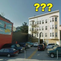
El Rio, 31 (El Rio, 151)
El Rio’s 31! Hooray! Being able to drink in the open air is the best.
Mission Mistaken asked for some recent history on El Rio, but my time machine only starts working a minimum of half a century back.
Mission and Valencia, 1858:
El Rio’s future site is the red rectangle.

The 1859 US Coast Survey map (surveyed in 1858, published in 1859) is digitally available thanks to the fine work of David Rumsey, including a Google Earth layer.
A field and a creek mark what will become El Rio. Valencia is not yet a road, and the path that will become Mission makes a hard right at stone wall bordering Precita Creek, the future Serpentine/Army/Cesar Chavez. A few building are clustered to the west of the future El Rio site, around the “Road to San Jose” (now cut off by the St. Luke’s doctors parking lot, Salvation Army and Guerrero Park).
I suspect that these buildings were the home of Jose C. Bernal, son of Juan Francisco Bernal, a soldier under Captain Juan Bautista de Anza, “Father of San Francisco”. (There is apparently a photo of the Bernal homestead floating around — if you know of it, please oh please let me know.)
After a successful stint as a government administrator in San Jose, Bernal was given a land grant in the 1830s that encompassed most of the land south of CC and east of the road to San Jose.
October 10th, 1839. Governor Alvarado to J.C. Bernal; one square league, being “Rincon de Salinas y Potrero Viejo.” It will be seen, by an examination of the archives, that Bernal applied for a grant of this land, and “La Visitacion,” on the second of November, 1834, two days before the order was issued by the Governor for organizing the pueblo of San Francisco. On the second of January, 1835, Governor Figueroa decreed on this as follows:
“As it appears, from the preceding reports, that the land asked for by José Cornelio Bernal is of the property of the pueblo of San Francisco de Assis, to which it serves as ejidos for the common cattle, the petition is not granted, as it cannot be given in ownership (en propiedad), but the party interested may keep his cattle there, the same as other citizens do.”
The Rincon de las Salinas land grant (encompassing La Lengua, Bernal and Excelsior/Crocker/Outer Mission) was secured by 1839. (He previously received a grant of farmland near Mission Dolores in 1834 and was given a third grant, El Potrero Viejo (Bayview and Hunter’s Point) in 1840.
But J.C. Bernal died in 1842, aged 46, and his widow Carmen Cibrian de Bernal and their son, José de Jesus Bernal, took over the land. However, like many rancheros, the family was not exactly focused on business and sold the land off bit by bit. Within 15 years the family moved off the Ricon de las Salinas holdings to live near Mission Dolores. By 1917, the Bernal descendants lost their last bit of land. The Bernal History Project points us to this 1929 obituary of the grandson, which gives more detail of their lifestyle. While not business savvy, they certainly seemed friendly:
The history of the passing of the Bernal grant was similar to that of nearly every one of the great Spanish and Mexican families who once held a huge portion of the best agricultural and grazing lands of Alta California. The dons and their descendants lived a feudal life, giving little care to business and leaving their vast herds of cattle and horses and great flocks of sheep largely to the supervision of the vaqueros and herdsmen. The homes of the owners were centers of hospitality. The Bernal family was no exception to the deep seated tradition of extending hospitality. The best road from the little Mission Dolores and the Presidio to the southern missions ran at the foot of the hill where the Bernal hacienda stood. The latch string was always out, and day or night weary travelers were welcomed by the Bernal overlord. It was this carefree life and lavish hospitality, coupled with the lack of good business instincts that led to the gradual breaking up of the grants. When the owners needed money, especially when the country began to attract Americans following the Mexican war, they borrowed. They never seemed to get ahead, and little by little the vast ranchos were whittled down through foreclosure of the mortgages.
SOLD FOR $1500: The first portion of the Bernal grant to pass to other hands was in 1859, when a foreclosure of a mortgage held by General William T. Sherman, resulted in the sale of a large tract from Butchertown to the San Bruno road by the Sheriff for $1500. General Sherman had loaned old Bernal $4298 in the early fifties. (ed: $4298 in 2009 dollars is about $100,000.) Later, the tract containing Hunters Point and South San Francisco was also sold for $1500. Other portions were sold from time to time, until in 1908 the last owner under the grant, the late Jose Cornelio Bernal, found himself in possession of only about twenty-five acres located west of Mission road in the little valley crossed by the Ocean House road, now Onondaga avenue, and used for vegetable gardens. This last tract was lost through foreclosure in 1917, and it marked the passing of the final bit of San Francisco real estate from the families of the original grantees.
(That vegetable garden was next to Balboa High School, and the Bernal Mission Dolores tract was on or near Mission High School.)
Thanks to Greg Pabst and his expansive article on the Bernal family, even longer than my typical diatribe but well worth the read.
UPDATE: Spanish land grants had to be approved by the US Federal government after California entered the Union, and here is a slice of the 1857 map showing the approved boundaries of the Bernal tract.

Bigger map of the tract on Calisphere. The Bernal residence was on the north side of what is now Duncan, at the SE corner of the St. Luke’s parking structure. Mashup of Google Earth, the 1859 Coast Survey map and the Bernal Survey.

I wish I had a seal like this for my house.

Mission and Valencia, 1886:
El Rio is an empty lot, next to some dude’s house, a glove factory and Misters Somers & Healy’s Hay, Grain, Wood and Coal Emporium.

In fact you can see many of the buildings in this wonderful (but sadly small) picture of the Mission from the SF Public Library’s collection, taken from the top of Bernal in 1888. You are looking to the NW and you just should be able to see the Mission/Valencia/Army triangle in the center, heart of La Lengua!
Somers and Healy’s two white buildings are just to the left of center, and the glove factory is to the right. El Rio would have been just to the left of the little white house beside Somers/Healy empire. (St. Luke’s is right behind that.)

(Anyone have a bigger version of this?)
2012 UPDATE:
Not the same photo, but roughly the same angle and much higher resolution! (Click to zoom, more detail at Bernalwood.)

Mission and Valencia, 1900:
In the 1900 Sanborn map of the area, you see progress – we have a harness and carriage trimming shop on the future site of El Rio! While I am not entirely certain what harness and carriage trimming involves, I suspect it would certainly be handy to amble on over to Mr. C.S. Healy’s and pick up some hay, or get your carriage painted at “Powell” and Mission. (Click to zoom btw.)

The 1908 directory tells us that JW McTigue owns that harness shop over at 3154 Mission on the future Rio site. 
And there seems to be a saloon across the street as well now – hooray, that’s handy! I bet Thomas Donlan’s bar at 3151 Mission is a fine establishment where you could get a nice steam beer from his wife Julia, listed in the 1915 SF phone book.
Mission and Valencia, 1914:
Jumping forward another 14 years, we find that (at least as of 1907) Healy’s is gone with Eagle Stables in its place. (I guess stables were like public parking lots?)
More saloons — one on the tip of Valencia and Mission — a drug store. Joe McTigue is still hard at work, and other friends and neighbors on Mission are listed thanks to the hard work of the Bernal History Project.

Joe (and his wife Mary) are still listed in the 1921 directory.

UPDATE: UC Berkeley Calisphere has a picture of the McTigue building in 1923, with carriages out front.

But within three years, the building will be torn down.
Mission and Valencia, 1925:
Let us venture into the future, somewhere between 1920 and 1950. Joe McTigue’s building is gone and we get our first glimpse of El Rio’s building (but no information on 3150 in the 1936 directory. No listing for Joe McTigue either, though there is a Mrs. A McTigue on Army near Capp, perhaps a relative.)
2012 UPDATE: A commenter in a Bernalwood post did a rundown on the McTigues!
Did some genealogical research on the McTigue family, the harness makers. Michael McTigue and Frances Acton were Irish immigrants born in 1830 and 1832 who started the business South of Market .
In 1872, they were living at 273 Minna, In 1880 on 8 1/2 Moss. with children Augusta, Fanny, Joseph, Richard, John and Jennie. By 1896 they were living at 19 Alvarado with their harness factory at 3156 Mission Street.
Joseph W. McTigue was born in 1866 and died in 1939. He married Mary Theresa Costello and they had a daughter, Marie. She married William Dabel and in the 1940 census they lived at 3182A Mission Street. They had a son William (1927-2006) and I”m trying to trace his descendants.
A corner that once specialized in horse-related industries made a wholesale jump into cars (and on the east side of Mission, apparently paint). Click to zoom.

Pretty much everything in the triangle south of Sears is car related, with the exception of a bowling alley (where Roccapolco is now) and a beauty parlor. Atlas Motors’ historical echo is doing the same thing as now, the AAMCO is the old Sears auto department, and Kragen was a car dealership – Mission Chevrolet! 
UPDATE: The crack Imaging Systems team at Telstar Logistics points us to these shots of Mission and Precita in 1926 and 1927 from the UC Berkeley archives. You can see Mission Chevrolet under construction in the first shot, and finished in the second.

North on Mission at Precita, 1926
North on Mission at Precita, 1927
The restaurant on the left will be called the Superior Grill in the 1930s, and will come to house Nap’s.
And here’s that great picture of the gas station on the corner of Valencia and Mission in 1944.

Some will remember the then-and-now shot I made a while back.
Finally, the Telstar Logistics Aviation Group presents us with this picture of the intersection in October 2009.

And such is 151 years of history from the corner of Valencia and Mission. Happy birthday, El Rio.
Flash Flood
Zoiks!

(Go pay Weather Underground $10 a year and you too get the cool longer radar loop.)
My street had manhole covers popping up exuding a mysterious brown material, along with RATS! Ugggggh, what a wonderful smell we have discovered. But this pales in comparison to escalator water drama.
And here we have San Francisco’s new elevated canal system:

Note – if the 101 canal is backed up, I recommend taking the 280 aqueduct:

And Mission Mission covers more flooding at 18th & Shotwell:
Shotwell and 18th was originally marsh on the edge of the Mission Lagoon, at the foot of the creek that ran down from Twin Peaks (via the 1859 coast survey map).

Old 18th St Creek and Mission Lagoon
Right of Way

At least he has a clear view of what could hit him.
Bernal Haze
Bernal bears the brunt of the sun’s expansion into a red giant.

Goodbye Plug1, Hello CALIBER
Plug1 is no more. Goodbye WHATIMSEEING.
But Troy Holden and CALIBER reign supreme!
Plug1 and WHAT IM SEEING go away on 11/23 via expiration
manual migration of ~10k images from Plug1 to Troy Holden: 6 months
daily upload of 43 images/day: 23 in the AM, 23 in the PM
~62k images backlogged in processing
CALIBER is the new WHAT IM SEEING.
So quick, go sub calibersf.com for WHATIMSEEING to your blogroll RIGHT NOW.
If Things Would Only Remain The Same – Troy Holden

To the left, the future! There is no turning back.
Will Code For Burrito

SF Planning Commission Meeting on St. Luke’s Future
The San Jose Guerrero Coalition alerts us to an important SF Planning Commission meeting tomorrow, Thursday, October 15th. The Commission will take public comment on CPMC’s Institutional Master Plan in City Hall room 400 at 4PM. This includes the plans for the St. Luke’s campus.
CPMC’s plan for St. Luke’s is not ideal. SJG’s summary:
This is the opportunity to tell the Planning Commission, before it meets to vote on CPMC’s plan, that the services proposed by CPMC at St. Luke’s do not meet the City’s needs. The Planning Commission will be listening on the 15th for whether we think CPMC is proposing the right services in the right neighborhoods at the right time, and not yet concerned about the size, height or urban form of the buildings those services are in.
We hope you will attend to tell the Planning Commission that the rebuilt hospital (that is, “inpatient care”) proposed for St. Luke’s has no future unless CPMC also builds the outpatient facilities that most people actually use most of the time. (“Outpatient and Urgent care” take place outside a hospital—primarily in doctor’s offices equipped with state-of-the-art medical equipment.)
The future of medicine is outpatient care, not in hospital beds:
Ten years ago, 90% of all cancer treatments were performed in hospitals, and 10% were performed in state-of-the-art medical offices on an outpatient basis. Today, the ratio is reversed. Increasingly, healthcare is about preventing disease and keeping us well and out of hospital beds in the first place.
St. Luke’s is doomed without modern outpatient care:
Currently, St. Luke’s has an average daily census of about 50 patients in its 229 licensed beds, and only about 7% of its patients have health insurance. The 11-storey hospital tower has heat but no air conditioning, and the average wait time for one of the 2 elevators is several minutes. The small existing medical offices are outmoded and full, and new doctors do not come to St. Luke’s.
CPMC is proposing state-of-the-art outpatient facilities for all CPMC campuses except St. Luke’s:
Just like every other neighborhood CPMC serves in San Francisco, we and our families need outpatient services in a modern health care facility in our neighborhood – at St. Luke’s – just like neighborhoods with higher per capita income. This will be especially true as San Francisco densifies in the neighborhoods South of Market Street. CPMC shows pretty pictures of a “future” outpatient building, but they make no assurance this will be built — and it therefore probably won’t. CPMC must be held to its promises.
We are designing for the next fifty years – let’s get it right:
With a lifetime of 50+ years, the facilities built at St. Luke’s will determine how both the medical facility and our neighborhoods function (or don’t) for generations. Let’s not merely rebuild what isn’t working now.
St. Luke’s is where the regional transportation is:
4 blocks from BART, St. Luke’s is the San Francisco hospital closest to regional transportation, particularly once San Francisco builds the Transbay Transit Center linking BART with Caltrain. Patients, Doctors, Nurses and students can readily access St. Luke’s from anywhere in the Bay Area – permitting a regional center of excellence.
If you live nearby but can’t attend, SJG suggests (and Burrito Justice agrees) that you should “email linda.avery@sfgov.org by Thursday morning, saying that rebuilding St. Luke’s doesn’t make any sense unless they also build outpatient and urgent care services – which the neighborhoods would actually use.”
Everybody Just Stay In Bed
It will just be better for everyone. Too much red.

USGS/SJ State Wind map – click for a cool animated version. (Thanks to spume for pointing this one out.)

SigAlert traffic:

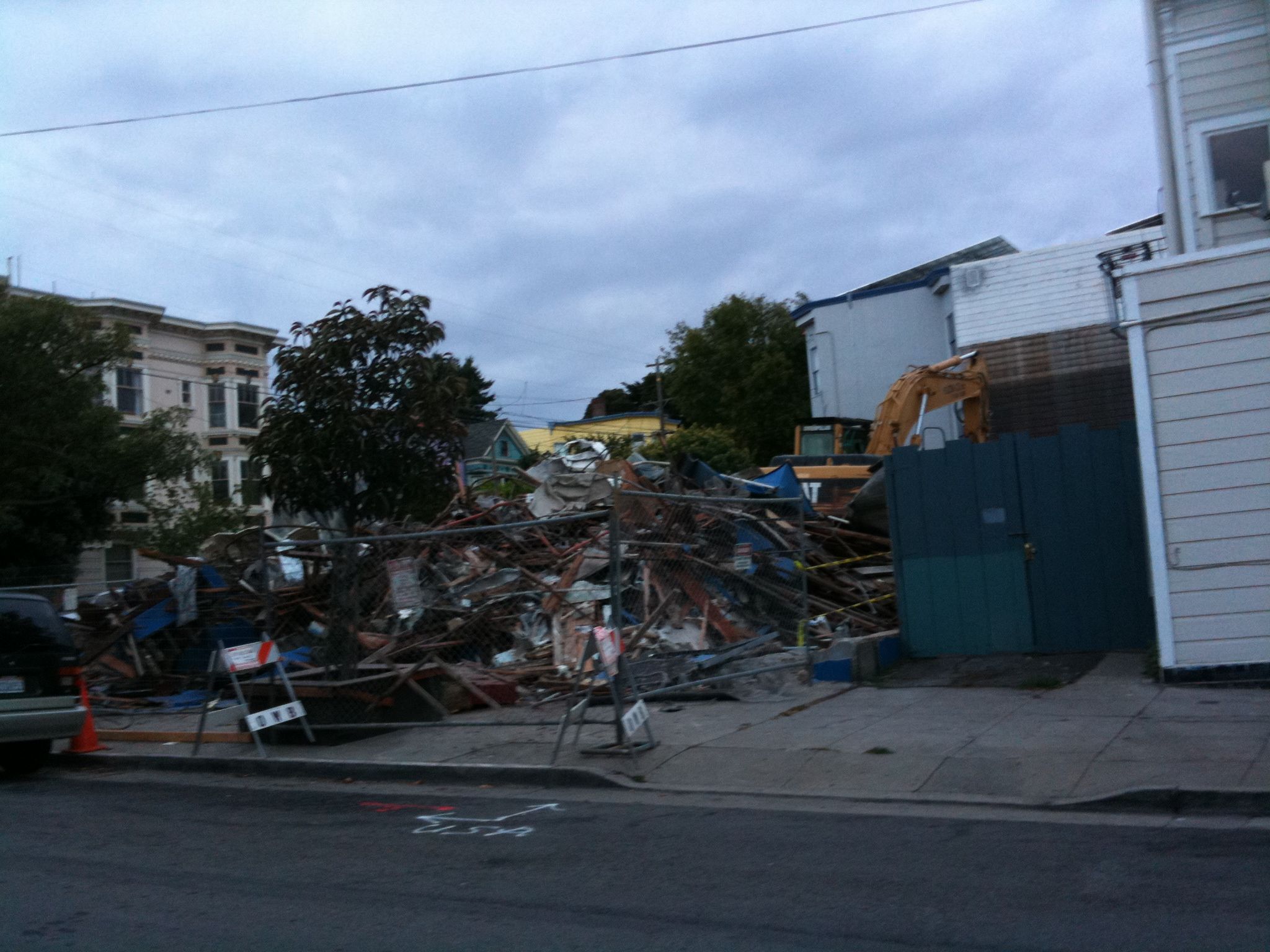
Church St Blues
Drama in Da Noe. Blue Church: You are on the way to destruction!
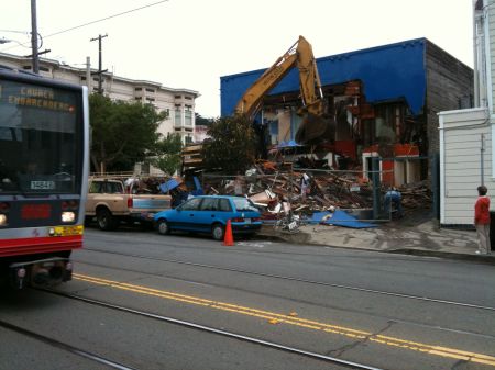

Water main turn on!

Hope they turned off the gas before they started.
The shots above were taken at 9 AM. And at 6PM:

The Noe Valley Voice has pictures from a quieter, more gentle time, as well as some background on the Blue Church.

“A developer got the green light this summer from San Francisco Superior Court to demolish the blue building at the corner of Church and 28th streets, now occupied by the Church of San Francisco. The firm plans to build a four-story condominium complex that will include retail space on the ground floor.”
UPDATE: Historically astute reader TS reminds us that the Blue Church was once a theater best know as The Rita.

It opened in 1916 and shut down in 1965.
The Rita was a little neighborhood theatre on the northwest corner of 28th and Church. It opened as the Searchlight on August 5, 1916, and changed names rapidly the next few years. It was variously known as the Empress (1918-1927), the Lux, the De Lux, the Isis, the Princess, the Church, and, finally the Rita (1945). That name seemed to stick, but in 1961, entrepreneur Ward Stoopes took it over and ran it for about four years as the Del Mar.
Never successful as a neighborhood theatre, its only means of survival seemed to be as an outlet for “ethnic” films, i.e. foreign films WITHOUT English sub-titles, usually German or Russian. Its last days as a film theatre were in May 1965, but it is still in operation as a neighborhood church, painted a bright, bright blue.
Interesting re the German angle — Lehr’s the German specialty shop is on Church and 28th, and in 2001 Incanto replaced the beloved German restaurant called Speckmann’s.
The SF Examiner’s Thomas Gladysz provides more details:
The Searchlight Theatre opened in 1916. Admission at the time was 10 cents for adults, and 5 cents for children. Its August 5th Grand Opening advertisement (reproduced in Tillmany’s book) boasted a “New Theatre, Good Pictures, Latest Music.” The ad went on to state “We are installing one of the latest models of the AMERICAN PHOTOPLAYER, with all the Orchestral effects at a cost of $5000. Be sure to see and hear it.” That was big money during the early silent film era.
Before the theater, there was a saloon on that corner as we can see in this 1914 Sanborn map. (Note the outhouses and henhouses.)

The number of theaters that were once in this city is rather amazing. But I’m getting the feeling that there’s an analogy between theaters then and newspapers today.