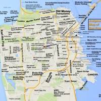
Camouflage
I am all for Gavin’s Pavement to Parks program, but this new one on Church St has gone entirely too far.

Kidding! Just a tree eating a truck. Or some sort of street food expirement gone horribly wrong.

Speaking of Pavement to Parks, Guerrero Beach got some new “sandpaint”. It’s quite nice, seems very durable, and much better than the taupe swath of mediocrity used on other paveparkments.


I spoke to the contractor — it’s some sort of epoxy that you then spread sand over. I think the other parks will be getting similar treatment.
And it turns out that Gavin even stopped by Guerrero Beach, er, Park. Points to Gavin for addressing our little nexus, but it’s called La Lengua.
Transport for Body


3300 Moon, Bernal Rising
From Sunday’s full moon:

I must be honest here — the above is poor man’s HDR (aka I really don’t know what the hell I’m doing when I’m taking photos at night as proven by about twenty shots with increasingly desperate exposure settings). I basically cut the corner of the picture of the short exposure on the left, and pasted it into the corner of the picture of the longer exposure on the right. Such is the short-lived reign of photorealism here at Burrito Justice. But it’s pretty much what my eyes saw.

This one was a 15 second exposure:

Sadly, I missed the opportunity for a dramatic moon-behind-tree shot by about 5 minutes.

Tsunami Tsalking
In addition to being a history nerd, I am also a geological-earthquake-tsunami dork.
Below is a consolidated view of multiple time plots for NOAA tide gauges along the California coast showing the (fortunately) small tsunami from Friday night’s 8.8 Chilean earthquake. Things start getting interesting a little after noon as the waves work their way up the coast. (Red is the observed water level and green is the difference from the predicted tides. Height in feet is on the right.)


Tsunamis travel across deep ocean about 500-600 mph, or about the speed of a airliner. Here’s a rather incredible plot of tsunami travel times from the NOAA’s West Coast Tsunami Watch Center.

Thanks to the curvature of our angry planet, waves from Chilean earthquake hit SF, Hawaii and Australia at the same time, about 15 hours after the earthquake. You can clearly see the ‘drag’ of the coastline and islands.
And here’s a tsunami “energy map” — red tendrils are bad. As you can see, it’s not evenly distributed.

Data for tide gauges is readily available online, and worldwide reported tsunami wave heights are published by the various tsunami watch agencies.
In addition to the coastal measurements, the US government has graciously peppered the oceans with “DART” buoys and sensors which can detect tsunamis as small as 1 cm by measuring changes in water pressure on the ocean floor.

Here we see the readout from a DART buoy about 500 miles off the coast of Peru from the day of the earthquake. The smooth blue curve on the left shows the normal ebb and flow of the tide.

I’m no tsunamologist, but in the center of the chart you can see the first tsunami wave hit around 10 GMT. And I’m no seismologist, but I think the big red spike just before 7 GMT is the earthquake itself.
Here’s the plot of the DART buoy off the coast of Hawaii showing the multiple tsunami waves passing through 14 hours later. You’re basically seeing the ocean ringing like a bell.

And here’s a Japanese tide gauge showing a (1.5m?) tsunami hitting Hokkaido, 24 hours after the earthquake.

This was small by tsunami standards, though wave height is greatly dependent on local conditions – note the difference between the LA and SF readings, the energy map, and the height of waves half a world away.
Somewhere I’ve seen a picture of Crescent Beach after the 1964 Alaskan earthquake — a playground jungle gym had the living crap beaten out of it. Here’s a picture of parking meters in Hilo after the 1960 9.5 Chilean earthquake.

Moral of the story is don’t assume it’s over after the first wave, and don’t run down onto the beach did if you see the water rush out to sea like those poor bastards in Thailand did.
There Goes The Sun
For all of you bummed out about the rainy grey, it’s much nicer 10,000 feet up.

And loyal reader Bernal Jim reminds us of the view of Mission/Noe/Twin Peaks/Sutro looks like at sunrise. (This apparently is an orange-tinged moment in time when the sun rises above the horizon, a mystery to me regardless of weather as I am not particularly conscious at that time of day).


Bernal Jim also provides us with an epic blue-sky-over-former-farmland to hold us over for better weather – click to zoom:


1968 Geary – Third – SFO Subway
More Eric Fischer retrofuture scanning – SFO rapid transit alternatives from 1968.

($300 mil is ~$1.8 billion in today’s dollars.)
I’d take the Geary section over the Central Subway in a second. Hopefully the 1968-Third would have been faster than today-T-Third’s 29 minutes from Embarcadero to 3rd/Carroll. BART is 32 minutes from Embarcadero to SFO, but it that just seems like a lifetime.
As an aside, here’s a fun smackdown comparing the T-Third to Dublin’s theoretically more expensive LUAS.
They were also considering a Third St monorail to SFO. Yours for under $100 million 1968 dollars! And don’t forget the 1956 Valencia-Mission Skytrain! Man, that that would have sucked.


I still say that we keep that Central Subway tunneling machine running to dig out a crosstown subway — take a left at Divis, then shoot through Castro and Noe to hook up with a 30th St BART and the Muni ROW coming down San Jose Ave. That would make it way easier for me to see shows at the Independent. Also, I’d be able to take the Geary subway to get to GAMH. That just leaves Slim’s, but a Van Ness line would take care of that nicely. Anyone have five billion handy?
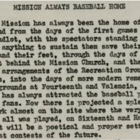
“The Mission Has Always Been The Home of Baseball”
“The Mission has always been the home of baseball.” So said Anita Day Hubbard in 1924.

Here we see some rather mind bending perspective:
- a 1920s patron of Recreation Park on 14th and Valencia (enjoying whiskey and chicken specials)…
- looking forward to a “splendid” new venue to be built in the 1930s (that we once knew as Seals Stadium)…
- that will be built a block from the site of the first baseball game to be played in California in the 1850s…
- and looking back on their previous baseball park from the 1870s, Recreation Grounds, at 25th & Folsom.
Arrgh, head hurts. Someone get me some chicken and whiskey.
Oh, and for those of you asking, nope – Recreation Park ≠ Recreation Grounds. Yes, I am going to tell you about ANOTHER epic baseball stadium in the Mission.
In 1924, Anita Day Hubbard wrote an epic series of articles in the SF Call Bulletin on the history of the city and the Mission which contain a staggering (wait, let me reformat that) — <blink><a href=”www.holycrap.com”>STAGGERING</a></blink> — amount of historical detail. But since we’re talking baseball let’s stick to that otherwise my head might explode.
The first baseball game in the city and the state was held at 16th and Harrison 151 years ago.

Drama in the Mission! Red Rovers refuse to finish the game! Eagles win!
So where was the game? Hard to say, but given the location of Mission Creek my best guess is the northwest corner of 16th (i.e. Center) and Harrison (as I doubt they played ON the bridge). While our favorite 1860s Calisphere view sadly does not capture anyone playing baseball (just slacker proto-hipsters), the field of baseball through time and space is captured quite nicely (click to zoom).

Here’s the 1859 US Coast Survey map, with red showing my wag at the location of the 1st game, and green the future diamond of Seats Stadium.

In the 1860s games were played behind the old Mission church, and by 1868, dedicated baseball grounds were built at Folsom and 25th.

Once again the Mission keeps Oakland down. But the Eagles were soon to feel the same fate.
The Cincinnati Red Stockings were the baseball team of the day. In September 1869, they took one of the first transcontinental train to battle their western foes. At Folsom and 25th, they proceeded to blow out our Eagles 35-4 on the 25th. The Eagles dusted off and… lost again. Even more badly, 58-4.

The Eagles, not to be deterred, played Cincinnati yet again. And were crushed yet again, 66-4. The Eagles local rivals, the Pacifics, got spanked 54-4, and the Atlantics’ attempt at coastal deception failed miserably, 76-5. The “San Francisco Pickled Nine” made a respectable offensive effort by only losing 46-14.
Thankfully for the San Francisco fans, I have evidence of a SALOON on site.

I suspect Mr Donnelly made a lot of money that week.
We’re lucky enough to have pictures of Recreation Grounds via the SFPL as well as the Online Archive of California. This OAC view is looking to the northwest from around 26th and Harrison, with Twin Peaks in the background. (Click to zoom.)

Crop on the players with my guesses on the positions.

Another view from around 25th and Harrison looing to the SW. (Bernal is in the left.) Click to zoom. SFPL dates this view as 1875, and I am pretty sure this and the above photo were taken on the same day.

Note the fans sitting on the edge of the outfield. We’re just about looking down the 3rd baseline and I believe the gaggle of players on the right are behind home plate.

Naturally, I’ve been trying to figure out where the baseball diamond was. Unfortunately the Sanborn maps don’t start up until after Recreation Grounds were built over, and none of the Library of Congress birds eye maps from the 1870 show anything.
But a very interesting point of reference is the row houses behind the grandstands that I’ve numbered 1-7.

All seven houses on the 2900 block of Folsom are still there today!

And the 1889 Sanborn map of Folsom at 25th lines up perfectly with Google Earth. (West is up.)

I hereby anoint this row of houses “The Folsom Ladies”!
Using this a point of reference along with my lettered trees, guesses as to the depth of the grandstands (red) and some burrito parallax, I figure that that first baseline could very well have run down Lucky St, with home plate about 6 houses south of 25th.

Looking south, from home plate down the first baseline (sorry, no blue tape).

And north from 1st back to home:

Granted I could be off by a dozen feet to the east or west, but a lot more fun to think of it in the alley than a yard (unless it were your yard, I suppose…) Any and all feedback/suggestion/criticism welcome.
And what was there before Recreation Grounds? We have to remember that in 1868 it was built smack in the middle of the old Pioneer Race Course owned by George Treat (yes, that Treat), just above the stone wall marking the northern border of Bernal’s rancho (yes, that Bernal).

One last note — these guys from 1875-77 could very well be the ones playing in the pictures of Recreation Grounds above.

IsoMissionMetric
Nice 1931 map of the Market Street Railway streetcar system via Eric Fischer. Click for city-wide map.

(Note the brand new Seals Baseball Stadium. Oh I would love me some good E-W light rail like that 22, with dedicated right of way… And something along CC while we’re at it.)
And Telstar Logistics brings us this 1947 sales brochure for new streetcars. Note this was right before SF tore out its system and replaced most of it with buses.

TL also brings us this Sirron Norris painting of SF transit.

Hmm, I am not sure if there is some sort of Muni reliability message here. Are these floating or flying?
(Note that Sirron Norris is now based in increasingly awesome La Lengua.)
Armand + Julie + Silvi at Secession Tonight
Secession (between 29th and 30th, across from Safeway) proves its reputation as La Lengua’s premier art gallery with its new show that opens this evening.
Silvi from the Poetry Store is a featured artist — not only will she will be crafting poems live, but on display is her collaboration with local talent Armand Emamdjomeh of Mission Loc@l and i live here: SF / CALIBER SF‘s Julie Michelle.
Armand’s shots focus (unsurprisingly) on the Mission — here are a few overlaid with Silvi’s work:


So go to Secession tonight (Fri Feb 12th), 6:30-9:30, 3361 Mission, across from Safeway. Shop locally and support Streetside Stories: Literacy for k-8 graders.
(And slacker hipster guys in your 20’s — I know you are on the verge of panic as to what to do about Sunday. I have been in your shoes, but do note that a poem makes for a cool Valentine’s day present.)
Yesterday’s Baseball Is Tomorrow’s Safeway
The world renowned Telstar Logistics Surveyor Unit recently highlighted the Google Earth historical image layer, specifically the San Francisco 1946 images. While many parts of town have stayed the same over the last 64 years, some of the changes are sobering.
A great loss was the Seals Stadium on 16th between Bryant and Potrero.

Facing the Bay, it was home to the Seals from 1931 until the Giants moved from NY in 1958. Seals Stadium hosted the Giants for two glorious seasons. This view from the northwest, looking southeast shows the rather magnificent curve of the entrance.

The joint geocoding prowess of Telstar Logistics and Burrito Justice was put to the test as we struggled to determine the location of the four bases. The Google Earth overlay proved to have quite a bit of wiggle — 100 feet E/W and 30 feet N/S, to be precise — and we turned to our old standby, Sanborn maps.

Using the all-powerful Google Earth overlay feature, we see how the ghosts of yesterday’s Seals haunt the Safeway and Office Depot of today:

(Click image for a wider view of the neighborhood, including the Rainier brewery, the Wonder Bread Bakery, Hostess Cake Kitchen and International Harvester showroom…)
Here we see a packed stadium San Francisco’s very first major league game against the LA Dodgers on April 16, 1958 where 22,000 fans watched the Giants ‘clobber’ the Dodgers. This view faces south, with 16th on the top and Bryant on the right.

Home plate is in deep within Office Depot, while first base is at the front of the store at a cashiers check-out station. Second base is in Safeway near the Starbucks, while third is between the tortillas and the frozen pizza. Telstar Logistics: turning yesterday into today with the magic of blue tape.
More pictures, because they are cool:
These hardy, flannel-clad folk are standing in line on 16th (behind the scoreboard) to buy tickets for the Giants’ opening day.


Here we see Willie Mays standing in front of the marquee in 1957, shortly after the Giants announced they were moving west.

Tragically, after just one and a half two seasons, the Giants moved to the monstrosity that is Candlestick, and Seals Stadium was doomed. Here is the groundskeeper tearing out home plate after the close of the Giants’ time at Seals Stadium.

“An era of 29 years was ended in 30 seconds today when Groundskeeper Harvey Spargo ripped up home plate at Seals Stadium. And he wasn’t happy… he’s been at the doomed ball park since 1930. Shorty Schurr propels the wheelbarrow on the sad circuit of basepaths trod by many baseball greats.”
And early in 1960, Seals Stadium was torn down.

Baseball would suffer for another 40 years until Pac Bell park came to be.
Deep within Office Depot, Telstar Logistics marks home plate and many other bases.

Here is a highly unorthodox attempt to align present photos with past baselines.

As previously mentioned on Mission Mission, the Seals were not the only team to play at 16th and Potrero. Notice from the Sanborn map that there are three dressing rooms. One was for the Seals, one for the visitors, and last was for the Mission Reds!

The Reds shared Seals Stadium until 1938 when they moved to Hollywood. The magic that is the SF public library gives us this 1943 shot of the Hollywood Stars playing the Seals in 1943. Note that the Mission Reds, er, Stars beat the Seals 6-4…

Baseball stadiums come and go. Where did the Seals and Reds play before 1931? In the Mission, of course — 14th and Valencia at Recreation Park. (The Reds (aka The Missions) moved up from LA in 1926. The San Francisco Missions played there for a single season in 1914.)

The magic that is Sanborn shows us the park and its environs in 1914.

Note the four armed “Mary’s Help” hospital behind the Levi Strauss building. (A multitude of saloons are included for TK’s benefit.)

Recreation Park was built in 1907 after the earthquake destroyed the Seals’ home on 8th and Harrison. Prior to the stadium, RP was occupied by “Chinese vegetable gardens”. Afterward it was the site of Valencia Gardens, originally built in 1943, torn down in 2004 and reopened in 2006.
MM Reader Jonathan notes the FoundSF article on Rec Park:
1906–After the Great Earthquake a new ball park, Recreation Park was built in the Mission on Valencia between 14th and 15th streets. A section of the bleachers, roped off with chicken wire became known as the “booze cage.” Admission price entitled the patron to a choice of either a sandwich or a shot of whiskey. Spectators who frequented the “cage” were said to be knowledgeable, loud and abusive. The team name was changed to the San Francisco Seals. The Seals featured a “reversed battery” of Nick Williams and Orval Overall–one would pitch, the other catch, then the roles would reverse for the following game. Overall eventually became a 20-game winner in the National League.
(I do believe someone needs to open a bar called the Booze Cage. I also want a chicken AND whiskey special.)
UPDATE: Reader Jon Voss is master of the epic LookBackMaps site, provider of geotagged historical imagery. He points us to more views of Recreation Park in 1923 from the Bancroft Library, (looking north on Valencia at 15th – click to zoom):

Anyway, the next time you ride your fixie down Valencia, think of Rec Park (and more importantly, the whiskey/chicken dilemma you faced a century ago).
Telstar Logistics has much more on locking down the actual base locations in Safeway and Office Depot over at Laughing Squid.