“Just Say No” Valley
Dear NIMBYs in Noe Valley: Seriously?
Your main argument against the trial of the plaza at Noe and 24th is that it will increase congestion? Is that the best you can come up with? Any self-respecting NIMBY should be able to do better.
Have you actually been to that intersection on a weekend in the past five years? I have seen cars fossilize while trying to turn left onto Noe from 24th, waiting for the pedestrian and stroller traffic to clear. Only when some hipster mom takes pity on them do they get a chance, but by that time the driver has had their brain pulled through their nose, been wrapped in muslin and are in a museum.
Your dreaded fear that cars will overrun your side streets is already happening — no one in their right minds drives up and down 24th or Noe, they’re all hitting Sanchez and Jersey.
Oh NIBMY’s, your other arguments are lame as well. NoeValleySF commenter Yizzing has a rather awesome summary of the hysterical anti-plaza arguments:
- plazas at the bottom of a hill bring death and carnage due to runaway vehicles
- this location is too “windy” for people to congregate
- plazas are for hipsters
- no businesses want a bunch of extra patrons hanging around
- (the overly bizarre) Noe Valley is “already pretty nice” and (conversely) full of gangs and potholes
- Noe St is a “major thoroughfare” that must be preserved (if not widened and “expressified”)
- emergency vehicles will never be able to figure this out change
- 24th Street will be massively overburdened with traffic (from where exactly?)
- I will be inconvenienced by driving one extra block…
If anything, the plaza will improve the flow of traffic on 24th. And if there’s any congestion, it’s on the sidewalks — I hereby demand the plaza to release the pent up demand for outside sitting. I can barely get past Martha’s as it is.

IMPORTANT AND SERIOUS POINT: If you want this trial plaza to go forth:
a) show up at the hearing this Thursday the 8th at 665 Elizabeth St.
b) email Andres Power at SF City Hall who runs the Pavement to Parks program to show your support for the trial.
We can blog and bitch all we want but these meetings are where the decisions get made. Bevin is already showing signs of wavering due to the very loud anti-plaza folks, but I do believe they are in the substantial minority. Prove it to them by showing up at the meeting on Thursday.

(And Bevin, I am disappointed in you. If you fold like a cheap deck of cards you’re never going to get elected mayor. Show some spine, it’s a trial plaza.)
But Burrito Justice being what it is, I shall pull the historical card to neutralize the hysterical arguments. Behold!

Yes indeed, in 1886 there used to be a pond on Noe St between 24th and Jersey.
If you don’t give us our trial plaza, we are going to summon the creepy water monster that once inhabited it to haunt you for the rest of your days, emitting foul aromas and lowering property values. (And you’d better hope he’s not related to Gulchie, the sinkhole monster that lives under Valencia and 18th.)
NIMBYs, let the trial plaza run its course and we’ll make a decision after we see how it works out. Or is fear your only argument?
UPDATE:
For those of you claiming that Noe St was a “major cross street” both today and in the past — sorry, but there was nothing there before the 1880s. The only roads in the area were to Rancho de San Miguel up where Douglass & Elizabeth are now (yellow fill). One path was along 24th and Elizabeth (red), and others held constant elevation along the north side of Noe Hill (blue/green). The orange line is where Noe St is today. Cows don’t like to climb 150 foot hills in five blocks.

US Coast Survey Map, 1859 (surveyed in 1857) – link to David Rumsey, click image to zoom. Orange line is Noe St today.

1869 Coast Survey Map, link to David Rumsey.com, click image to zoom. Orange line is Noe St today.

Even today, that’s one hell of a climb – elevation estimates from Google Earth:
176 feet at Noe & 24th
345 feet at Noe & Hill (vs 360 feet at the top!)
94 feet at Noe and 18th
That’s a 170 feet up Noe from the south, and 250 feet from the north!
Bacon Street Closed Ahead
Good news: there’s a Bacon Street in town.
Bad news: it’s closed ahead. Oh dear.

I now have bizarre mashup of Peter Gabriel’s Mercy Street and Hammertime going through my head.
“Dreeeeaming of Baaaaa-con Streeeet, sweaaaaar they moved that siiiign… STOP! It’s BaconTime!”
While I am very happy that there is such a street, I do not see how the road closure would fit into the bacon flowchart.

Just be sure to avoid bacon FAIL.
Damn The Bay
I’ve posted too many times on the myriad plans for bridging and tunnelling San Francisco Bay. But Eric Fischer has scanned much darker plans for covering over the Bay.

The red is proposed fill. “Hey, let’s dam off the South Bay with a 2000 foot wide berm between SF and Oakland.”
This plan was pushed by John Reber in 1945. He proposed creating two massive freshwater lakes in addition to the new real estate.
There’s no denying that lots of San Francisco is built on “made land” — the Marina, North Beach, SOMA, the Mission, Dogpatch, Treasure Island. But these mid-century plans take it to a whole new level.
More detail is at the UC Berkeley’s Bridging The Bay site.

I do love this Christmas card the Reber’s sent out. What jaunty signs! That completely justifies the wanton environmental destruction.

(via UC Berkeley)
The US Army Corp of Engineers took the plan seriously enough to build a 1.5 acre hydraulic model of the Bay to test it.

(via army.arch)
An understatement from the Reber plan Wikipedia page: “The barriers, which were the plan’s essential element, failed to survive this critical study.” Rather shocking, given Reber’s background as “an actor, theatrical producer, and schoolteacher”.
The Bay Model in Saulsalito is full of actual water. Before you rush over to see it as I just about did, realize they just got some Obamadollars and are closed until Memorial Day weekend for upgrades. Which is good, outside my desire for immediate gratification to see something made to rebut a crackpot plan.
Now I know what you’re thinking — “Why have barriers so far back in the Bay? Clearly the answer is to build a barrier around Treasure Island itself!” Fret not, as Mr. Savage’s plan had your back:

(via Eric Fischer)
Glad they are thinking of the fishes too.
Taking it even further, why not connect Treasure Island with Angel Island? Oh, but Mr. Dennison’s way ahead of you.

(via Eric Fischer)
Andrew C. Swanson had yet another plan to fill the Bay — he wanted to level San Bruno Mountain…
“…this barrier which otherwise would continue to plague San Francisco and the Peninsula FOREVER. Also, eliminating this barrier would provide more land for homes, cemeteries, and rapid transit facilities; and it would remove the ever-present hazard of plane crashes against this mountain.”

(via UC Berkeley)
(San Bruno Mountain *is* kind of a pain in the ass, especially since the San Bruno Curve will significantly slow down our glorious high speed rail.)
All these plans kind of makes a second BART tube and a 30th St Station seem reasonable, no?
If Sutro Had A Moustache
Uptown Almanac brings us some Awesome:

But what this poster needs is some Zapata:

With appropriate accessories, of course.

And yes, ‘stachetastic is a most excellent iPhone app, especially since you can make just about anyone look revolutionary:

3C Moon

Click through for a wider view. One in a series.
“That’s no moon, it’s… wait, yes it is.”
“That’s no moon, it’s… wait, yes it is.”

Via our favorite astronaut, Astro_Soichi.
(Meanwhile, the moon is thinking, “that’s no space station.”)
And since we’re on the theme:

(via somethingawful)
And of course a Star Wars occupied SF:

Name Space
Remember Weather Sealed’s crayola color history?

His data-slicing color ebullience strikes once more, but this time with historical names of humans, based on Social Security Administration data.


The SSA data and the dynamic charts were remarkable in their own right. But WS shows sheer and utter brilliance in how he sorted it:
From the SSA data, we extracted the historically most-often-bestowed first names, one-hundred-and-fifteen per gender, and then charted their relative ratios by year, arranged with the older towards top and bottom and newer in the middle.
Head immediately to Weather Sealed to escape the bounds of my narrow blog to see the data in its full resolution glory.
La Lenguans of the World, Unite!
La Lengua, now is your time! The Chron’s Carl Nolte has properly identified us as a distinct neighborhood, though he sadly called it “San Jose Guerrero”, something that doesn’t exactly roll of the, um, well, you know.

And so, my fellow La Lenguans: ask not what your neighborhood can do for you — ask what you can do for your neighborhood. Brace yourselves and jump into the knife fight that is the maelstromic, shark infested SFGate comments section and properly ID your hood. We have a long and glorious history of which you should be proud.

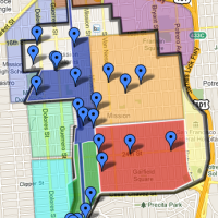
I’ve updated map in the La Lengua tab. Also, I recently expanded our northern border to 24th since the Mission didn’t seem to be using it (semi-permeable hipster membrane, etc). Considering a further thrust to 23rd.


Crescent Zoom
Hello giant fig tree.

Wait, what’s in that gap between the branches?

Zoom in a little more…

Good day, moon.

Gratuitous shot of wispy clouds that were in front of the moon but passed by before I could get my camera. Damned wind.

Moon, molding. Molding, moon.

Cartography Meets Gastronomy
Cherry Chaicharn of August Table currently resides in Hong Kong. Luckily for us, this former SF city planner has made a rather lovely series of plates on maps. Cartography meets gastronomy — what more could you possibly ask for?

A plate featuring La Lengua, that’s what:

(Note: Red border only visible once thin, transparent lines of food or sauce applied to plate.)
Plates available from SFMOMA and Perch in Glen Park.
(Via the underrated, but not to be underestimated Eye on Blogs.)