Sutro Controls Both the Vertical and the Horizontal
From chert to shining sky (finally):

And a more traditional panorama, with requisite puffy clouds — 180º, Sutro to Candlestick, 8600 pixels wide, click image to zoom (6 images merged with Autostitch on the iPhone)

If you look closely you can kind of see the snow on Mt. Tam and Mt. Diablo (along with a number of ghosts who inhabit Twin Peaks).
Also, a quick and dirty Occipital panorama (full 360, but lower resolution and crappy vertical stitching).

And SutrODC:


ODC is awesome by the way. They’ve got some really great space in their old and new buildings.
And here is what Sutro sees of us, the denizens of Mission / La Lengua / Bernalwood / Noe:

Click image to zoom, or feast your eyes upon the green jewel of southeast San Francisco, Bernal Heights:

History 1, NIMBY 0
A grand debate is brewing over at Bernalwood over a classic Coca-Cola mural and NIMBYs who shall remain nameless. The NIMBY has complained to the city that the (to me) obviously classic mural is an “unauthorized billboard”.
While we think the whole thing is ridiculous won’t pass judgement, we will present historical documentary evidence on the possible provenance of the mural at 601 Tompkins.
Per Bernalwood, “If some evidence can be produced that the sign was in place prior to 1965 (when the City’s operative sign ordinances went into effect), the matter may be resolved pleasantly.”
First, Sanborn Maps. The 1950 Sanborn map series clearly shows 601 Tompkins marked with an S for “store”, not a D (dwelling) or F (flat/apartment).

Next, SF City directories. The 1963 Polk Directory for San Francisco shows a Tipton’s Grocey at 601 Thomkins (owned by a Inez Tipton).

The first reference I can find to Tipton’s is the 1948 directory with E B and Inez Tipton. (He and Inez show up in the 1945/6 directory at 307 Barlett @ 24th.

EB seems to be listed as both Emim and Edward. If so, he was listed as a caterer in the 1943 directory at 828 Church St @ 20th (pre-Inez). The first reference I can find of E.B. is the 1934 directory where he’s listed as painter at 1121 Guerrero @23rd. In 1936 he was at 975 Capp @25th. (The Mission is strong in these two.)
The Tiptons lived next to their shop at 617 Tompkins and then moved to 629 at the corner of Prentice in the mid 1950s. Inez is shown with the store and Emin is listed as a contractor.
The last reference to Emin is 1959 — Inez is listed as a widow in the 1961 directory.

Tipton’s Grocery is last listed as a distinct address in the 1967 directory. While it’s still included with Inez’s personal listing for a few more years, I think that’s more a database update than anything — in 1972 she’s listed as retired. (She was still in the 1982 directory, the last I have access to.)

(My, late 1960s, what horrible fonts you have.)
As for the date of the mural — I kind of doubt Inez laid out cash for a new mural two years before she retired. The style certainly seems 1950s to me, which is supported by their ownership of the store.
Also, since Emin was a painter / contractor, he very well could have painted the sign himself, but that would have been before 1960.
Feel free to comment.
Sanborn San Francisco Map Lettering
Bibliodyssey recently highlighted the rather amazingly ornate title pages of our favorite historical map source, Sanborn.


San Francisco was sadly lacking, so as a public service I present you our very own Sanborn title pages. Click to enlarge:
1887:

($100 in 1887 is about $3000 today.)
1899:

LookBackMaps made a rather epic skateboard using this design:

(The top and bottom of the crest on the bow and stern of the deck was a touch of genius.)
The 1913 edition is pretty awesome:

California maps can be viewed via SFPL.org if you have a library card & PIN. Also, the SF 1899-1900 set is available on sfgeneology.com.
The originals are in color — the University of Utah has done an outstanding job on their collection. (Some of the trials and tribulations of this project are documented here.)
In all reality, the entire set needs to be rescanned — the ProQuest scanning is pretty dodgy quality, especially for the oldest maps. (I believe they used from the microfilm versions.)
Hey, can someone just buy Sanborn for me so I can tile all these together into a map layer? (Hint hint, Google).
Farallons via SF (and vice versa)
Wednesday was beautifully clear — I was stunned at how clearly I was able to see the Farallons, 27 miles away.
From Daly City, above Pacifica via iPhone + binoculars (but the field of view is pretty much what you’d see by naked eye)

The peak is 350 feet — for some perspective, that’s about half way between Bernal and Potrero.

(Strange to think that during the Ice Age it was just a big hill, and the coast was even further out. Makes you wonder what archaeological treasures are underwater. Also, the Bay was just a valley, and SF would have been way the hell inland, essentially the Orinda of the Pleistocene.
Did you know that when the BART tunnels were being built in 1972, they found 5000 year old human remains over 50 feet below Civic Center? They were once at ocean level but the area filled with sediment as sea levels rose after the ice age.)
I’ve always wanted to see SF from the Farallons. @theoverheadwire was nice enough to ask his cousin’s wife who was doing scientific research on the island take some photos. I jammed these together into a panorama (big surprise, I know).

4000 pixels wide, click to zoom. Labelled version (best to my knowledge, let me know if you think otherwise):

The GGB seems ridiculously far from downtown, no? Guess this really emphasizes what 7×7 really means.
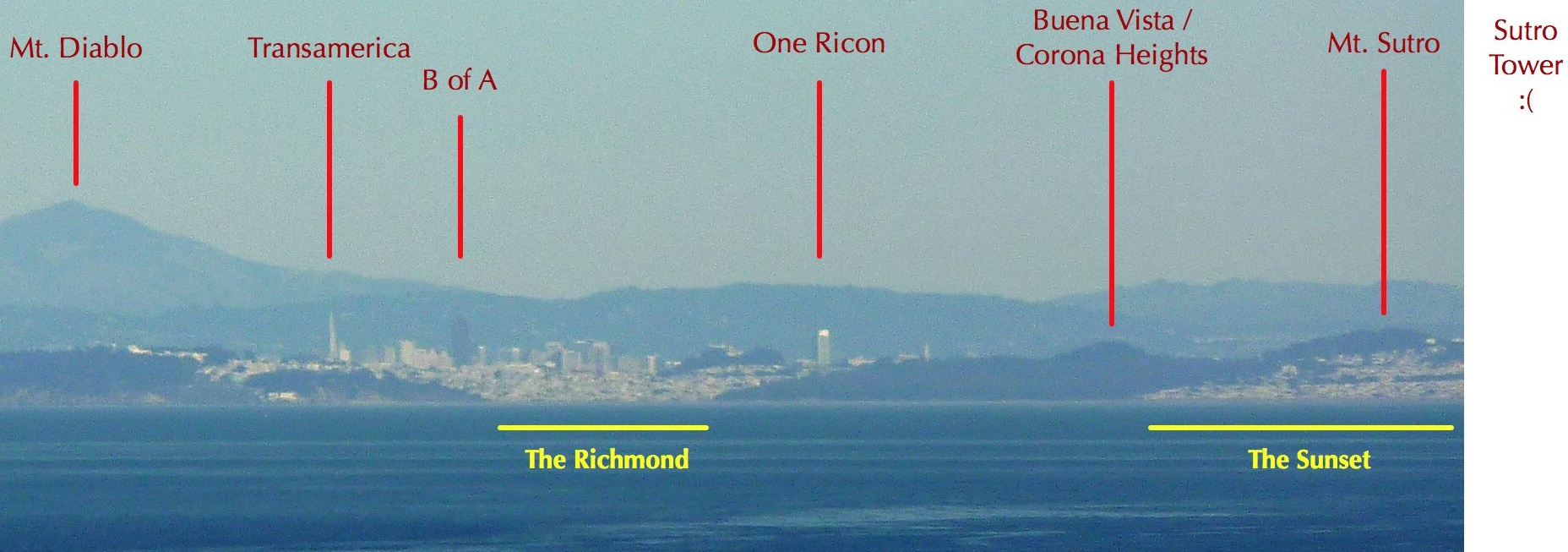
Crop of on downtown / Richmond / Sunset:

Tragically, Sutro Tower is just out of view. Guess I’ll have to rent a boat (full of beer, of course) and take some super zoom shots in the afternoon / sunset.
IMAGE UPDATE: Geoweb pointed out what I had originally labelled as Buena Vista / Corona Heights is actually Strawberry Hill in Golden Gate Park (400 feet, who knew? but it’s about half the height of the buildings so it makes sense) and what I had as Mt. Sutro is Buena Vista (575 feet). And troymcluresf noted that the bit I had as Sea Cliff was actually Lincoln & Pershing in the Presidio. I have no idea how long Baker Beach actually goes — there’s a Marshall Beach?
In a further effort to make your head implode, here’s what SF looks like from the other direction, via Mt. Diablo, 31 miles away:

Alas the Farallons aren’t visible in this shot. But here’s Sutro:


Bernal 360 Sunset
I do love me some Bernal – iPhone panorama at sunset.


Better yet, take a look at it in the coolio Occipital spinny panorama viewer (no plugins, don’t worry, iPhone friendly).

So up on the Boulevard I saw this Dark Jerusalem cricket / potato bug– it was no kidding 3-4 inches long. Disgustingly fascinating. (Deep fried, this could be a serious appetizer.)

I could look at this all day.

Taquita Justice likes chert too.


ゴジラ vs ウルトラマン vs ストロ
My money is on Sutro.

(image via sfkid and bhautik joshi)
Though it almost looks like Sutro is *promoting* the battle. In that case I’d go for ゴジラ since ウルトラマン can be an annoying little fuck.
Hmm, on second thought, Ultraman’s colors are very similar to Sutro’s, so I may have just committed sacrilege in the above statement.

Lincoln is the Bay Bridge as Magnum is to Sutro?
Big Day in New and Old Media
The kind and generous editors at Curbed SF asked if I would write about La Lengua in their People’s Guide. Humbled, I wrote forth, and Behold! Everthing you wanted to know about La Lengua (but were afraid to ask). Viva La Lengua Libre!

Also, some website called “SFGate” wrote an article titled “Who names your SF ‘hood“. Well, we all know the answer to that — not realtors. But they do give a nice shout out to my Islands of SF map (though fail to acknowledge the supremacy of La Lengua. Oh, old media, when will you learn…)

Important Space Burrito News
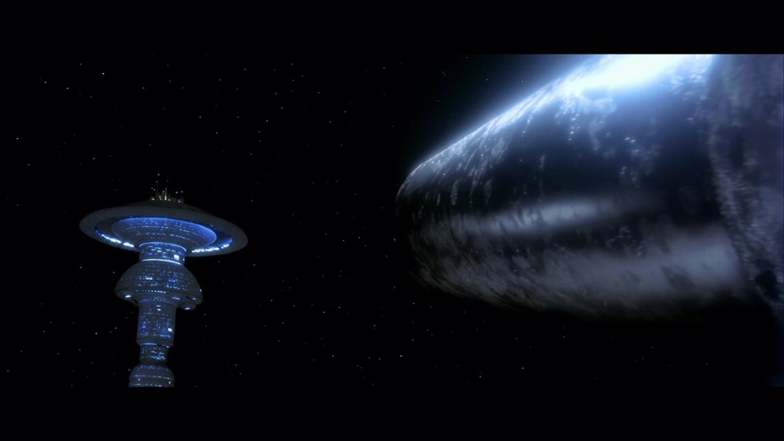
I re-watched Star Trek IV this weekend. For all of you born after 1986 a) I hate you and b) go watch it — it’s set in San Francisco and is legitimately amusing.
Anyway, a few Important Observations:
Does Sutro Tower still exist in the 23rd century? Inconclusive. There are precious few shots of the future skyline. Future Starfleet headquarters is supposed to be in Sausalito, but this shot is clearly from the Marin Headlands right above the bridge.

(How this ever will have gotten zoned I do not know. (Note also that this is the same angle as that ad with the chick sleeping in a bed. Outside. During the day.))
Anyway, this damn Starfleet Admiral insists on standing in front of Sutro’s most likely location, but there *is* some sort of tower above his left shoulder (well, really *his* right shoulder, but anyway).

Long Live Sutro Tower! I look forward to drinking on your observation deck one day.
TRAGIC UPDATE: reader Skitten reports: “So I went and checked, for that matte painting is still hanging on the wall at ILM, and can conclusively say that there is no Sutro Tower in the 23rd century.”
So the basic premise of our finely crafted movie is a big spaceship comes to earth to check up on our humpback whales. We have of course hunted them to extinction, and the interstellar craft’s songs causes it to rain and shut down the planetary power grid (insert 23rd century PG&E joke here).
Kirk & Co. go back in time to try to grab a couple of whales. I won’t bore you by repeating the tons of movie tidbits available online, but I discovered two extremely important points for our readership.
1) The hospital they take Chekov to is “Mercy Hospital” in “The Mission District”. (I bet you that’s right next to that “Mission District” cowboy bar in 48 Hours.)
2) The whale singing ship that attacks Earth is in fact A GIANT BURRITO:
I can now see the plot for Star Trek XII: a giant burrito comes to 23rd century earth to check if pollo asado still exists. They broadcast loud mariachi music planet-wide, listening for a response of songs with horns and “mi corazon” in the lyrics. Of course, in a Demolition Man plot twist, Chipotle is the only survivor of the restaurants wars. The ship immediately attempts destroys the earth, raining down petagallons of pico de gallo. Kirk and Co. travel back in time to 21st century San Francisco to steal an El Tonayense and a Buena Vista taco truck (so they can mate) along with a tanker full of Negra Modelo.
Best Twitter response goes to @boxcatninja: “now I’m hungry for a burrito wrapped in transparent aluminum.”
Bernal Time Travel
Bernalwood has been usurping our traditional historical analysis role. A classic example was their recent “then and now”post on Hampshire Street homes. (1982/2010).
So we lay down the law and break out our 90s era animated GIFness:

(click to zoom)
Eerie that none of the cars are parked in the same spot, no?
Cole Valley Alley Solves Cistern Mystery
Cole Valley Alley is a new and burgeoning blog in the shadow of Sutro. (And yes, Cole Valley, you do indeed exist — please see the center of the map.)
CVA asks the perennial question, “what’s up with the circular brick patterns in the middle of San Francisco streets?” Here’s the geometry of mystery at Frederick & Shrader:

and 13th & Folsom:

“My curiosity was piqued. What do they mean? Why are they there? Are they the remnants of an ancient civilization, a decorative flare from a bygone era of well funded city government, or simply the remains of an old cobblestone street?”
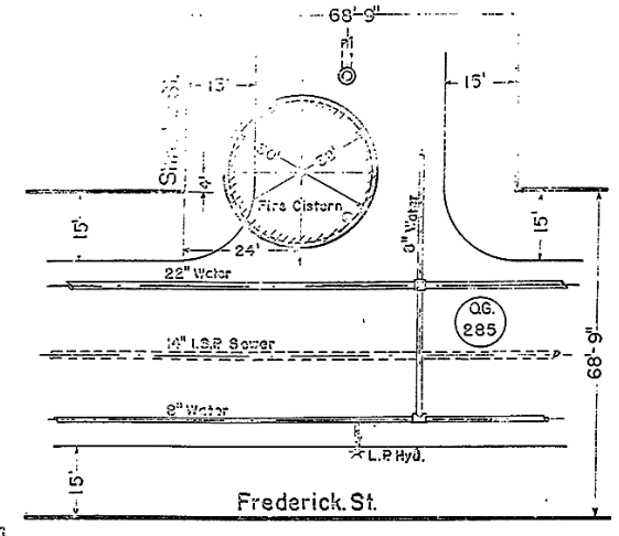
CVA quickly passed the SF history/infrastructure rite of passage and discovered they are SFFD water cisterns. But what was impressive was the route they took to get this information. They emailed the SFDPW and got a great response, including the original 1909 plans for the 75,000 gallon cistern on Frederick & Shrader:

(bonus: awesome fonts!)
The also received details on how the brick circle is to be laid in a bed of supporting concrete:

(For about 10 minutes I puzzled over this diagram, misreading inches for feet and interpreting it as a cross section of the entire structure. I couldn’t for the life of me figure out how the damn manhole was floating over the cistern. But I digress.)
The bricking rules are very specific (and oddly comforting):

Glad to see the partial circles are intentional.
These upgraded and reinforced cisterns were a big part of the redesign of the fire response system after 1906 — the cisterns were to be a source of water of last resort if the water mains were destroyed. They had been around since the 1850s — in fact you can see them in the 1853 and 1859 Coast Survey Maps:
1853, around Dupont & Washington:

And 1859, around Sansome & Pine.

Anyway, a warm welcome to Cole Valley Alley and their infrastructuriosity!


