San Francisco Archipelago
March 20th, 2072 (AP), Northern California Association of City States:
With the surprising acceleration of sea level rise due to the melting of both the Greenland and Antarctic ice sheets over the past decade, the San Francisco canal system was officially abandoned this week. Additional ferry service has been announced between the new major islands of the San Franciscan Archipelago while the boring machines make progress under the Van Ness Passage and Richmond Pass for new transit tunnels.

UPDATE: the NCCS (Northern California Coastal Survey) has made posters available.
Street Map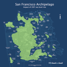 Order poster or wrapped canvas on Zazzle |
Topo map Order poster on Zazzle |
Street detail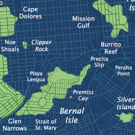 |
Topo detail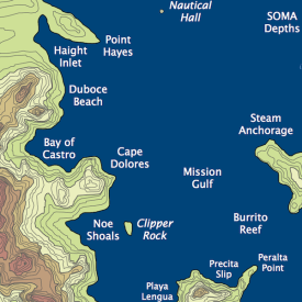 |
Unlike most coastal areas of the former United States, the population of the archipelago has dramatically increased despite the 200 foot rise in sea level over the past 60 years. Pundits debate whether this is due to the increasingly tropical temperatures or the creative and cultural explosion due to density. Regardless, the 4 million people now living on the SFA are demanding expansion of the San Andreas airport — studies are underway to build three more runways on the former 280 right of way.
However, the new class of supersonic Clippers will be in service by 2074 and Pan Am claims they can provide direct service to both Haight Inlet and Excelsior Lagoon, much to the relief of the Juniper Serra Conglomeration. (The JSC clearly prefers repurposing the old road to construct a rail gun space launch system with the help of Stanford Alto.)
The cruise ship berths along Divisidero Harbor continue to be upgraded, while negotiations are underway with Port Orinda and Caldecott Harbor to handle the cargo from the outdated facilities at Geary Sound. With the addition of the 6th high speed rail tube to the mainland, the original tunnels (completed in 2025) will be dedicated to cargo.
Development of high rises along the Sunset Coast and Cape Dolores has not been without controversy. The SHSFPA (Submerged Historic San Francisco Preservation Association) has once again protested and filed an environment historic review. “Old San Francisco is still alive in our hearts and minds, even if only the tops of the buildings can be seen! Look at the Flickr archive! ¡Viva Valencia!” While the SHSFPA frustrate many, all agree that their work floating Victorians and Italinate era homes and converting them houseboats has been a grand success, and has fueled a tourist boom along the Noe, Bernal and Dolores docks. The historical reenactments of life in the Mission District of the early 21st century have proven particularly popular.
While the submerged ruins of the Sunset and the Mission have always been popular diving attractions, many have already forgotten the locations of long-flooded streets and avenues. The SHSFPA recently published this overlay map showing early 21st century streets (double-blink to zoom, triple-blink for 3D):

While other islands have embraced both bridges and tunnels — the 150 year old bridges across Glen Narrows are scheduled for destruction once the new suspension bridge to Bernal Isle is complete — Potrero Island continues to be a holdout. Residents have yet again rejected the bond measure for a floating pontoon bridge crossing Beronio Reef and Market Shoals. Ask any Potreran and you will get the same response: “We were the first island, and we will be the last island. The cable gondola to Sutro Tower and Bernal is too much as it is.” Unfortunately, with sea levels increasing, they will very likely be flooded out by the turn of the century as this animation shows (GIF2023 support required, gesture for higher resolution holograph):

Is the future of the San Franciscan Archipelago doomed? Some environmental experts from the NOAA in the Washington DC SeaDome think so. “With sea levels continuing to rise at over three feet per year, the continued investment in the Archipelago is foolish. The failure of the Los Angeles seawall in 2049 is proof of this. And just look at the projection at 300 feet. Potrero’s all but gone and Bernal Isle is cut in half.”

As usual, San Franciscans are undeterred. “We won’t let those waterlogged Morlocks who pretend the United States still exists try to tell us what works. Even if we have to build a dozen more mile high Sutro Towers, we will stay here. We’ll anchor a floating city to the serpentine and chert if we have to.”
SF topological map via the most excellent Urban Life Signs. It turns out they were also working on a 25 foot sea level rise map, something we could very well see in our lifetimes.
Potential Sea Level Rise from melting ice caps:
- Greenland: 6.6 meters (21 feet)
- West Antarctic: 8.1 meters (26 feet)
- East Antarctic: 65 meters (213 feet)
120,000 years ago, SF Bay was 20 feet higher than today.
125,000 years ago, San Francisco was actually an island thanks to the Colma Strait. More here.
Bubble Radar
Rainy days are much nicer when you convert them to bubbles.

Individual frames converting using the lovely Percolator app and strung together using ImageMagick.
The original source radar loop:

The Moon is Up
The moon is up
Do not fear
It’s time to drink
Another beer
Multi-camera moonrise by Jobius Technologies:
And this moon / Jupiter / Venus timelapse is pretty cool too:
This is a good time to update you on upcoming planetary and lunar advisories. The crescent Moon will pass between the two planetary wanders from March 24th to March 26th, which should make for dramatic sunset timelapse opportunities.
The 26th will be another opportunity to spot Venus during the day when the Moon passes within 2 degrees of our thermally disadvantage neighbor. (For perspective, the moon is half a degree wide so that’s less than two fingers held at arm’s length.)
Here’s a shot I took on February 26th at lunchtime with my iPhone (through clouds no less) when they were even farther apart. Venus was surprisingly visible to the naked eye, but only if you were looking directly at it.

Burrito Rail Gun
This weekend saw an act of provocation when the Bernalwood Air Force clearly and intentionally violated La Lenguan airspace. While this was painted by Bernalwood apologists as a mere observation flight, the LaLeReAiDeCo (La Lenguan Revolutionary Air Defense Council) has taken measures to prevent such a transgression in the future.
First, taking a page from the cold war, we have erected a “ring of salsa” to prevent future transgressions.

Second, while Bernalwood Forces may have identified the location of our animated GIF production facility, we have since distributed it throughout multiple nodes for full GIF89a redundancy as you can see in the above schematic.
Third, we would also like to make the BAF (and other neighborhood aviation concerns) aware of our latest technogastronomical advancement, the weaponized burrito. With a warhead of extremely potent al pastor and avocado, it has currently has a range of several rachos.
Lastly, the La Lengua portion of Valencia St has been converted into a rail gun to facilitate kinetic burrito delivery. Recent PG&E “outages” in San Francisco are in fact test firings of the LaLeReKiBuLa (La Lengua Revolutionary Kinetic Burrito Launcher), and the “sewer construction” along Cesar Chavez will act as the cooling system once the system is fully operational.

(original railgun image credit: Wikipedia)
During peacetime when extra power budget is available, we will be able to leverage our infrastructure for humanitarian concerns, including emergency burrito deployment to regions infested with Chipotles. Our burrito rail gun should also break the transcontinental stranglehold of the nefarious Burrito Tunnel monopolists.
And don’t forget, Bernalwood — Sutro is watching you, and your Sutrito too. We have coordinated with Darth Sutro to emit high frequency radio waves to help steer burritos under high g-forces towards nearby targets.

We will be waiting at Rock Bar for your treaty renegotiation.
Burritto Street
How did I not think of this? It almost surpasses Bacon Street.

By ohmeeohmy via Seismogenic
(Someone please put a burrito in a wire harness and dangle it from the sign.)
Twin Peaks Sunset
Two weeks of sunset along the ridge of Twin Peaks, Feb 14-27:

This quick and dirty animated GIF is a meager representation of the work of Jonathan Foote, aka rotormind, aka @rrmutt, who was kind enough set up a Sutro Sunset HD cam that automatically grabs each sunset for our viewing pleasure. He did a brain transplant on an old Canon Powershot and runs the stills them through ffmpeg to make rather lovely time-lapses.
(I just went through and copied shots at point the sun hit Twin Peaks (on days when the fog wasn’t in the way). So sort of a a time-slice of a time-lapse. (I’m not sure if there’s a word for that. Time-pivot?))
Anyway, his rotormind has captured some rather spectacular sunsets.
Red and orange:
http://blip.tv/the-rotor-show/another-mission-sunset-5930540
Storm coming through:
http://blip.tv/the-rotor-show/winter-storm-sunset-5956243
Clear day, with moonset (wait for it):
http://blip.tv/the-rotor-show/episode-5979768
And apparently, there’s this thing called “tsun-hraiz” in which a luminous orb appears in the sky before I wake up. Luckily the robots caught it:
http://blip.tv/the-rotor-show/good-morning-san-francisco-5917129
An increasingly large set of sunsets is available over on the newly founded blip.tv Sutro sunset channel.
Map On, Map Off
Regular readers should not be surprised to hear that I like maps. Quite a bit, actually. So I was especially pleased to learn about the Kickstarter for a San Francisco map “ruthlessly edited to present only the most standout places in the city” along with TOC’s Twitter-based concierge service.
But this is not just any map! I also like things that are Japanese, and I would like to introduce you to the MIURA FOLD, which basically lets you have a self-folding map.
“A self-folding map, you say! 信じられない!Unpossible! Paper maps are intentionally designed to be folded incorrectly.” Let me demonstrate using something you may have noticed that I also like, animated GIFs:

And of course we need to bring in space exploration into the mix. Luckily, our fold was invented by Koryo Miura, a Japanese space scientist looking for a way to make compact solar panels for satellites. This and many other ridiculously amazing industrial origami applications can be found at the Origami Resource Center, including descriptions of folding space telescopes, origami steel grocery bags and electro-mechanical, programmable, self-folding origami. (Seriously, the video is kind of awesome.)
Anyway, Muira folding instructions abound online but this is one of the better ones.

The tricky part is refolding the vertical lines from zig-zags into ridges and valleys once you’ve done the initial folds. And by “tricky” I mean “a complete pain in the ass.”
This image might help — Green is a ridge, blue is a valley. Green dots are intersections you will need to push up, and blue dots are ones that will be pushed down.

This will make more sense as you combat an innocent piece of paper and make rustling noises that are difficult to explain to your coworkers.
Or you could just go to Kickstarter, fund the map and let the folks at TOC do all the dirty folding for you. (And hey, you get a useful map as opposed to the blank piece of paper you’ll struggle with for about two hours.)
Food Truck No-Fly Zone
For those with long memories, Burrito Justice pretty much got started because of the city’s rather ridiculous 1500 foot no-fly zone for taco trucks around high schools. But our friendly food trucks are being attacked again.
While we are sympathetic to the argument that food trucks are undercutting school lunch programs, the evidence and logic are thinner than a tortilla:
- High school kids, presuming they can leave campus at all, can still go to convenience stores and restaurants that are often closer than taco trucks.
- The students did not seem to be going to the taco trucks anyway.
But a new threat is on the horizon, more specifically from that not particularly useful part of Sacramento known as the State Legislature — a bill is in the works banning food trucks around ALL schools, elementary through high schools.
The esteemed data miner Brian Mount has been kind enough to create an interactive map showing the food truck banishment zone. It’s still in the works, but here’s a preliminary version.
- light red circles show the existing SF exclusion zone around high schools
- dark red circles show the proposed state expansion of the exclusion zone around primary schools
- blue dots show location of food trucks
The aggregate area of all exclusion zones is 62 square miles, greater than the size of the our 7×7 city!

- Note the circles on this map are 1650′ to account for the size of the schools themselves (assuming 300’x300′).
- The legislation is vague, and it’s not clear if private schools may or may not be included — here’s a map showing both.
- We’re looking to see what other data layers might be interesting (restaurants and convenience stores?)
We’re constantly editing the map, but this link will take you to the latest interactive version.
- see also this map of the impact on Orange County.
- Paolo Lucchesi looks at the impact of AB-1678, and interviews Assemblyman Bill Monning who tries to paint this as a war against “trucks parked up against curbs” of schools.
AB-1678 is a well meaning but poorly thought out law. None of us want trans-fat laden food trucks serving school kids. But 1500′ is complete overkill, especially in densely populated urban areas. There are ways to protect school lunch programs without punishing adults or killing off our vibrant food trucks. As a parent, I’m more upset at all the crapsicle push carts that aggregate outside elementary schools than the thought of a high school senior absconding with al pastor.
IANAL, but why not a more reasonable exclusion zone, similar to the 600′ for liquor stores, along with a ban on selling food to minors during the day?
UPDATE:
Supervisor Scott Wiener comments:
I am seriously considering legislation to reduce San Francisco’s current 1,500 foot requirement for middle and high schools. There’s no reason for the distance to be more than a city block (approximately 500 feet on average). I also question why middle schools were included in the original legislation, given that San Francisco public middle schools are all closed campuses, which I confirmed with district staff.
Here’s a map showing the impact of a 500′ radius (actually 650′, assuming the same 300’x300′ school size):

And of course, here’s an animated GIF showing the difference between this reasonable proposal and the other unreasonable one:

Let the maelstrom pour forth in the comments.
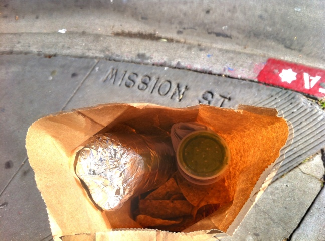
Mission Burrito in the wild
The Mission Burrito (burriticus aluminate) as seen in its native environment:

Wild burritos are most easily caught in a paper bag as they make a nest out of chips and salsa. But remember that they are considerably faster than their domesticated cousins (burriticus chipotlum).
Rock Bar
Behold a golden phone booth on the corner of 29th & Tiffany, heralding the arrival of Rock Bar.

Behold the options in La Lengua’s latest drinking establishment (rumored to be opening this weekend):
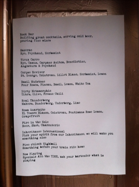
More on Rock Bar in Scoop (via Grub Street SF).