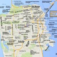
Islands of San Francisco (The Poster)
December 19, 2010
After at least 300 iterations, behold a poster of my San Francisco map — if neighborhoods were islands, and streets canals.
Order on Zazzle — 23″ x 23″ for $25, 15″ x 15″ for $16. 11″ x 11″ for $11.
A bit late to ship for Christmas — why not start a tradition of giving maps in the New Year?

Backstory here for those who don’t remember (or want to savor the 107 comments). But my image of the Valencia Street Canal is what started it all:


I want the 26-Valencia to come back as a gondola!
22 Comments
leave one →


any plans to put this on a t-shirt? :)
It’s on a t-shirt! (I took off the “piers” as it was getting huge and looked off-center.)
Sorry about the cost — Zazzle’s dark t-shirts are really expensive. You can customize it and put it on a lighter, less expensive t-shirt (the background’s transparent) but I’m not sure how good it will look.
Zazzle has a 10% off coupon for t-shirts right now: 10PRCTOFFTEE
Great work!
Please forward to all my friends so they can Xmas gift it to me. Kthxbai.
Tendernob is not a real district and nobody but transplants use that name. It’s called downtown. Use this City map as a guide next time(first google result for SF district map):
http://www.sfarmls.com/docs/areamaps.htm
I’m afraid the time to put those comments in was on the above-referenced post…
And while I appreciate you using Realtors as the end-all resource for geography information, many of them are, well, transplants. I used to resist all those silly new names until I just accepted that even this chick born in the Fillmore (now known as Lower Haight), grown up in a part of Noe Valley a stone’s throw from what this very blog has branded La Lengua and now living in Glen Park (which is what Noe Valley was 20 years ago) can deal with it. Plus, the attention given to including all the very old microneighborhoods by Burrito Justice was so inspiring that he got my vote for SF cred early on. Plus, according to Realtors, the Castro doesn’t exist, right? :-)
Cheers!
TenderNob IS SO an district! Veteran taxi dispatachers routinely use the concept for its practical validity and utility.
Plus, think of it this way… if you lived there, would you want to scare off potential visitors by saying you live on [snif] Nob Hill? Right, dude; see what I means?
It is an district by popular usage over eons or decades of time. True, rascally realtors are ever trying to CHANGE popular usage to suit their misbegotten marketing concepts, and so must always be presumed suspect.
this is awesome
Thank you!
This is awesome! Very nicely done.
Er, is it too late to consider a new detail or two???
First, La Lengua really disserves her own island status.
Second, uh, waddabout the Franklin/Van Ness/Polk Gulch Corridor? [Alternately, the Civic Center-Fort Mason Corridor]… I lived thereabouts for decades and, personally, consider it to be every bit the equal of LA LENGUA.
Viva La Lengua!
Historically, Polk Gulch long preceded its neighbors as a commercial and residential district and was universally recognized as such, even by [urgh] Realtors. The Post-1906 rise of Van Ness as Auto Row cemented a unique character for the entire Pass running from Civic Center to Black Point/Fort Mason.
At a minimum, the Corridor (“Van Ness Corridor” or Franklin-VanNess-Polk Street Corridor) includes both sides of Polk, Van Ness and Franklin from Macallister to Bay Streets. The Fish Woof has taken Aquatic Park to Bay Street. The region from Market to Macallister would be considered contested ground by strategists.
Hordes of Yuppified interlopers from the adjacent Hills combine with massive traffic flows daily to stressify this otherwise bucolic retreat, but, so what?
Viva The Corridor!
Viva La Lengua!
Oceanview, not Oceanside.
D’oh! The OMI monster rears its ugly head… Maybe I’ll start calling it Ingleview to compensate, ha! :-)
Crap, I fixed that in to -view in v3 but the -side snuck back in there somehow. Will fix that later tonight. (Guess the first batch are collectors items now.)
I was intrigued to just find through Google Books search that the “Polk Gulch” name was apparently invented in 1937 for a “wild west” themed event as part of the Golden Gate Bridge opening festivities. Surprising that it has hung on for so long. Time Magazine article from 1939 that mentions it.
ありがとうございます!
ここではサットロタワーです。私は「ゴジラ」は決してそれを攻撃願っていま!!