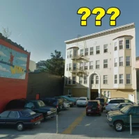
Medjool, Strike 2
Excellent writeup by Mission Loc@l on Medjool’s latest issue — 9 of the 33 units in the hostel are supposed to be SROs (low-income single residence units) and shockingly, Gus Murad never filed the required SRO reports. Innocent error? Well, it looks like there aren’t any SROs. Guess that’s one way to get around the paperwork.
Also, ol’ Gus got sent an interesting letter by the Planning Department on his illegal rooftop bar — apparently he has two weeks to shut it down or appeal.
Craig Nikitas of the Planning Department said he looked into a complaint that Elements was not abiding by its residential hotel requirements several years ago. [Mission Loc@l found documents related to investigations into complaints at Elements, but none regarding SRO rooms.]
Nikitas said that when he looked at the guest registry while he was there, it appeared to him that the nine rooms were, in fact, being operated as residential hotel rooms.
And then he noticed the roof deck.
“We’ve had an enforcement case against the roof deck for years,” he said, adding that a letter saying the bar was illegal and needed to be removed was sent recently to Murad, who has about two weeks to shut it down or appeal.
UPDATE: A spokesman for Medjool said “all the recent attention from the press and seemingly sudden interest in enforcement is ‘unusual’ and ‘curious.'”(Via Eater SF)
Burrito Vigilante Justice
In case you were worried about this blog becoming all responsible and newsworthy… It is best remembered that Burrito Justice is a powerful concept and must be delivered responsibly.
SFist reports there is no such thing as a free burrito:
Berkeley Burrito Brawl Ends Badly (Daily Clog)
Apparently at 4:30 p.m. on Tuesday, a few men got into a fight over free burritos at Juan’s Place near the Berkeley Aquatic Park… and it didn’t end well.
While the police haven’t released the names of the people involved, at least one person is in the hospital after getting beat by a tire iron and a metal pipe.
Contra Costa Times, via CurbedSF:

One hospitalized, two arrested after food dispute (SJMerc)
Berkeley police say shortly after three men walked into Juan’s Place restaurant Tuesday afternoon, they became involved in an argument with employees over free food, which the men often received at the restaurant.
A police spokesman says when two of the three men brandished a knife and a belt, two restaurant workers grabbed an iron tire and metal pipe and beat one of the men.
That man was taken to a hospital where he was unconscious Tuesday night. Two of the restaurant employees were arrested for assault with a deadly weapon.
Given how seriously the employees take their burritos, thankfully the drunken customers didn’t try to stuff the burrito down their pants. That could have gotten ugly. Especially if dressed as a superhero:
Captain America Arrested with Burrito in Pants (PW)
On Saturday night, when a costume party full of medical professionals stopped at On Tap Cafe, police said [Doctor] Adamcik had a burrito stuffed below the waistband of his costume and was asking women if they want to touch it. When one refused, he allegedly took out the burrito and groped her.
The woman called police and, when they arrived, the officers wrote in their report “there were so many cartoon characters in the bar at the time, all Captain America’s were asked to go outside for a possible identification.”
The woman pointed out Adamcik and the burrito was found in his boot. He was taken to the police station. There, while in a holding cell, police said, he asked to use the bathroom and tried to flush a joint, also hidden in his blue tights, down the toilet.
I think the real crime here is how poorly the burrito was being treated. Maybe the good doctor was expecting this response (but that requires knowing who in the bar reads Burritophile):

280, The Last Great American Highway


Go QuadCamera! Love the QuadAnimator for extracting the images into a multiframe GIF. Yet more Japanese software goodness.
Cesar Chavez, the Friendly Road
Plans + diagrams (and damn good salsa and oranges).

Highlights and recommendations:
- Dedicated bike lanes
- Central median with drought resistant trees
- Two lanes of traffic each way
- Dedicated left hand turn lanes (in the middle)
- Parking with permeable pavement
- Wider sidewalks at intersections (bulb-outs, etc)
- High-speed monorail to 22nd St Caltrain (just kidding (I wish))
They have to coordinate with the rebuilding of the sewer, but they are estimating starting early summer 2010.
Pretty impressed with the city planners and traffic folks there. They know their stuff, and were respectfully practical with the Q&A. For example, when asked about wider sidewalks, the presenter responded that sidewalks are ridiculously expensive to make and it would simply blow out the budget allocated to the project. Medians and bike lanes are easier and cheaper (as we saw on Guerrero). And a couple of interesting ideas on taking care of the plants in the median, such as using the day laborers that wait on the north side of CC, along with the storm cisterns that DPW could draw from.
I’d like to see a) timed lights and b) different colored pavement for the bike lanes so distracted drivers would subconsciously notice it like they do a curve or curb.

Found these in an SFMTA doc. Looks like San Jose @ Guerrero is already be on a list:

Then there’s the St. Luke’s meeting next Wednesday at 6:30. This one may be fraught with drama — the people and the city seem to have noticed the street uglification plan that CPMC has pushed through in the dead of night. More detail later, but they seem to want to build the ass-end of a 100′ tower up to the edge of Cesar Chavez and backing right up to two story homes — not exactly the friendly neighborhood walkable feel we are after. I’m perfectly fine with the hospital expanding, but for the love of god make it human, will you?
Cesar Chavez Design Workshop Tonight; Precita Creek Past and Future
As noted by other fine blogs, the meeting is tonight at 6:30 at Leonard Flynn Elementary:

Which ironically enough is the building on the left in this photo from 1940 (looking west on Cesar Chavez / Army @ Harrison — note crazy street alignment was they widened it from 40 to 100 feet…)

And the lovely vista that Cesar Chavez and Harrison is now:

The old Precita Creek went right underneath where the school would go:

Blue is the creek, orange is the old Serpentine Ave, and red is the old Pioneer Race Track. Serpentine seems to have been laid out along an old stone wall that marked the southern border of Potrero Viejo.
Anyway, Precita Creek now runs through a giant storm drain under Cesar Chavez.
Precita Creek was one such arroyo. It fell from “Sun Valley” (south of Noe Valley), was joined by springwater and runoff from Bernal Heights, and at high water cut a 30-foot wide path across the southern Mission District, along today’s Cesar Chavez Street. Its waters dispersed on the way to Potrero Hill, and eventually ended up in Islais Creek’s vast estuarine bog. By the 1860s, the area near today’s Precita Park had become a small village. Some 30 houses lined the creek, drawing their water upstream and using the creek as an open sewer. The marginal water flow in the stream was inadequate to properly carry the sewage off, and as a sanitary measure, the city built the first box sewer.
This sewer was thirteen feet across and ten feet tall, a wooden hallway big enough to drive a carriage through. The sewer was made large enough to carry storm flows–the volume of water that comprised a 30-foot wide creek. During dry season, the box was nearly empty, except for a trickle of liquid at the bottom. A couple years after its construction, an internal inspection found the box to be a stinking mess. Solid wastes had built up where laterals, or residential hookups, connected to the big box. Strange foliage grew in the darkness, fertilized by the human waste and compost that congealed on the floor. Indeed, the ecosystem inside the box was so efficient at removing nutrients, the water flowing out at the east end of the sewer near today’s General Hospital was clean enough to drink.
It was in 1878 that the city decided to straighten out Serpentine, build Army St and build a sewer underneath:
AN ACT TO CONFER ADDITIONAL POWERS ON THE BOARD OF SUPERVISORS OF THE CITY AND COUNTY OF SAN FRANCISCO TO PROVIDE FOR THE OPENING OF ARMY STREET, AND THE CONDEMNATION OF PRIVATE PROPERTY THEREFOR. [Approved March 16, 1878.]
SECTION 1. The Board of Supervisors of the City and County of San Francisco are hereby authorized and empowered… To receive and accept from the owners or claimants of the lots and lands lying contiguous to “Precita creek,” from the Old San Jose Road to the San Bruno road of said city, a deed or deeds of a tract of land, not less than sixty-four feet in width, and without abrupt curves or short angles, to be located on a line to be located by and to be satisfactory to said Board of Supervisors, for the construction of a sewer therein, and for the purposes of a public street.
In this 1888 photo, overlooking Mission from Bernal, you see the new Army St. You can just make out the Valencia and Mission St bridges going over the creek coming down from Twin Peaks.

(Anyone have a better resolution scan of this photo?)
It took a while to get the people to hook up to the new sewer however, despite the threat from diptheria (nearly 1000 children died in an 1876-77 outbreak.) From the 1889 San Francisco Municipal Report:
During the past year I have designed a system of sewerage for a district covering from five to six hundred acres, embracing portions of the Potrero and Mission. This, I venture to say, is about the only district in San Francisco that has a thoroughly designed system, and where any attempt has been made to carry out the details. In referring to this matter I would respectfully call the attention of your Honorable Body to a point in this connection which I have spoken of before your committees, namely, the necessity of opening Potrero avenue trom the old line of Serpentine avenue through to Army street. This is necessary to complete the drainage system referred to, as there is no other available method of disposing of this sewage, and as it at present will discharge in front of private property. Arrangements cannot be made too rapidly for its accomplishment.
Rainy 280
I think I am the only person in this city excited about all this rain.


Taken with QuadCamera on the iPhone — great little multi-shot time lapse app by Takayuki Fukatsu.
I’ve found that the Japanese apps are just damn solid. Check out this free stopwatch timer, Big Stopwatch, by Yuki Yasoshima. Just fucking gorgeous.

So Wide These Streets Can Be
As Gillian of Greening Guerrero notes, in the 50s, the houses on the east side of Guerrero were moved into their backyards to widen the street from 60 to 100 feet to make way for the Mission Freeway (thankfully stopped before it got started). Cesar Chavez/Army got blown out as well from 40 to 100 feet. The neighborhood has suffered since.
While a lot of work has been done in the past 5 years…
- Guerrero is now two lanes in each direction instead of three
- Stoplight at 27th and Guerrero
- Trees and plants in the middle of Guerrero
…there’s still a lot on the list — here’s a resolution passed unanimously by the sups in 2004.
All the more reason to attend the Cesar Chavez Design Workshop this Tuesday at 6:30 pm at Leonard Flynn Elementary School, Auditorium (3125 Cesar Chavez Street). And don’t forget the CPMC Community Meeting on March 4th at 6:30 in the St. Luke’s Cafeteria to address the new expansion plans.
For some context, here are some shots from the SF Public Library of Guerrero in the 20s and 30s, compared to current photos via MapJack. Click on any picture to get to the source.
1928, Guerrero @ 27th, looking south:

Today:

1932, 27th @ Guerrero, looking east towards St. Luke’s:

Today:

Note the staircase on the white apartment building — even with the houses moved back on their lots and narrower sidewalks, all the front stairs along that side of Guerrero had to be jammed to the side of the houses.
1931: Looking north on Mission @ Army (the old Sears building would be over your left shoulder)

Today:

The Walgreen’s construction site is on the left hand side — retail before, retail again. Hey, the Palace Steak House is in that 1931 shot! (Just kidding.)
1940, Army between Valencia and Guerrero (can’t for the life of me find a matching picture for this one — if I’m not mistaken, all those buildings were torn down when Army got widened.)

UPDATE – this is between Valencia and San Jose — you can barely see the Salvation Army building in the top right corner. (This was before the Salvation Army bought the lot and cut off San Jose.)
Army looking west towards Guerrero, 1962, now more than twice as wide. The liquor store on the left hand side is on the corner of San Jose and Army. (Source – 1962 Dept of Public Works, via G. Gillet)

The store and all but three of the houses were torn down to make the St. Luke’s surface parking lot, resulting in a rather bleak street. (St. Luke’s also has a rather empty multi-story parking lot on Duncan…) At least there are trees. (Which I am sure will be cut down if St. Luke’s builds a 2nd hospital tower on that lot — but more on that later.)

Anyway, if you’ve read this far, you obviously care about La Lengua — consider attending the Cesar Chavez Design Workshop this Tuesday, the 26th, as well as the CPMC / St. Luke’s meeting on Wed, March 4th.
Mission Freeway, 30th St BART
One of my favorite new map blogs, The Map Scroll, recently covered the thankfully failed effort to criss-cross San Francisco (and other cities) with freeways and the “freeway revolt” against this in the 1950s and 60s. Many excellent sites discuss this one already, especially Shaping SF.
Anyway, the Map Scroll got me a-googling for better resolution map of that birdseye view of the planned highways, especially the Mission Freeway that was in the works (basically more of the 280 San Jose exit, pretty much up Capp St (between Mission and Van Ness) to 14th). Wikipedia to the rescue. (Click below for a giant map of the whole city burdened by albatross-like freeways.)

My house would have been so under the Mission Freeway that even Tom Petty wouldn’t have been able to sing songs about it.
Summarizing Shaping SF: protests by the Haight-Ashbury Neighborhood Council led to the Chronicle printing this map in 1956, resulting all hell breaking loose — even though the map had been around since 1948. (For you younguns, newspapers (those wet, soggy things you saw in bags on the sidewalk this past week) actually used to break stories before most people knew about it! Shocking, I know.)
But fear not, there was a mean streak in the Chronicle even back then:
On November 2, 1956 the San Francisco Chronicle graciously published a map of the proposed and actual freeway routes through San Francisco even though its accompanying editorial was already chastising protestors: “The remarkable aspect of these protests and claims of injury is their tardiness. They concern projects that have for years been set forth in master plans, surveys and expensive traffic studies. They have been ignored or overlooked by citizens and public official alike – until the time was at hand for concrete pouring and when revision had become either impossible or extremely costly. The evidence indicates that the citizenry never did know or had forgotten what freeways the planners had in mind for them.”
Other exciting SF never-built freeway features included a highway through Glen Canyon and a second Bay Bridge at the foot of Army. Kind of amazing BART got built under these circumstances.
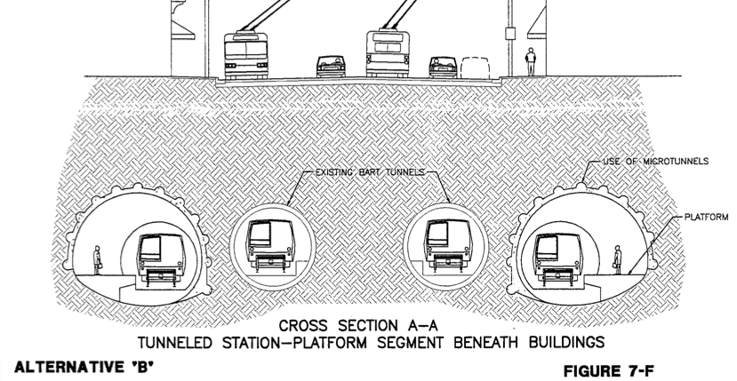
I still want my infill BART station at 30th though — La Lengua‘s easily worth half a billion of stimulus funds! PDFs on BART’s planning website (part B has all the construction porn). Bored tunnel, not cut-and-cover (like the rest of Mission was done), estimated 3.5 years of construction time, with just 11 months of traffic distruption, and a huge hole in the Safeway parking lot and Valencia/29th to get the dirt out and cement in. All for beautiful entrances at 29th and 30th, and a nice new building for El Patio! It could be our Carlo’s, where commuters are welcome…

SF Cityscape has an extensive bay-area transit map of the future.
And here’s the preferred dual tunnel that would allow express trains:
Now for that second Transbay Tube and offline tunnels for more stations. Simply shouldn’t take 30+ minutes to get to the airport…
Google Earth Captures 25th @ Osage Block Party

http://www.sfmta.com/cms/ciscott/ISCOTTAgenda04-26-07.htm
25th Street between Mission and Bartlett Streets; Intersection: Osage Alley @ 25th Street
Saturday, June 9, 2007, 7 AM to 7 PM
Neighborhood Block Party
Burrito Poll – Do You Dare?
The brave souls at Mission Loc@l have burst past that which is unspoken… whatsyourfavoriteburritoplace.
Can’t hear you, what’s that? Yes, they put up a burrito poll.
Main page, center-right. Let the debate begin. Hope your webservers are strong, Mission Loc@l.