Do Not Fail High Speed Rail
California needs high speed rail for so many reasons. Given I-5 and LAX, how can you seriously push back on 2 hours and 40 minutes to LA, allowing for a couple of beers at 220 mph and then a nap?
But I’m truly surprised by those who push against it. I grow tired of NIMBY selfishness in Palo Alto / Menlo Park and childish op-eds in the New York Times and the Washington Post (or even the SF Chronicle or LA Times). And who knew highways magically grew from the soil without any sort of government subsidy?
Anyway, it was refreshing to see the The Sacramento Bee publish a solid editorial with an utterly brilliant diagram comparing California’s future HSR with that of France.
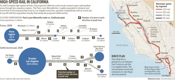
This diagram is just gorgeous and to the point. But as much as I love the TGV, an even better comparison to California is Spain and AVE between Madrid and Barcelona. It’s almost the same distance and time as the CAHSR plans, and the two cities are much closer in size than Paris-Lyon.
I was going to make a diagram for Spain in the same style as the Bee’s, but I realized that most people don’t realize how big France and Spain are compared to California. So behold a quick map of the three regions and HSR-relevant cities I whipped up in OmniGraffle.
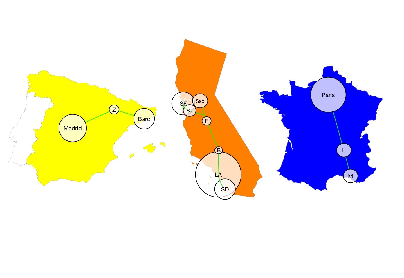
(Geographic regions are to scale, and the metro population circle sizes are a bit of a wag, but all are relative.)
With population density like ours, and the success of TGV and AVE, how do you claim with any intellectual credibility that HSR won’t work here? It’s a significant amount of money, but it’s an investment, and the alternative is worse. You’re not going to make I-5 any wider, or add more runways to SFO or LAX.
While I’m at it: the utter moral bankruptcy of those using “train to nowhere” to describe the first planned segment between Bakersfield and Fresno is maddening. You know where they build the first bit of Interstate? Missouri. And the first BART line? Oakland-Fremont. Just stop moving your lips, you are embarrassing yourself. (This includes you, The Economist – your article was weak sauce. Sad, even. And you really ought to drive out of LA up I-5 on a Sunday sometime. Or any time.)
And don’t get me started on the haters in Palo Alto – their hypocrisy is stunning given the town was founded by a rail magnate.
Anyway, here’s to more sensible discussions on how to make HSR in California the best it can be, rather than killing it and California’s future.
To The Moon!
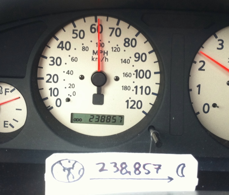
At 75 mph, it would take you 4 months to drive to the 238,857 miles to the moon.
Also, for some perspective, the Space Shuttle and International Space Station orbit just 190 miles up. The moon, so far away from me.
So where’s my damn space elevator? Or better yet my sling-on-a-ring – imagine an ring of tethered satellites orbiting the earth, with modules that drop a line down *vertically*, pluck a ton or cargo from planes at 40,000 feet and jerk it into low earth orbit. I don’t know how many Gs that would be, but GODDAMN I want that.
California Below
All hail the gods of data recovery! I was able to salvage my recording of the International Space Station flying over San Francisco on May 3rd at 2:45 PM. While animated GIFs are fun, giving you that vintage 1960s Mercury feel, smooth video from a fully operational space station 190 miles up is even better.
Better still, I was able to rotate the video “earth-down” for your viewing pleasure (as much as I liked the guy from Poland who said “Ziemia błękitna nade mną…”, or “blue earth above me…” (The earth-on-top original is here if you are so inclined.)
5 miles per second never felt so smooth.
The first few minutes are about 1000 miles of the Pacific ocean and clouds – remarkably therapeutic if you ask me. (If the epic build is too tranquil for you, California starts to appear 3 minutes in.)
Here’s the GOES-West visible satellite image from that afternoon:

If you look closely, you can see the same cloud patterns from the video — the wishbone-shaped one (orange circle in the crop below) and the line of clouds (marked in yellow) are easiest to match up. The green dotted line is the path of the ISS.

Glorious as the live ISS feed is, 640×360 is pretty raw. (And while the all powerful VLC was a key tool in capturing this video, holy crap is transcoding rough around the edges.)
All we need now is to petition @NASA to install permanently mounted HD cameras on the ISS — one forward, one straight down, and one aft. A downward cam with zoom would be nice too.
And a schedule of when the video is expected to go out would be rather lovely, along with an archive — maybe the past day or so? I do believe these would be justified usage of valuable tax payer dollars.
Dude, Where’s My Car?
Disturbing news: the white Jeep Cherokee of TK (aka @4ogoingon28) HAS BEEN STOLEN.
While TK has provided some helpful suggestions as to the potential location of his vehicle based on its personality, I suspect something more sinister is in order: TIME TRAVEL.
I just happened to be watching the Planet of the Apes, and what do I see?

It’s been a while, but apparently time, space and sand have all shifted:

On the off chance that some sort of horrible rift in the time space continuum ALSO sent TK’s car into the past (like Calvin sitting the wrong way in his cardboard time travel box), I ordered the Burrito Justice Historical Resource Unit to check into historical archives.
Check out this photo I just found in the UC Berkeley historical archives!

Zooming in a little, we see that TK, not the earthquake, was responsible for one of Valencia Street’s great tragedies.

Sorry, TK, either Charlton has it, or it’s buried deep within the Valencia St Gulch. Time to buy a hybrid.
Looking Down on California
So I’ve been noodling around with recording the video from the rather lovely streaming video feed from the International Space Station. The direction is an utter crapshoot. Sometimes it’s straight down, sometimes it’s pointed in some random (yet pretty) direction. When they’re orbiting over some random country, this is great, but when it’s over California, it’s stress inducing.
On Sunday, the ISS passed directly over SF (well, San Mateo, but hey, 87º vs 90º overhead, I was not complaining). The sky was far too bright for us to see it — I think something has to be magnitude -4 to be visible during the day, but the ISS rarely gets above -2 or -3. But it could see us.
So Sunday at 5PM I’m all geeking out with VLC and trying to explain to my 2.75 year old daughter why she can’t watch Elmo or hockey, and that daddy is conducting Important Science. She sat on my lap and humored me while I transcoded video from an .asx feed to .mp4 and got a lovely view of the Pacific Ocean with North America creeping slowly towards us.
However, some astronaut (all of whom I love dearly) had decided to POINT THE CAMERA TO THE HORIZON AND TO THE LEFT OF THE DIRECTION OF TRAVEL. When they were going directly over us. On a sunny, fogless day. Which means SF wouldn’t be centered. Needless to say, I was conducting a dynamic inner dialog, but hey, what can I do as I’m no astronaut and am highly entertained by any sort of pictures from space, never mind video.
So here’s what they saw of us – the camera barely caught us in the top-right corner.

And here’s a link to the elegant and calm-inducing video over at TwitVid (note to readers – uploading video to TwitPic seems to be an exercise in futility. And yes, I flipped the picture, so SF is in the bottom left in the video. Sorry that it gets jerky over Nevada, transcoding on the Mac doesn’t seem all that solid.)
My annotations. I was really surprised by the number of contrails. The ones from Seattle/Portland/Vancouver are obvious, and I suspect the ones in the middle are from China/Japan to LAX. Not quite sure where those two on the right are from. Hawaii?

Anyway, I am undeterred and persist in my SF-ISS video quest. I use my trusty Satellites iPhone app and n2yo.com to figure out when the next daytime pass is. Tuesday at 3PM, awesome! Of course, everything goes wrong — I’m at work, I lose track of time and I don’t have my regular computer with me, so I have to quickly install VLC on some POS PC and hope the recording works. And I end up with a 15MB file that doesn’t open. (Rant: dear video people — your containers suck. .ps? Seriously?) Anyway, even the almighty VLC (which created it) can’t open it, but I digress.
But if you are brave and want to try to convert the mpeg encoded .ps file of mystery, please have at it. (I can see a few frames in mplayer, but nothing else I have (even Handbrake) can open it. VLC experts said they could play it in mmplay.)
Of course, being utterly paranoid, I took a bunch of screenshots which I was able to jam into an animated GIF, the BEST FORMAT EVER DEVISED BY MAN. I’m telling you, 1.5 million years from now, intelligent penguins will be using animated GIFs. Animated GIFs are the cockroaches of image and video formats. Historians will love this shit. It. Just. Works.
SO BEHOLD, a jerky animated GIF of the International Space Station passing over California, making a beeline for San Francisco. (Hint — look for either Monterey Bay and look right, or Pt. Reyes and look left.) Frame rate slowed at the end for dramatic intent.

I’ve enhanced the money shot and rotated it to tradition N/S in case you are still horrifically confused.

Makes that drive to San Jose look short, eh? I’m rather surprised how grey that SF / the Peninsula / Valley / East Bay looks. Hi snowpack! Anyway, if I get the video figured out, I’ll upload it. Awesome as animated GIFs are, the smooth video and dramatic revelation of San Francisco Bay is rather lovely.
Hey, @NASA, not that I don’t love this feed, but how about a few HD cameras with zoom? One with the oblique shot, one straight down, and one aft?
Oh, hey, I almost forgot, here’s timelapse shot of the ISS passing to the south of SF around 9:35PM this evening. It moves pretty damn fast — that’s a one minute exposure.

And the Big Dipper, just because.

Coronorama
Full 360 from the top of Corona Heights. Click for 10,200 pixels that go round, round, right round.

Also a fun little 360 gyroscopic (at least on the iPhone / iPad) view I took via Occipital.
 .
.
Dolores Spring
Nice day today, spring has sprung, etc. Perfect for a panorama. Here we have 16 or so iPhone pix jammed together using AutoStitch (chops things up into cubes and aligns them – takes a while but some nice results).

As usual, click to zoom. Here’s a slice from Transamerica to the Bay Bridge, the playground and ghostly sidewalkers:

I strongly recommend you go see Christopher Richards, Curator of Aquatic Biology at the Oakland Museum of California, speak tonight at 7:30 on the lagoon that wasn’t:
Here’s another chance to hear Christopher Richard’s story about the founding of San Francisco and the mythological Laguna Dolores. The historical maps provide the foundation of the argument, supplemented by journals of the early founders. An understanding of water and landscape is key. He’ll bring maps and sources to inspect, so you can check it out for yourself.
Christopher’s story was well presented in the Mission Loc@l blog by Hadley Robinson (ed: hooray!), and misrepresented (ed: grrrrr!) in the SF Chronicle by Carle Nolte (corrections follow in the comments).
It’s part of the Randall Museum’s natural history series. The Randall Museum is at 199 Museum Way (at the top of Corona Heights).
Christopher Richards is an excellent and entertaining speaker, and his slides are great. There was some serious drama between the Jesuit priests and the Spanish soldiers leading the expedition.

(If you can’t make it tonight, “The final presentation of this lecture will be at Mission Dolores on June 25th, in the afternoon.”)
Sunset over The Bay
The bridges over San Francisco Bay at sunset, via The View From 6A:

(Cropped — slightly wider original over at 6A.)
I See ISS, ISS Sees You
Every 91 minutes, the International Space Station orbits the earth, some 190 miles above our heads.
You can see it pass over quite often, and (fog permitting) tonight is one of those nights. From about 8:10 to 8:14, the ISS will pass over California, and from San Francisco’s perspective it will be quite high in the sky — 61 degrees up, to the southwest / south. (It will be even higher in the sky in the south bay, and directly overhead in Monterey.)
But what does the ISS see? Quite a bit. A number its residents are on Twitter and are taking photos. Last year, @astro_soichi, a Japanese astronaut, took this rather glorious photo of us:

Right now, @astro_paolo, an Italian astronaut, is taking some epic pictures as well. The ones of the squished moon (distorted by the earth’s atmosphere) are pretty awesome.
Satellites is a rather awesome iPhone app ($1) that shows you where the ISS is and will be. You can also ‘play’ the orbits forwards and backwards in time. Below we see tonight’s pass. The orange circle is the visible horizon of the ISS. The orange line indicates the visibility of the ISS from the ground after sunset and before sunrise. (If you are iPhoneless, or want to see other satellites, n2yo.com is a pretty good resource with a nice Google map view).

(When over San Francisco, astronauts and cosmonauts can see from Vancouver Island to Baja California.)
A closeup view of the California pass:

Even better, NASA is currently streaming live video from the ISS, and more often than not the camera is pointed down at us. Here’s a shot over Paupa New Guinea at their sunrise a few hours ago:

(Beware that the stream is an .asx / mms and doesn’t work very well in Safari — use Firefox or VLC if you have trouble.)
Even if it’s dark, you may see city lights. And since the ISS travels 4 miles a minute it will come out of shadow in no time. (In the Satellites app, you can maintain perspective on the ISS and fast forward through time — it’s pretty trippy.) If you just see a static shot of the horizon, the ISS is likely out of satellite/ground coverage over the middle of the ocean.
Anyway, just after 8, we can see how the ISS sees us (or at least Monterey/Santa Cruz — I am not quite sure of the field of view yet). Whether we see *it* is up to our friend the fog. (And of course, the ISS may just see fog too. Stupid fog.)
UPDATE: No fog! But despite a fairly thick high cloud layer it was very bright, very high in the sky. A quick shot through my iPhone and binoculars here, and a better shot through my Lumix below.

But the NASA ISS stream was down! Oh, the irony.
There’s another pass on Thursday starting at 7:23, even higher in the sky — reaching 70º at 7:26. Should be pretty bright, but it moves far faster than you will expect. Hopefully the NASA video stream will be up this time.