Nautical Disaster
Regular readers will recall the story of the King Philip, the Clipper ship which ran aground off Ocean Beach in 1878 and the remains of which can sometimes still be seen.
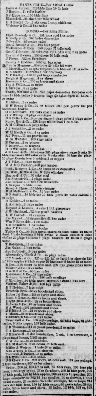
Thanks to the California Digital Newspaper Collection, we can see manifests of the King Philip and other ships of the era. Here’s the manifest from 23 July 1859. Basically anything interesting came around the horn. I don’t know what’s more surprising, the quantity or how many different things were on one ship.
Pianos. Soap. Fireworks. Rum. Whiskey. Wagons. Nails. Shoes. Books. Sheets of pig iron. Barrels of salt pork. Hops.
Speaking of hops, I am kind of surprised there is no beer on the manifest. The King Philip sailed from Boston, so perhaps it wasn’t a big beer town? But regardless, they certainly seemed to have everything else. (Another project would be to compare ships manifest before and after the Transcontinental Railroad made it through in 1869. But I digress.)
Now, I know you are thinking, “But man cannot live on barrels of whiskey and rum alone! One needs a good beer on occasion!” Thankfully porter and ale were shipped from London in great volumes.

For reference, “HHDS” is a hogshead, which was about 63 gallons, which is 63 * 128 = 8064 oz, or the equivalent of 672 bottles (times 100). So the Southern Eagle carried the equivalent of over 11,ooo six-packs across the Atlantic, around the horn, up the Pacific to San Francisco. (It also carried coal, pig iron, wine, champagne, and port.)
I’m still surprised at how much beer was shipped in to town given there were at least a dozen breweries as we can see from the 1859 city directory in the Herrick/Hoogs San Francisco Almanac:

Just to show you how quickly things were growing in this era, the 1859 Langley directory shows says there were 18 breweries, including the fancy new “Philadelphia Brewery” on 2nd & Folsom:

Here’s a list of all 18 listed here along with an ad showing what the area may have looked like:

Here’s 2nd and Folsom on the 1859 Coast Survey map. If the brewery was on 2nd, and the hill is sloping up to the left, then are we looking southwest, at the block bounded by Harrison and 3rd? Note this was the Rincon hill cut out by developers in the 1860s.

But as you might expect from a bunch of Philadelphians, the Daily Alta reported that they were dumping “offensive effluvia” all over the place:

And in one of those historical coincidences, check out the ads next to this article:

England was quite the beer shipping center, especially to India, as we can see in this report for the good ship “Edwin Fox” from 1860.
February 14, 1860

The ship sailed for Bombay. Included in the cargo was a substantial quantity of "Taylor Walker's India Pale Ale". It was to be the first of several voyages in which she carried alcoholic beverages to India and earned the name the "Booze Barge". British pale ales for the Indian Empire were made to a higher than normal strength, and given more hops, to protect them on the journey.
This is from the New Zealand Maritime record, a rather amazing collection of shipping records from the NZ National Maritime museum. (Alas the tale that IPAs had higher alcohol content to survive the journey is not true — porters and stouts also made the journey.)
But I bring you TRAGIC NEWS from the year 1869:
August 12, 1869

The [Edwin Fox] ran aground on the Coromandel Coast at 2 a.m. With assistance unavailable, the Master ordered 107 tons (446 hogsheads) of India Pale Ale jettisoned. The ship then drew herself out of the mud and reached port the next day.
That’s the equivalent of nearly THREE HUNDRED THOUSAND BOTTLES OF BEER THROWN OVERBOARD OH THE HORROR
The history of the Edwin Fox is pretty fascinating — it was built in India in 1853 and made of teak. After its days of shipping IPA to India, it served as an Australian prison ship. Afterwards, it took colonists to New Zealand and also made ports of call in San Francisco in the 1880s. The teak hull is still afloat in Picton, New Zealand today.
While we’re on the topic of ships near Picton, New Zealand (why yes, I do spend all day reading the New Zealand Maritime Record — don’t you?) there’s quite a shipwreck in the Marlborough Sounds (which is a ridiculously cool looking area as this photo by @yorrike attests):
http://twitter.com/Yorrike/status/139633578987360256
In 1986, the Soviet cruise ship Admiral Lermontov (yes, a Soviet cruise ship) was sailing too close to shore, hit a rock, ripped a 40 foot long hole in the hull, lost power, listed and then sank. (Sound familiar?)
While the Soviet captain didn’t schettino, they were not exactly jumping to get word out there was a hole in the boat:
Presumably, because of language problems, no announcements were made to passengers to advise them of the position and tell them what to do, although many passengers were alerted to the problem by the fact that the crew were wearing life-jackets.
In the meantime there was an announcement that dinner would be delayed an hour and the wine tasting session that was in progress would be extended. The band continued to play, but the wine tasting stopped when the list sent glasses sliding off the tables.
Only one person died (a Soviet engineer below decks), and the wreck is a popular diving destination today (though three divers have gotten stuck and died within the wreck). I do not know what sounds worse, dying on a Soviet cruise ship while it is afloat or getting stuck on one underwater.
That being said, they had quite the lounge and bar scene, as photos from the New Zealand Maritime Record report on the sinking (including a couple of before and after shots):
 |
 |

But even the Nevsky and Neptun bars are not enough to get me on a cruise ship. (That and the data roaming charges.) I’d rather take a schooner to Vladivostok:

Damn the torpedoes!

And don’t forget that Russian Hill was named for Russian sailors buried well before the Gold Rush era. It’s not clear what year, or what ship, or even if the graves were moved.
| 1861 | 1862 |
|---|---|
 |
 |
Hittell in his 1896 History of California states that “a few graves, surmounted by black crosses and bearing Russian inscriptions” were visible as late as 1849:


I’ve found copies of Burnett and his recollections of 1849 San Francisco along with El Dorado and Taylor’s story of his trip to San Francisco in 1849 (in vol 1). Here’s Taylor’s description of Russian Hill is in volume 2 that Hittell used, but with some more detail:

(But whatever you do, DO NOT CLICK ON THIS LINK OR THIS ONE OR THIS ONE. OR YOU WILL BE READING IT FOR THE NEXT 3 HOURS. Don’t say I didn’t warn you.)
Burnett’s Russian Hill reference is from a poem, and other than a false lead on a name of a ship, not all that exciting.
"THE CITY’S DEAD: Another spot, selected at as early a date as 1842, was the eminence between Taylor and Jones streets, and north of Vallejo street. Here were buried several of the crew of a Russian vessel, stricken with some malarian disease, which occupation of the hill by them resulted in the name of Russian hill being applied to the spot. Not many additional burials were made there, however, as it as considered too inaccessible for funeral corteges, and in 1850 it was abandoned and the remains of those placed there were afterwards removed to other localities. . ."
And I just found an 1851 reference in a proposal for new reservoirs:

The Russian Consul of SF seems to think it wasn’t entirely removed in 1860…
..The Russian cemetery that gave Russian Hill its name was located on the crest of the hill above Taylor between Green and Vallejo. The exact site is now a ramp and staircase on the corner of Jones and Vallejo. There has been much speculation as to the origins of this cemetery and why the Russian Fur Company chose this spot to bury their dead in the 1830s. The cemetery was San Francisco's second burial ground; the first was at Mission Dolores. The Russian cemetery was used during Gold Rush times, but was gone by 1860. In 1917, workmen excavating the Leavenworth Street slope are said to have found human bones there....
… and they were from a ship belonging to the Russian Fur Company (they of the Russian River and Fort Ross) rather than a warship. If so, it may be one of those listed in the ships that came to Spanish/Mexican California, with dates and ship’s master.
- 1806 – Apr 16 — Juno (Resanoff, master), SF
- 1816 – Rurick (Kotzebue); Oct 15 – Rubio, Kalzule; Sept 16 – Suvarof, Chirikof, Ermenia, SF
- 1817 – Russian Naval Officer Padushikin, in small boats
- 1823 – Buldakov
- 1824 – Buldákof (Jan 8, Aug 12)
- 1825 – Elena (Oraviof), Kiahkta
- 1826 – Argony (Inestrumo), Baikal (Benesman)
- 1827 – Baikal (Etholin), Okhotsh (D. Zarambo)
- 1828 – Kiakha
- 1829 – Kiahkta, Baikal (Benseman)
- 1831 – Baikal (Livovich)
- 1832 – Urup (Zarembo)
- 1833 – Baikal (Livovich)
- 1835 – Sitka (Basilio Wacodzy)
- 1836 – Sitka (Basil Wacoocky)
- 1837 – Baikal (Jan, Stephen Vouks), Sitka (Oct)
- 1838 – Sitka (Oct-Nov, Wacoocky)
- 1839 – Baikal, Elena (Vallivode, Sept)
- 1840 – Elena (S. Vallivade), Nikolai (Oct-Nov, Kuprianov)
- 1841 – Elena (Feb)
- 1843 – Naslednik Aleksandr (spring)
- 1844 – Naslednik Aleksandr (fall)
- 1845 – Baikal (Oct-Dec), Naslednik Alexander (Oct-Nov)
- 1847 – Naslednik (Oct)
Note that some of these visits were from the four ships built at Fort Ross — the Rumianstev (1818-1823), Buldakov (1820-1826, the Volga (1822-1827) and the Kiakhta (1824-??).
And there’s a scary amount of ship detail in Mr. Bancroft‘s footnotes in his History of California – here are the Russian ships that came to San Francisco from 1836 to 1840:

And for those of you who read Two Years Before The Mast, here are the ships that Richard Henry Dana Jr. came in and left on (1834-1836):

Note that the Russian-American Fur Company decided to leave California in 1839 and sold Fort Ross it to Captain Sutter in 1841, leaving completely in 1842. There were a couple of ships still trading along the coast after Fort Ross was shut down, including the Naslednik Aleksandr that carried I.G. Voznesenskii, a Russian scientist.

Hmmm, that narrative sounds interesting. Hey, it was by a “professional writer”! Alas all the versions I see are behind paywalls.

I initially thought a Russian ship might have buried crewmates in SF once the colony at Fort Ross was gone, but it seems as time went by the crews on Russian ships in the Pacific were mostly Finnish and “from 1840 onwards the Company’s around-the- world ships were manned entirely by Finnish merchant skippers and crew” (thus mainly Lutheran). The Naslednik was even built in Finland.
So unless there was a Russian naval ship that stopped in the 1840s that’s not in these records, I think we’re looking at one of these trading ships before 1841. This presumes of course that it wasn’t just burials from one ship. Or maybe a bunch of Finns are buried there. I can see real estate values plummeting if we have to rename it to “Finnish Hill”. (Kidding, I like the Finns, they make good goalies.)
There are surprisingly few references online to the cemetery. The Online Archive of California lists a “Early view of Russian cemetery on Russian Hill [Vallejo and Taylor Streets]. Photograph of a painting. 1820s” (Volume 2:63) but it’s not online. Grr.
Unfortunately, there’s no sign of the cemetery in either the 1853 (top) or 1859 (bottom) Coast Survey maps (I added the red cross to show where most records seem to think it is), but regardless you can see the city starting to spread westward.

Calisphere has a couple of photos of Washerwoman’s Lagoon taken from between the two peaks of Russian Hill. This one is supposed to have been taken in around 1866 (plus or minus 4 years) from Leavenworth and Green — if so, the graveyard site would have been a block behind the photographer (towards the slightly taller Russian Hill).

It’s hard to match up the view on the 1859 Coast survey map (remember it was surveyed in 1857, so it could have been easily 10 years out of date. I tried estimating the field of view — I cannot match that big house with the fence, but the lay of the land seems right to me.)

This next one was taken further to the west, several years earlier (between 1859 and 1862), on the far side of the hill you see in the top photo, (the one marked as 314′ ft in the 1859 Coast Survey map) — I mainly include it because it’s cool, and if you can match up a lot of buildings on the 1859 map. I’ve tried to overlay the approximate field of view:


And that’s enough for now. Time for an IPA.
Trackbacks
- From Russia with (no) Love « Burrito Justice
- Web Bites – Napoleonland, Hidden East Village Theater, SF Shipwrecks « Untapped Travel
- Web Bites - Napoleonland, Hidden East Village Theater, SF Shipwrecks
- Edwin Fox IPA « Burrito Justice
- A Sad Day for IPA | Burrito Justice
- Калифорния Dreaming | Burrito Justice


Brilliant! I, also, am surprised that beer was coming from .uk but not from the East Coast. Odd.
Interestingly, according to Wikipedia the reason that the Edwin Fox is not being fully restored as was originally planned is not because of cost, but actually because teak timbers of the size required to do so are just not available any more.
There are some nice Lermontov dive videos on YouTube.
more great historical ramblings. Love these posts!!
Perhaps this “offensive effluvia” was running downhill on second street to the corner of Howard St, which is a natural decline. maybe they were just dumping shit into the gutter and it all piled up at the lowest point around, 2nd & Howard. I’m picturing a giant puddle of frothy, hoppy, effluvia.
Excellent reportage! And a whole slew of new data sources to peruse – fantastic stuff.
Curse you and your fabulous data sources! California Digital Newspaper Collection? Now how am I supposed to get anything else done?
…and what other gems are out there?
this post may represent the pinnacle of internet content
Update:
– added ad and map for the Philadelphia Brewery
– added maps, articles and ship lists for Russian Hill graveyard
I look forward to your book, JohnnyO
Wow, this is getting long!
– added more detail on Russian ships
– Russian ships were largely crewed by Finns. What if Russian Hill is actually Finnish Hill? :)
Man what a great article. I am blown away by the details you uncovered.
“Pianos. Soap. Fireworks. Rum. Whiskey. Wagons. Nails. Shoes. Books. Sheets of pig iron. Barrels of salt pork. Hops.” <<<< Could also be the contents of Janis Joplin's purse?
http://thehairpin.com/2011/01/what-was-in-janis-joplins-handbag
Now that we’re no longer relying on months-long deliveries, I enjoy a fresh pilsener. Session beers are my fav. The trend for high-alcohol craft beers is killing off the customer base.
Update:
Added a few 1849 references to the Russian Hill cemetery (but still no details on ships — I suspect I’m going to have to dig into the pre-1848 Mexican records.)
This is an epic post!! My maritime history libido is out of control!
Was the manifest for Vladivostok (under the Neptun bar pictures) from San Francisco…or England?
Thanks! That was from SF, 1885 or so — links to the original articles are embedded in the clips, need to make that more obvious.
Funny part is those were a throwaway in the first draft in a desperate effort to being the article back home. Then I started digging into Russian Hill, and well, several dozen hours and thousand words later…
But man do I want to find the name of that Russian ship though.
This post contains: A Superior Article Of BEER
“This one is supposed to have been taken in around 1866 (plus or minus 4 years) from Leavenworth and Green” No, no and no. I grew up near there and can debunk that statement. Here’s a picture of Green and Leavenworth:
That picture was probably taken from around Vallejo and Jones, about where Russian Hill Place is today. That means the caption is correct as far as the location of the cemetery.
The second picture is taken from around the site of Sterling Park, bounded by Greenwich, Lombard, Hyde and Larkin. I believe that’s Larkin Street at the foot of the hill in front of the house.
What a wonderful site you have created for students of San Francisco history. Thank you.
whoa! never seen that picture before. thank you, let me take a look at this and wrap my head around it.
Of course I forgot to mention that the Octagon House is in the left side of the stereoscopic picture of Green and Leavenworth that I linked to. It’s in the 1000 block of Green today. In case the picture doesn’t open, here’s the link with the http:// stripped out:
commons.wikimedia.org/wiki/File:The_Presidio_and_Golden_Gate,_from_Russian_Hill,_San_Francisco,_by_Thomas_Houseworth_%26_Co._2.png
Happy Edwin Fox Day! The NZ Maritime Record went offline sometime in the last decade but here’s the Internet Archive to the rescue, will fix the links one day
https://web.archive.org/web/20230127193820/http://www.nzmaritime.co.nz/edwinfox.htm