Mission Freeway, 30th St BART
One of my favorite new map blogs, The Map Scroll, recently covered the thankfully failed effort to criss-cross San Francisco (and other cities) with freeways and the “freeway revolt” against this in the 1950s and 60s. Many excellent sites discuss this one already, especially Shaping SF.
Anyway, the Map Scroll got me a-googling for better resolution map of that birdseye view of the planned highways, especially the Mission Freeway that was in the works (basically more of the 280 San Jose exit, pretty much up Capp St (between Mission and Van Ness) to 14th). Wikipedia to the rescue. (Click below for a giant map of the whole city burdened by albatross-like freeways.)

My house would have been so under the Mission Freeway that even Tom Petty wouldn’t have been able to sing songs about it.
Summarizing Shaping SF: protests by the Haight-Ashbury Neighborhood Council led to the Chronicle printing this map in 1956, resulting all hell breaking loose — even though the map had been around since 1948. (For you younguns, newspapers (those wet, soggy things you saw in bags on the sidewalk this past week) actually used to break stories before most people knew about it! Shocking, I know.)
But fear not, there was a mean streak in the Chronicle even back then:
On November 2, 1956 the San Francisco Chronicle graciously published a map of the proposed and actual freeway routes through San Francisco even though its accompanying editorial was already chastising protestors: “The remarkable aspect of these protests and claims of injury is their tardiness. They concern projects that have for years been set forth in master plans, surveys and expensive traffic studies. They have been ignored or overlooked by citizens and public official alike – until the time was at hand for concrete pouring and when revision had become either impossible or extremely costly. The evidence indicates that the citizenry never did know or had forgotten what freeways the planners had in mind for them.”
Other exciting SF never-built freeway features included a highway through Glen Canyon and a second Bay Bridge at the foot of Army. Kind of amazing BART got built under these circumstances.
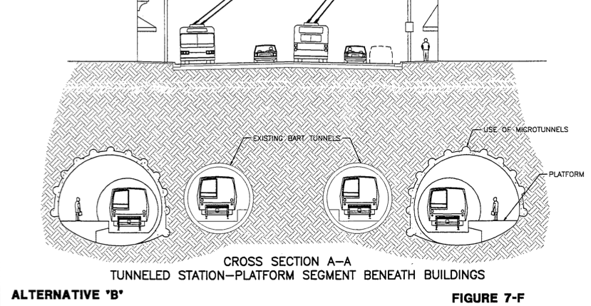
I still want my infill BART station at 30th though — La Lengua‘s easily worth half a billion of stimulus funds! PDFs on BART’s planning website (part B has all the construction porn). Bored tunnel, not cut-and-cover (like the rest of Mission was done), estimated 3.5 years of construction time, with just 11 months of traffic distruption, and a huge hole in the Safeway parking lot and Valencia/29th to get the dirt out and cement in. All for beautiful entrances at 29th and 30th, and a nice new building for El Patio! It could be our Carlo’s, where commuters are welcome…

SF Cityscape has an extensive bay-area transit map of the future.
And here’s the preferred dual tunnel that would allow express trains:
Now for that second Transbay Tube and offline tunnels for more stations. Simply shouldn’t take 30+ minutes to get to the airport…
Trackbacks
- So Wide These Streets Can Be « Burrito Justice
- Highway Revolt, Mission Freeways, “The Circumferential” « Burrito Justice
- De-Elevating The Mission Freeway « Burrito Justice
- BART To The Future « Burrito Justice
- And You Thought The S-Curve Was Scary? « Burrito Justice
- Damn The Bay « Burrito Justice
- Alternate Mission « Burrito Justice
- Reminder: 10 AM TODAY – Cesar Chavez Traffic Calming / Bike Lane SFMTA Hearing at City Hall « Mission Mission
- La Lengua and Bernalwood Co-Prosperity Treaty « Burrito Justice
- Homegrown “I BART SF” Shirt for Transit Fashionistas | Bernalwood
- A Vision of the Future to Make NIMBY Heads Explode | Bernalwood
- Timerider (SF Bay Interstate Edition) « Burrito Justice
- Big Hole in the Mission | Burrito Justice
- Bernalwood on Burrito Justice Radio: Recording Available for Your Listening Pleasure | Bernalwood
- D9 Candidate Josh Arce Proposes 30th Street BART Station and Housing Plan | Bernalwood


If I had my druthers, Muni would go farther East, maybe branching off from the J earlier, and the center of town would be able to connect to Balboa Park, as well as being a good bridge for the T to Balboa Park.
If you would like a more detailed map of the route the Mission Freeway would have followed, I just posted it to Flickr:
http://www.flickr.com/photos/walkingsf/3889615209/ (Mission District)
http://www.flickr.com/photos/walkingsf/3889616039/ (Bernal Heights)
DAMN. That is sobering. Thank you for taking the time to scan those.
I just subscribed to your RSS feed, not sure if I did it correctly though? Solid article by the way.
good to see there is still interest in the 30th street BART infill station. How can they get that proposal off the back burner? SF planning should have supported it.
I still think it would make more sense to do it a block further south, where Mission comes closest to San Jose. There is already a BART Emergency exit there, and the Shell station at the corner seems like it would offer more or less the perfect footprint for a Bart station…
Turning the Safeway into a mixed use residential / shopping / transit center would be more useful IMHO.
I of course also want it to connect to a N/S crosstown/midtown line. I think the Central Subway should:
– continue west to Divisidero
– go south under Divis (California, Geary, Turk, Haight) to Castro & 17th
– continue to Noe (Casto and 24th)
– intercept the 30th St BART station
– go under Bernal (with a Cortland and Ellsworth station)
– intercept the T-3rd (station would obviously be called Butchertown!)
– continue to the new Hunter’s Point development
If you *really* wanted to be ballsy, you’d make that the jumping off point for a new cross-bay tube to the Oakland Airport.
Maybe the whole thing could be a new BART line that would follow the same route but run under Geary or California instead of Lombard.
What’s a few billion between friends?
I’ve communicated twice with Director Radulovich’s office in an attempt to spur this back on track, but it appears that this project is buried for some time now.
Damn!
– Mike
If the 30th street BART extension would have gone through, it would have been done right about now.
That just makes me sad.
seems a bit close to 24th street, better to spend money elsewhere
The stretch between 24th St and Glen Park is one of the longer ones in the inner BART system – about 2 miles. A station between 30th and Randall would be about half way. BART has done outreach and nearly 2000 people in the neighborhood said they would use it if it were there. The problem apparently is the track grade which is uphill on that stretch of Mission. BART says it needs a certain length of track before and after a proposed 30th St station to make the trackbed level for the station platform. There are subway stations in NY though that are not perfectly level – like 34th St on the BDFM 6th Ave line. At the north end of the station the tracks and platform have an uphill grade.
Reblogged this on The Cynthia Project and commented:
I’m doing this from my phone; will add more later. (Sorry )