Mission History as Revealed By Creeks, Streams, Lakes and Lagoons
Allan over at Mission Mission and Telstar Logistics are investigating hidden ponds and creeks of the Mission. Thankfully the all-powerful David Rumsey has given us a gift of kick-ass digitized historic maps, and it gets even better as he has taken full advantage of Google Earth. Combined with the old Coast Survey maps of San Francisco, it makes for an excellent creek detector.
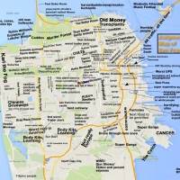
Last month I asked David to add my favorite map of the Mission to his Google Earth collection, the 1859 US Coast Survey Map of San Francisco (which actually shows the state of the city in 1857). While there are several other maps available in Google Earth (specifically the 1869 Coast Survey and the 1915 map), they all show the street grid we know and love today, or like the 1853 Coast Survey, don’t go further south than the Mission Dolores itself. The glorious 1859 map shows open fields, streams and lakes in the Mission we inhabit today.
Anyway, the 1859 map is sweet — click on this link and then open it up in Google Earth (or navigate there via the Gallery Layer). Here’s a closeup, with today’s streets as an overlay. Click to zoom.

Using the map, I traced the creek that ran near 18th St. Below are views looking west from Google Earth.

Old 18th St Creek, Castro to Dolores Park
It eventually fed into Mission Creek.

Old 18th St Creek, Dolores Park to Treat
Ever wonder why Treat is on that funny angle? Now you know – it ran along the edge of Mission Creek!
Here’s the .kml file if you want to download and use it as a layer in Google Earth. Brown is marsh on the 1859 map, and blue is the Mission Creek. The green area was “The Willows Pleasure Gardens” – possibly a beer garden! Click to zoom…

The Willows, 18th and Valencia
(There’s no date on this photo, but check out the flag — the middle row of stars looks shorter than the others, so I think this is from before there were 35 states (7×5) though how many I can’t quite tell. And the star field orientation is flipped — 7 rows, not 7 columns as was typical in that era. While it could be the 31 star flag for California’s entry, that was from 1851-1858 and was pretty asymmetric. 32 (1858-1859), 33 (1859-1861), or 34 (1861-1863) are more likely, but I digress…)
You can see that The Willows is in quite a low area, right where there was once a lake. Mission Dolores was build a few blocks from the edge of a lake that was gone by the time of the 1859 map. Laguna de los Dolores, amongst other names, seems to have filled itself in after the time the Mission was established — it went from about 15th to 20th, from Valencia to Howard (here’s a higher rez version of the map Telestar provide to Mission Mission). This soft ground accounted for the Hotel Valencia at 19th sinking in the 1906 quake.
Where was this picture taken? Since it looks like Mission Dolores is to the left of the flag, above the fence, I strongly suspect it was taken from the edge of the Union Race Course. If so, then here’s the point of view:

WHAT
Race courses in the Mission? Plural? Yup, two — the Union, roughly bounded by 19th to 23rd, and Capp to Harrison:

and the Pioneer Race Course, between 24th to 26th, and Mission to Bryant.

The all-knowing BobbyO helped me find this advertisement for the Pioneer Course from 1853.
What’s interesting is the relative position of these two racetracks — they seem to have affected the layout of the San Francisco-San Jose railway that cut through the Mission! Construction began in 1861 between downtown and the Mission in 1860 and the line started operating in 1863/1864.

.kml for the Pioneer and Union racetracks for you personal Google Earth viewing pleasure.
If you look at the 1869 Coast Survey map, you first see the railway. But in just 6 years after the completion of the SFJSRR, the city had already built around the tracks.

The train set a speed record:
The first full-sized steam locomotive produced in the state of California, an American 4-4-0, was built for the SF&SJRR by the Union Iron Works in San Francisco. It was appropriately named the “California”. Its inaugural run was August 30, 1865, during which it set a speed record of 67 mph (107 km/h).
Today, 144 years later, Caltrain’s top speed today is just 79 mph. That’s just sad.
Trackbacks
- Cesar Chavez Design Workshop Tonight; Precita Creek Past and Future « Burrito Justice
- Southbound and Upside Down = 22nd St Caltrain Revival « Burrito Justice
- 8-bit Mission « Burrito Justice
- Flash Flood « Burrito Justice
- 18th St Gulch, The Willows, Valencia St Hotel « Burrito Justice
- Physics Guy Rap | AboutPhysics.info
- Veo 218 Vara « Burrito Justice
- Treat Treatise « Burrito Justice
- The Willows & 18th St. Ravine in 3D and 1860s Mission Amusements « Burrito Justice
- Mission History as Revealed By Creeks, Streams, Lakes and Lagoons « Burrito Justice | ExploreSF
- -… ..- .-. .-. .. – — .— ..- … – .. -.-. . | Burrito Justice
- Dolores Street Bridge | Burrito Justice
- Mission Creek | jameskoehnsf's Blog


Excellent analysis of the maps – I thought I knew the 1859 map well, but you open up entire new avenues of history here….
dude that is an awesome post.
Thanks. I know I saw a poster for the Pioneer from the 1860s online somewhere but I’ll be damned if I can find it right now.
Another little interesting Pioneer tidbit I dug up — the 2nd California Cavalry mustered on the Pioneer grounds when they got called up for the Civil War in 1861.
And it looks like Treat Ave was named after a horse breeder. Wonder if that was his place jutting into the east side of Mission Creek on the 1859 map?
I find this kind of stuff endlessly fascinating. Thanks so much!
the poster?
http://content.cdlib.org/ark:/13030/tf958012b5/?&brand=oac
Thanks BobbyO, that’s the one! It was driving me nuts.
Now if you can help me figure out that damn song. :)
Perhaps you would enjoy the SF history bike tours:
http://shapingsf.ctyme.com/biketours.html
I thought I’d post a comment. Note I’m not attached either way, but after doing my own big of digging over on the other side of the Lagoon, I’ve got a lot of questions.
I happen to manage a building that, if the Lagoon did exist would have been sitting inside the boundaries of the claimed area.
I was also there when the 89 quake hit.
I’m definitely not against the idea of the lake, but if it was there, then there are some very major questions.
Since I am focussing more on the northeastern end of the lagoon I was able to use the 1853 map overlay with Google Earth. And this map is the one that does more than slightly challenge the whole notion of the Lagoon. Since it doesn’t include the entire Lagoon area, it may have been overlooked. But for me, it has topographical heights written for the Northeastern Lagoon area over to the Mission Creek.
When I started seeing heights ranging from 0-40 feet above sealevel, with zero being around the Mission Creek area. And note, in 1989, the exact area where the water expands the most around 17-18th on Shotwell, was where some of the worst damages took place, as well as down in front of where Rainbow Grocery intercsects with Division (13th) and Folsom.
But then I digress here. As the topo heads more towards what is supposed to be the center of the Lagoon the heights increase, and as I said, in some cases as much as 40 feet!
Any thoughts about this?
The only thing I could think of was that either the Ohlone were used as slave labor to fill in one hell of a huge area, drought conditions took away much of the water, or the Padres used the water up for agricultural purposes.
But I still harp back to those dramatic topo numbers! They don’t square with what much of the earlier writers were saying, but they don’t toss things out entirely as well either. Its a crying shame that the 1853 map doesn’t extend farther south as it would say much about the depths.
The other comment I’d like to make is that as a building manager on 16th street, the building I work on must be pumped around the clock to keep certain areas from filing up. I found watermarks in the basement during a retro 7 feet up on the walls, implying a rather devastating flood at some point in the past. But that still puts the water levels substantially below the current street level as it exists today.
If you are interested. I’ve put up images that I overlapped at http://www.energy-net.org/redstone/ that includes the 1853 overlays.
Of all the potential reasons for the Lagoon being gone, it would be very interesting to see if there is any historic reference to draughts from the 1770’s up through 1850.
I’d like to put the whole thing to rest.
Anybody investigated the whole Sausal movement in the area? There are several Sausal recovery movements around the bay area. A Sausal would be a low lying swamp/marsh area that would be surrounded by dense growth and Willows!
Anybody have a real photo image of the 3 dimensional model of the old Mission that is over at Mission Dolores?
Thanks for the work.
Roger, if you are interested in areas further south than on the 1853 map, the 1852 version may answer some questions. It doesn’t go any further west than in 1853, but extends all the way to Candlestick Point.
Thanks for the link Eric.
Since my post I found the following link that pretty much lays the issue of where the Lagoon was to rest for me. The older idea that the Lagoon came all the way down to 16th and Van Ness is likely wrong as shown.
Click to access Channel_Basin_Context_Info_pgs1-5.pdf
The Diorama over at Mission Dolores is a must see for anyone who wants to get a sense of just how beautiful this place was before we got here.
I’ve got a fantasy, to get a grant and do a mural at our building based on what the Mission looked like prior to the Spanish arrival.
I’m still looking for old pictures of the Mission but there are very few to be found (I’ve collected about a dozen so far, not to mention any official idea as to exactly where the Yeluma Ohlone village was located at here.
Roger et al.,
I am coauthor of Creek & Watershed Map of San Francisco, which is reproduced on the PDF from SFPUC which you have linked to. In specific, I am responsible for the representation of the lagoon in the location sometimes known as either Laguna Dolores or Laguna Manantial.
I was wrong!
I have since spent hundreds of hours and thousands of dollars tracking this story. I have retranslated the diaries of Anza, Font, and Palou; had surveys from disenos replotted, and have examined over 100 maps of the Mission prior to the 1870s. Numbers of historians geographers, and interested members of the Mission community have kindly shared their assets, information, and analysis. The deeper I have gotten into the research, the clearer I am that the representations of this water body in the historical literature resulted from a confusion by Anglo historians who misread a difficult passage in Font’s diary and confused Washerwoman’s Lagoon (in Cow Hollow) with the water body to which Anza gave the name De los Dolores – a name subsequently reapropriated by Palou to apply to the estuary clearly shown on all the Coast Survey charts east of Shotwell. This estuary did have a narrow arm meeting the creek running down a gully where 18th Street is now. Some evidence suggests that small dams may have been built in that gully between the gold rush and the 1870s, perhaps accounting for oral recollections of swimmable, even boatable water bodies upstream of the Willows. Neither mysterious vanishing acts nor astonishing amounts of Indian slave labor required.
I will be giving a free lecture at SFSU on October 6th giving a preliminary look at the information, and other lectures will follow. The Creek & Watershed Map of San Francisco will soon be updated, reprinted, and available from SFPUC.
Christopher Richard
Curator of Aquatic Biology,
Oakland Museum of California
I was always told the the creek came down twin peaks along 17th street, not 18th.
The area around 18th, Folsom and Shotwell is definitely bottom land. It flooded when el nino broke the drought in the mid nineties. Once flooded you could see the outline of what was once there as it made its way toward 16 and Harrison down further to what is now best buy (then i think it was a wrecking yard) and over through the old rail yards to the houseboats before dumping into the bay.
In the early aughts Shotwell was dug up at 17th and huge storm drains were installed. So somethings going on under there.
ah… the GIS data that the PUC charrette map for Channel Basin came from me and Oakland Museums Creek map. My feeling about the lakes in the mission is there are areas that would have naturally ponded after heavy rains but they would be quite shallow and the water would have quickly infiltrated or evaporated, these definitely would be only once every few years. Definitely there was quite a bit of filling in the area, some of the dunes and hillocks showing in the Gardens photo would have been “dozed” or pushed around to level the mission mostly by horse pulled blades, wagons and shovels, typically immigrant labor probably in the 1880s (probably not indians as speculated above) just as was done south of market in the 1860s-1870s, filling in the depression where the “lake” was as well as the slight ravine where the mission creek was (along 18th).
Along with the spectacular loss of the Valencia hotel in the 1906 quake which was in the historical creek bed, shotwell street also lost 3-4 houses in the 1989 quake which were immediately re-built. Our current version of “lakes in the mission” (see “turn on the pumps!”) is the same issue, namely settlement of the area of the mission landing on the creek at the head end of the slough around 17th and shotwell. The landing was accessible by boat for most tide levels and is now at 10′ city datum (about 21′ above low tide) there would have been maybe 15-25′ of fill in much of that area.
If you’d like the GIS files that were used for the LID charrette (Channel Basin pdf referenced above) let me know. I also have tons more historical maps.
hmm…
I would be interested in more maps, but I imagine they are probably all later than earlier. The 1898 map that shows the original lagoon is amazing. The 1851-3 topo maps really started to make me wonder exactly what was happening. Then I saw a picture around 1860 looking towards Valencia shot from what is now Duboce park and saw all of the sand dunes just off of Centre (16th).
Having seen the recent first part on Saving the Bay (KQED) they mentioned a group that was doing all kinds of advanced mapping of pre-modern SF. The show included a high tech animated short of the original Mission Bay as well. That drove me nuts, as I missed who the group was that was doing the work.
As the manager of the old Labor Temple on 16th street this issue is of major importance to me in terms of long term impacts to my building. We also have a substantial number of murals documenting the labor history of building and want to add more murals as I mentioned above.
An interesting note. The 3 buildings that were damaged in the 1989 quake were quickly red tagged by the city and then put under 24 hour police guard as the property owners had no quake insurance. They sat damaged until Thanksgiving eve when the police took down their guard for the holiday eve. Within hours all three of the buildings were torched and burned to the ground, the claim that a homeless person got into them… Yeah right…:)
Also, I still have very serious concerns about exactly what the area looks like. From the 1851 painting looking across the Mission from the old buildings, showing a flat grassy area, I’ve seen materials that suggested that the Mission was doing major animal husbandry near the mission… In the thousands of animals.
When I heard about the Willows area on Valencia that especially caught my attention as there is a “Sausal” movement here in the bay area that has also done work at restoring similar areas like the Mission over in the East Bay. The Sausal or swampy area that usually included a lot of Willows and berry thickets represented areas where a lot of wildlife congregated for water and food. Thus the existance of the Yeluma village.
Anybody heard about or have a map of the village’s exact location?
PS…
I’d like to look into the idea that Centre (16th) or Dolores were very likely the first streets ever in SF if not some of the oldest in California.
Greg, funny on those GIS sets — I was just doing some poor-man’s-GIS in Google Earth tracing out the elevation contours on the 1853 and 1859 maps. You can clearly see the gully — a 40+ ft drop in a block.
And here’s an overlay of the Laguna de Manatial map. There’s clearly something going on — the temporary/seasonal shallow lake makes a lot of sense, especially if what would become Mission St was at all raised. (The contours are kind of whacked on the SE side of the above images so it’s hard to tell how high that area is by the lagoon.)
Another thought — did the Spanish or Ohlone ever make artificial ponds for stocking fish?
Anyway, I’ve been gathering material on The Willows and will post the GEarth layers when I get a chance. Greg and Roger, I’d be happy to add your material if you’d like.
I’m not sure how to find contact info on the blog…
you can contact me directly at:
greg.braswell (at) sfpdw.org
oh first streets in calif would probably have to be in San Diego from the landing to the mission and the “El camino Real” was the first “highway” (ha-ha) but interesting idea, definitely it was the first “street” in sf.
Re: Ohlone and/or Missions having fish ponds, very unlikely, I dont think there’s any other calif. tribes or missions that did that and if done its usually in some tidal flat.
My feeling about the lake is that the drawing is off, I think that’s a projection of historical antecdote overlaied on the street network. I’d say the wet areas around woodward gardens and close to 18th that are marked as “swampy” in the Coastal Survey map probably turned into season wetlands during wet years. I’ve tried to make sense of these too and it just doesnt fit, your picture of the willows substantiates that somewhat. I doubt the padres moved much earth to do farming.
dont forget the coast survey maps start to lose positional accuracy as they move inland, to accurately refernce you have to rubbersheet more based on known locations. Maps with the street grid tend to be fairly easy to reference but always be a little skeptical.
most missions had cattle (lots of cattle, into the thousands) but my understanding of the SF mission delores was that it was actually 1 of the poorer missions (san jose being 1 of the richest). My understanding is that part of the problem was the lack of good “indentured servents”, aka indians, because SF indigeneous population was relatively low compared to other mission sites. Its been a lot time since I’ve read on this though and I’ve had more then my fair share of zeightgeist so dont quote me on any of this…
The map that shows the streets is from Zoeth Eldridge’s The Beginnings of San Francisco, from 1912, and is a reconstruction from fairly flimsy evidence: He says “The only map I have seen which shows the Laguna de los Dolores is that of La Perouse”, and the La Perouse map is extremely distorted. It probably establishes that there *was* a lake, but certainly not its exact location.
Some more detail from John Hittell’s 1878 “A History of the City of San Francisco” – Perouse never actually landed here.
We learn from the writings of Friar Palou the founder of our Mission that the site as then selected and afterwards occupied was near a lagoon the situation and size of which he did not accurately describe. It had disappeared before 1819 the earliest date to which witnesses now living can carry back their distinct recollection.
A map on a scale of two miles to an inch of the end of our peninsula in the report of La Perouse’s voyage in 1786 copied probably from some Spanish chart (his expedition did not visit any Californian port save Monterey) shows a lagoon with an area of about three hundred acres in the neighborhood of Mission Cove but the lines are so incorrect that it is impossible to ascertain from the map whether this water was north south or east of the Mission or how far from it. It was probably a hundred yards or so to the north eastward where the ground is low. A slight ridge thrown across the little valley there would make a lagoon again…
…The oldest residents know nothing of any tradition of a lake near the Mission and we have no explanation for its disappearance.
This is now my favorite history — he interviewed Carmen Bernal.
Zoeth also mentions Carmen in her lagoon section.
And I particularly like how Zoeth takes on Bancroft on page 328. “Bancroft is mistaken.” SNAP!
Johnny0’s Manantial map, and others that I’ve seen, call the 18th Street creek Dolores Creek.
Recent Presidio maps posted near the reclaimed Chrissy Field Lagoon identify the Yelamu village as being located near Belcher Street, on a pond of a second tributary to Mission creek that went down 15th & 14th from Duboce Park through the Armory (placed there for their horses to drink from that creek).
That second creek flowed from near the Panhandle through many dunes (sometimes seeping invisibly) to the area near the village. I seem to recall having found a photo at the library SF history room showing a pond at 14th & Market with Market Street streetcars going across it on a bridge. Some call that creek Sans Souci Creek named after the Lower Haight which was called Sans Souci Valley in at least one photo I’ve seen from the 1860s. The name is probably connected to a property labeled ‘Sans Souci’ along Fell west of Divisadero, according to the 1861 Langley map.
Greg, thanks for letting me know about this thread!
I’ve been trying for weeks to take that 1857/1859 Coast Survey map and overlay current streets on Sans Souci Valley, but I have no GIS software, no training and only just bought photoshop, so I’m at a severe disadvantage. (I hardly understood the jargon in this post, and my old G4 laptop barely can run Google Earth, even if I knew how to use it!) If someone wants to help me develop old and new combo maps of the Wiggle (current-day bike route following old Sans Souci Valley) for a public art project, please get in touch with me using thinkwalks at earthlink dot net.
I can try to get funding–at least that is something I’m good at. I fundraised and produced Mona Caron’s SF historic and transportation murals for years.
I think the first SF street was the trail the Yelamu used to get from their seasonal village in the area near the Golden Gate to the seasonal village near the Mission. This later acted as an extension of the Camino Real, which ended at the Mission Dolores.
Here is a bit more of what I’ve got and why this is just so all over the place…
I’m not good at Spanish, but I’ve got an 1781 map apparently done by Jose de Canazares that doesn’t show any lagoon at all. Then I have the La Parouse 1798 map as linked above that clearly shows the Laguna on it. The La Parouse map looks a lot like an 1852 map I have.
The 1781 map was clearly of very poor quality. I’ve also got an 184x map that shows the Laguna over by 18th and Treat! Another 184x map geological map I’ve got is very intriguing, but very hard to figure out as it shows a whole series of water bodies.
Then of course there is the new Channel Basin map done by the city I mentioned above by link.
The 1853 Map done by William P Blake is very interesting as it represents one of the more accurate investigations. It shows the sand dunes just to the north of the mission in detail. It is almost identical to the modern map showing the “Alluvial” soil around the core Mission area.
Just to vouch for just how far off things can be, this past summer I nearly made a whopper of a mistake, when I thought I’d discovered what would have been the oldest Labor building in California located at 316 14th Street. Due to major shifts in city maps I was fortunate to catch my error before taking it before the SF Labor Council. Sadly, the first SF Labor Temple in the city built after the 06 earthquake was torn down in 1951 and was located exactly where the current Arco Gas Station is situated at on the corner of 14th and Mission.
I also have a huge number of jpeg maps/images… Most were from Bancroft.
Thanks for the detail about the streets. The Yelamu trail would make a lot of sense.
Now, I’m all confused about the idea of locating the Yelamu village way over by Belcher and Market St. I guess this is caused by the way we laid out the city vs. how it would have looked prior. That would place their village around the otherside of a hill between the Mission.
I was thinking the village would have been located near the Dolores Lagoon and closer down to where there was more water. The idea that there was another body of water up there appears to contradict the 1853 Blake map showing the area up there being more of a sand dune area.
I trail between the two villages likely mirrors the present day bike trail most bicycle folks use to get from the Mission over to the Haight without having to do any major hills.
I have one correction to make on the Perouse map. I have an original copy from the Bancroft library, rather than the link above, and it is written right on the map as dating to 1798. If you blow up the for sale version linked above and look very closely, you should also see the 1798 date on the bottom in the middle.
This is getting interesting. I just took a peek at Johnny’s link to Zoeth’s writing and there are more questions.
I happen to have pictures of all the gravestones over at Mission Dolores and looked up Jose Bernal’s Gravestone…
Unfortunately, the gravestone says Jose’s complete name is Jose Jesus Bernal, and I can’t read the dates. But its one of the larger graves there. Would be interesting to make sure Jose Cornelio Bernal is a descendant of Jose Jesus or that Carmen is part of the stone I didn’t get a pic of!?
I just took a peek at the Valencia family grave, and it looks like many of the gravestones still in the graveyard may be of a later period as I looked for Candelario Valencia’s grave but only found stones from his kids dating around the 1850’s. Candelario was the person Valencia street was named after, and was an Anza soldier as well as living near the Mission. Wouldn’t it be interesting to find out where his house was!
One of the more bizarre moments for me when I did my photo collection of the graveyard, the day before I went over to take pictures I found an 1860 photo of the graveyard. I just barely got there after they closed. So I went around the corner onto the Alley and to my surprise was looking at the exact same view nearly 150 years later, with the same stones, minus the protective fence. I went in primarily to get images of the diorama and the Ohlone home they put up right in the middle of the graveyard.
Unfortunately the map of Candelario Valencia’s land claim doesn’t say exactly where the house was, but I’m guessing the Valencia house was probably the building on the east side of Dolores at the corner of 17th, which was in the middle of the large Valencia lot on Dolores. (http://www.pobox.com/~enf/pix/candelario.jpg) But there were also several buildings in the Valencia plot on the southeast corner of 16th and Dolores, so it might have been one of those.
My posting from a while ago about the Valencia and Guerrero lands: http://enf.livejournal.com/127675.html
If you haven’t come across it before, you might find my graphic of the trans-mission railroad’s path interesting:
http://www.xrg.us/missionrailroad/
I also just noticed that Google has added lot boundaries to their maps, making the path clear, even where it passes under the 280/101 interchange. Just southeast of there, you also see similar remnants of the railroad that tunneled under Potrero Hill.
A couple more comments about the Perouse map and the others I mentioned. As everyone who has lived here for more than a decade or so, those sand dunes weren’t there for nothing. The bay area can experience levels of rainfall that vary quite dramatically. And since we are talking about a very shallow body of water, it could very well be that the Perouse map was done just after a wet period. When I rotate that map it looks similar to the manatial map if you fill in the two bodies.
It would be interesting to note if the Padres kept track of weather patterns. Or maybe somebody has done a detailed tracking of tree rings to see if there were any dry years that may have resulted in drying up the lagoon.
Too Bad Victor Miller isn’t still around. He’d probably have a huge web page up on the North Mission by now with all kinds of maps, down to the point of who lived where and when… :)
Johny, if you want some more of the maps I mentioned email me… I will send them along. To really get detailed, it would be nice to have a chronological set of maps organized from the earliest out there. The earliest detailed map I have of the bay is 1772… Very strange looking map, but not as bizarre as the 1661 or 1699 California maps…
@Eric, thanks for the pointer to the Valencia and Guerrero land claim. The small Bernal claim was just to the east of the Mission.
@Roger, Jose Jesus was Jose Cornelius and Carmen’s son. He actually died 6 years before his mother did.
Juan Francisco Bernal + Maria Petronia = José Cornelio Bernal (1796-1842)
José Cornelio Bernal + Maria Carmen Sibrian (1804-1876) = José de Jesus Bernal (1829-1870)
José de Jesus Bernal + Geronima Rufino = José Cornelio Bernal II (1857-1926)
José Cornelio Bernal II + Julia Valencia (d. 1925?) = Cornelius and Alfred Bernal
@Craig — dude, you are my map hero! I am ridiculously jealous of your train map. Didn’t realize Google had the properly lines though.
I really want to line up the houses behind on those two shots of the Dolores Street trestle bridge but I think I’d need a balloon or a ladder.
Very nice job on that map Eric!
Any chance of it being related to Jerry Brown’s family? They built the Victoria theater after the quake as a local Burlesque operation…
Have any of you folks seen the land grant maps recently over at oac??? I spent a couple of evenings in July downloading many of them… Just took a peek at what I had for the first time.
Anybody know what the Sheppards property was? One of the 1850 maps that shows the mission split in two, with what looks to be Mission Street. On the East side of Mission, the only thing marked in is the Union Race track, and on the west side, two blocks wide and nearly 10 blocks long is tract of land labeled Sheppards… It looks like it covers the Willows area.
@roger, you should post those maps and photos on Flickr.
@Joel, funny thing, I had just traced the path from the Mission to the Presidio from the 1853, 1859 and 1869 Coast Survey maps. I had to guess a little as the 1859 map stops at where Divisidero is, but Lone Mountain and Anza Vista pretty much narrow down the possibilities. Here’s the Google Earth kml.
A couple of links for anyone who wants to look at historic links to the Mission:
Calisphere: Mission Dolores
http://www.calisphere.universityofcalifornia.edu/browse/keyword/%22Mission+Dolores%22+%22Mission+San+Francisco%22?keyword-join=or
October 1850 drawing overlooking the mission
http://content.cdlib.org/ark:/13030/kt9f59p0fz/?query=%2522Mission%2520Dolores%2522%2520%2522Mission%2520San%2520Francisco%2522&query-join=or&brand=calisphere
2007 Historic review of Mission Dolores
Click to access MD_Context_Statement.pdf
The Mission Dolores Galvan controversy
http://www.sfweekly.com/2007-11-21/news/reburying-indian-skeletal-remains-bay-area-construction-meet-andrew-galvan/full
The Presidio’s Levantar Project:
http://www.presidio.gov/history/archaeology/
Lastly, Here is a quote as to the size of the Mission from J Hutchings in 1862…
in 1825, only six years before, that of Dolores, alone, is said to have had seventy-six thousand head of cattle, nine hundred and fifty tame horses, two thousand breeding mares, eighty-four stud of choice breed, eight hundred and twenty mules, seventy nine thousand sheep, two thousand hogs, and four hundred and fifty-six yoke of working oxen; and raised eighteen thousand bushels of wheat and barley. Besides, in 1802, according to Baron Humboldt, there were of males, in this Mission, four hundred and thirty-three; of females, three hundred and eighty-one; total, eight hundred and fourteen.
The link to the above is here:
http://www.yosemite.ca.us/library/scenes_of_wonder_and_curiosity/san_francisco.html
Most of the maps I’ve gotten are from sources like bancroft or other online services… Reposting them publicly isn’t gonna happen because of the major research project I did around the SF Labor Temple. They are very strict about controlling their materials and I don’t want to jeopardize future access to their physical library… If you’ve read Grey Brechin’s Imperial SF, you will only see a handful of images as Bancroft charges huge fees for using their materials. To get a single image out of their library can cost $50 bucks just for private use, and much more if you want to publish it anywhere including online.
The Calisphere link put up by Roger on Saturday had a trove. I found two things that stunned me, the second one not being in his search results, but in a search for “Potrero Nuevo”.
1st. Shows a meticulously surveyed area around the Mission Dolores in the fourth and fifth items in the top row at the Calisphere link, including water ditches and the old sand hill to the north. The big squares are marked off in varas (about 33 inches in length), meaning the top of the map is at Clinton Park.
2nd. Shows an 1862 photograph taken from about the same spot and at about the same time as the famous lithograph of Mission Creek and the Cotton Mills. http://sunsite.berkeley.edu/FindingAids/dynaweb/calher/graves/figures/I0030457A.jpg
The famous 1860 litho is at the link below
http://content.cdlib.org/ark:/13030/tf7g50119h/?query=1860,%20from%20the%20Potrero%20Neuevo%20&brand=calisphere
If you look closely, you can even see a train in this lithograph!
well, ok, the discussion of the mission riches shows it depends on when you look, from Hutchins description definitly doing well at 1 point. Richard Henry Dana’s description from 1835 or so was even more pessimistic about the vitality of the Mission Dolores then Forbes referenced by Hutchins if I remember correctly.
Joel, you’re link to the 1860 litho along with the Hutchins description is exactly what I was looking for, the boat landing at the woolen mills.
The maps of “lakes in the mission district” I’m not thinking were trying to describe the Mission Creek and tidal areas based on the shape of the drawings and the shape of the creek.
Oops, yes. Woolen Mills, not Cotton Mills.
How Real is this image?
Here’s a link to a description and image of bars on 16th street sometime between the 1850’s and 60’s…
http://drinkmemag.com/2009/06/
Oh, and its one of the nicest pictures I’ve seen…
Beautiful picture, but it’s not Center/16th — it’s Portsmouth Square:
I’m sure there were plenty of bars in MIssion District but probably not too many in 1851. HOWEVER…Mission Dolores historical context statement linked to above has pretty cool picture of the mission dolores turned into a saloon with a date of 1865 (pg 19, fig 7,7a)
lots of links above, I’ll repost:
Click to access MD_Context_Statement.pdf
The link below is of especial interest to me.
If you have the time, note that it is one of those special maps where you can do a detailed closeup look. And this is one map you don’t want to just take a glance at.
http://content.cdlib.org/ark:/13030/hb4s20052d/?query=san%20francisco&brand=calisphere
Its dated from 1857 and is apparently part of the San Miguel land dispute. What is of interest is how the El Camino Real is drawn into the map as well as being a rather crude topographical view of the city.
One of the more interesting close up is of the Arroyo de los Yolais. Initially, until I blew that section of the map up, I thought I was looking at the original Mission. Nope.
But if you follow the Camino Real all the way to the end, there is the “Es de Dolores”, with a tiny little square just below the letters.
I was taken off guard by the Laguna Seca (dry lagoon) on this drawing.
I’m assuming that this was made far earlier than 1857, but was used as evidence during the land claims.
As part of the whole theft of lands, that plays a root cause for the filling in the SF Bay, the below 1873 and 1874 Maps shows all of the lands that were part of the state’s tidelands selloff that was used to take over large quantities of land.
The first link shows the tidelands selloff for the whole bay areas, the 2nd is for SF alone.
http://www.davidrumsey.com/luna/servlet/detail/RUMSEY~8~1~3329~360047:Map-exhibiting-the-salt-marsh,-tide
http://www.davidrumsey.com/luna/servlet/detail/RUMSEY~8~1~3329~360047:Map-exhibiting-the-salt-marsh,-tide
Wasn’t this tidelands law how Henry Miller ended up taking over most of the Central Valley? I’ve got an old map somewhere of all of his holdings.
This whole land transfer issue from latino to white needs the same historic mapping evolution done for it as well.
Re: “Its dated from 1857 and is apparently part of the San Miguel land dispute” It probably actually dates back to 1845, when Noe originally petitioned to California governor Pio Pico for the San Miguel Rancho. The original grant request –as shown on Noe
s “disueño”– went all the way west to the ocean; but the grant as granted extended west only to about Junipero Serra today.
A disueño was a requirement in any petition on the part of a Spaniard to receive a land grant. It would typically be a hand-drawn “map” of the requested land, with landmarks included (lakes, trails, trees, scrub brush, etc), and marked off in ropes or chains thrown down from a horse to measure it off. Very different from a contemporary survey.
re: lakes in the mission…
was at anchor brewery monday (tour day of various processing plants, started at sewage treatment plant and worked our way back to the source). They have collection of posters of old SF panoramas I hadn’t seen before including 1 of mission district circa 1870 which included a lake they identify as “Lake Dolores”.
http://www.anchorbrewing.com/beers/2002poster.htm
re: central valley, yes the general idea was you could get land free or nearly free if you could row a boat across it as “land reclamation”. The story goes they put the boat on wheels and rowed it across vast tracts.
Nice picture…
For a bit, I thought there was something wrong with the lake’s placement, so as part of my own mapping project work, done a bunch this week, I went to the below link to look at the gov’s birdeye images of the city, which are rather spectacular if you’ve never seen them before.
http://memory.loc.gov/cgi-bin/query/S?ammem/gmd:@FILREQ(@OR(@field(TITLE+@od1(San+Francisco+))+@field(ALTTITLE+@od1(San+Francisco+)))+@FIELD(COLLID+pmmap))
If the above search link works you should see a list of 10 birdeye high resolution images the city from 1846 to 1887.
I took a look at the 1868 view and my goodness does it have the lake and all of the buildings and the mission in full detail if you zoom down into the image. If you have a jp2 reader like irfanview you can download the large 31 meg image and then start pulling images out of the larger map…
So in the 1857 San Miguel dispute map, it looks like we’re hovering above the Mission Creek (unseen) and looking to the west towards the Pacific (oceano, playa and arenal on the top). The Lomerias are Twin Peaks, Laguna Honda is obvious, and the “chamisal” seems to be brushlands?
Some interesting detail along El Camino Real:
-I suspect the square by Precita Creek is the Bernal house.
– Above the “Es. de Dolores” you see what could be the 18th St. gulley.
– I don’t know what “Cañataies” means but I wouldn’t be surprised if it had something to do with sand dunes.
Anyway, the road between the Mission and the Presidio would have gone right by the laguna seca on that map. Looking at the contours of the 1853 map, there are two depressions where a lake could easily have been, one centered at Scott and Oak, and the other at Herman and Belcher. Here’s a map I made highlighting the low areas on top of the 1859 Coast Survey map.
I bet the laguna seca once was the lake described by Vallejo and Anza via Zoeth:
Vallejo: “The lake of Dolores was located and could be seen to the right of the road coming from the presidio to the mission between two hills” … The editor of the memoir identifies the spot as the San Souci valley immediately behind the hill on which the Protestant Orphan Asylum now stands.
And Anza wrote on March 28th that at a little more than half a league to the southeast of Laguna Pequena (Washerwoman’s Lagoon) there was a rather large laguna that appeared to be permanent on the margin of which garden stuff could be raised.
To me, “Laguna Vallejo” seems to be the most likely candidate for our mysterious Laguna Dolores.
There’s one more possible piece of evidence I’ve been mulling over. This one may be a bit of a stretch, but if you look at the shape of the Laguna Manantial from the Zoeth book, as I do here, it bears a striking similarity to Laguna Vallejo that I traced out.
Also, if you compare the creek at the bottom of Laguna Manantial it to the 1859 topology and contour lines, it matches up to a low point where an exit creek — Souci Creek — would go from Laguna Vallejo. Unfortunately I don’t see any reference to where Zoeth got the map from.
So:
– The old topology of the 18th St ravine and around the Willows doesn’t seem to allow for a lake of any size, never mind one the shape of Zoeth’s Laguna Manantial.
– “Laguna Vallejo” was a lake on the road between the Mission and the Presido in the 1770s but had dried up by the early 1800s. (Remember that Maria Carmen Sibrian Bernal, who moved from Monterey in 1821, had no recollection of a laguna by the Mission.)
– Towards the end of the 1800s, people got it and Mission Creek (and possibly a seasonal pond at The Willows) confused.
When I have more time I will collect all of this into one post.
I appreciate your comments and perspective on the San Miguel dispute map. It would certainly be very interesting to know more details about that map and where it came from.
Upon looking at the 1868 birdseye view mentioned above that has some of the best drawings of Mission Creek and the hydrology flowing down from above 18th street.
I’m not sure I’m ready to call the Dolores Lagoon or Manatial closed. Your map does look close. However, the more I step back and look at the entire Mission as a reservoir for the runoff from Twin Peaks, I have to say that the most important issue for me is the one that will take a whole lot more research.
Its very likely that the Padre’s didn’t keep very good historic records at Mission Dolores and especially rainfall levels.
California, especially much of the central valley was known to have major flooding including one that destroyed early Sacramento. I think it is perfectly sensible to step back and see the Mission district say 10,000 or 100,000 years ago in a very different light than today and do so in with the idea that the entire Mission may have been a lake itself at some point.
Would it be possible to evaluate events in the last thousand years or so that might indicate the potential of a much larger amount of water in the Mission?
Yes, of course there is. It would require going to somebody who has done a bit of work on the Redwood tree rings here in the bay area.
We know the city has burned down several times, yet mostly, all we ever hear about is the 1906 fire not the other ones.
The 1868 map shows a substantial amount of water. Was that a raining year? Or moderate.
The primary issue for me goes to the technical and a map, I’m not gonna remember which one I looked at in the last two weeks, but it showed soil types and the entire area of the north mission as we know it today was charted as having alluvial soil. That tells me one an only one thing, that it was deposited here by flowing water from flood plains, rivers etc.
I’m probably pretty settled that Mrs. Bernal didn’t have any memory of water. Are there any Bernal family members still alive?
We know that in its later years that Mission Dolores was rather poor. But its quite clear to me that this was caused by overuse. The sheer number of animals the Mission Dolores had (160,000 cattle, sheep and hogs) as mentioned previously, its not beyond question that there was a very large body of water to service such a demand.
After the number of maps I’ve looked at including a highly detailed railroad map of 1851 that shows no water whatsoever around the Mission, yet the highly detailed, 1868 view that includes all the water, I’m very skeptical of older maps and what they do or don’t have on them.
At this point, I could imagine the entire Mission being under water from a 1,000 year or 50,000 year storm…
I’ve pretty much wiped out my old major sources of mapping downloads after yesterday’s work from the Library of Congress maps. Its possible to do a far broader search from the 10 LOC maps I mentioned above. I was able to find several 1544 maps of california, and of course there’s the supposed 1418 Ming dynasty map that shows california as an island. I’m still very suspicious of that map due to its real creation date of be much later and during the period when literally all European maps were also making Califas out to be an island.
I’ve got enough material to fill a huge book, but am not the publishing type in that format. I figure that I will do a slideshow of maps that go back thousands of years hystorically (spelled purposely). The idea of drilling down to the Mission through hundreds of maps gone back so far has been very fun to do. I’ve always held out hope that there might be a few more unknown maps out there that would help build up more historic information about the neighborhood, especially on the kind of level seen with the birdeye maps, after 1880 up until the quake. The only other alternative are photos of the north mission and at this point I’m focussing on 16th (center) and Howard around Adair.
If I had a couple spare thousand hours and the money to go along with it, I’d print up many of these maps and put them in a room and then get feedback…
Anybody know of any other online arcane map sources?
re: number of cattle at the Mission, it seems to me that the inventory would include the Asistencia’s and
http://www.californiamissions.com/morehistory/dolores.html
We rode about one league to the east [from the Presidio], one to the east-southeast, and one to the southeast, going over hills covered with bushes, and over valleys of good land. We thus came upon two lagoons and several springs of good water, meanwhile encountering much grass, fennel and other good herbs. When we arrived at a lovely creek, which because it was the Friday of Sorrows [the Friday before Palm Sunday], we called the [creek] Arroyo de los Dolores … On the banks of the Arroyo … we discovered many fragrant chamomiles and other herbs, and many wild violets. Near the streamlet the lieutenant planted a little corn and some garbanzos in order to try out the soil, which to us appeared good.[10]
http://en.wikipedia.org/wiki/Mission_San_Francisco_de_As%C3%ADs
As part of my growing investigation on the Mission, as mentioned above, I started looking into the issue of droughts. Here’s a link to a fairly technical overview of water issues over the last 10,000 years in California.
http://escholarship.org/uc/item/61j1j0tw
It is rather sobering in what it says. For example tree ring and bio-sampling of of the SF-Bay estuary indicates that there two massive drought periods 900-1150 and 1300-145 in the past.
Furthermore, I messed up and didn’t keep the link to another article I read yesterday that told of how an extreme drought actually changed the entire history of California as we know it today in the early 1840’s. It was that drought that led to Russia’s abandonment of expansion here. Sutter’s Mill failed to pay its lease for three years during that period, which consisted of agricultural goods, due to their Russian landlords!
There was also another drought in the 1870’s that very likely played a key role in drying up Mission Creek.
The above report listed all kinds of studies that were used to compile its data. It also said that the last 100 years have been very stable compared to earlier periods, but clearly warns that the huge growth in population and growing climate instability are ahead. We’ve already heard elsewhere in the media that there is a growing trend of warmer winters that will effect Sierra snowpack very likely accompanies by more vicious storms, similar to the leftover typhoon that hit the bay area in October.
The report also went onto to mention that there were also super floods as well. So I think its pretty clear that the Mission’s topology represents a place where standing water took place in cycles.
Originally being from South Dakota, and living right next to the Missouri River floodplain, there is an old story that fits exactly as to what might point is here…
When Europeans first came to the area, they were especially attracted to the incredibly rich soil right down in what is now known as the Missouri’s floodplain. So they built their town on the floodplain, because the Missouri, which at the time was over on the other side of the floodplain nearly 12 miles away.
In 1889 there was a massive storm that winter, followed by the flood that filled the entire 13 mile wide floodplain, washing the town away and killing those who weren’t able to escape to higher ground. That’s when they realized why the local Yankton Dakota people had built their communities up on the edge of the plain…
Well, let’s just say that the first nations of indigenous people very likely learned from hard lessons where to live or not. Thus, the location of the Yeluma villages here were located to protect them from flooding but not so far away from the water’s edge.
One last comment from initial perceptions. On going through so many maps, so far to me, the quality of the mapping skills that took place has become of interest to me. It was clear, that the Spanish-Mexican culture was lagging far behind compared to the Russian and French Mapping skills, with the US and British not far behind. By the 1850’s the US, with Freemont, were able to create very high quality maps.
Lastly, if you are into maps, the below link is to what appears to be the very first map currently known that shows California. There is still a lot of misinformation out there about this, as I’ve found references to claims that an 1562 map was the first to show California.
The below link is to the Library of Congress. To see this fantastic color map from 1544, you will need to first click on the thumbnail from the below link. This will then give you 12 more thumbnails. Image #4 is one of the two images you will want to look at. The other image, a must see is image #13, which requires that you go to the bottom of the page and click on the “Next Group” option. All of these images have special magnifiers to look closely at the amazing detail in the maps.
You can download the images which are in jpeg2000 format, which means you need a special reader to see the image.
http://memory.loc.gov/cgi-bin/query/h?ammem/gmd:@field(NUMBER+@band(g3200m+gct00001))
And here’s a link to a brief history of how the name California came to be used.
http://www.scvhistory.com/scvhistory/signal/reynolds/part06.html
Here’s a link to another amazing map. In this case it is the 1798 west coast map done by George Vancouver. This is a Rumsey map. The real diamond on the map is located in the lower left corner inset, which is a detailed map of San Francisco.
It doesn’t look like much until you start zooming into it with Rumsey’s zooming option. You will then see what appears to be another version of the Lagoon. The location isn’t that great, however, Vancouver’s map of the city is clearly one of the best I’ve seen so early.
http://www.davidrumsey.com/detail?id=1-1-2280-200023&name=The+Coast+of+N.W.+America.
This Wednesday (12/09/09 7pm) I am giving a talk on the creeks of S.F. at the Axis Cafe. I have a lot of material on Laguna Dolores. If you are interested, please come and join in the discussion. Bring your maps and research — we’ll share.
Kindly let us know should you choose to do such a thing encore?
Thanks Christopher, I will try to make that.
Christopher, sorry I wasn’t able to make your lecture. But please do let me know the next time you’re speaking.
The event was very well done and standing room only, which meant people had to leave.
I was sitting next to an older guy who was there for the Presidio springs.
I didn’t quite catch her name but as I told the geologist who was there, I’m gonna be a bit more careful because I’m responsible for a large 50,000 ft building with the water table sitting about 7 or 8 feet below the ground floor and evidence that the table may have come up nearly to the surface.
The 1853 maps showed two things to me.
1. That the soil type on 16th and Howard is Alluvial.
2. That the our building is about 20 feet above the lowest point in the Mission.
Anyone can clearly see the drop between our building and where the original Creek runs across Center (16th Street) 3 short blocks away. The clear evidence I found of water damage that goes up almost to the ground floor at our building is the primary concern I have about what constitutes any possible location of the lagoon or swamp in the past. Just as the 1853 geological survey that stated that the entire area was alluvial soil.
So rather than merely speculate for mere intellectual purposes I was wanting to find out what kind of investigation my help determine whether or not there was some kind of past water body under the building. As I stated I inherited the management from an old timer who had been in my position for 20 years, going back prior to the arrival of the BART. Who claimed that there was a creek running across the building’s property from north to south. And of course, that is where we have traditionally had to pump water along this line 24 hours a day.
I gave the wrong response about the maps at the event. It is my belief that its the 1898 Vancouver map of the city that was used to create the map that is used at the monument at Camp and Albion. When blowing up the Vancouver map, it has almost exactly the same lagoon shape.
The Manatial map is referenced in the report financed by the city of SF that was done by two consultant/scientists for the historic/cultural status of the Mission in 2003. Its late, but I saw the report just a day or two before last Tuesday’s event out on 8th street.
I want to thank everyone who came to the Ask a Scientist, and particularly all you who joined in on the discussion. I had a great time, and hope that I shed some light on the mysteries.
If Roger is wondering who the geologist was, it was Janet Sowers, who has been the first author of most of our creek maps and a great professional. She is with Wm. Lettis/Fugro in Walnut Creek
A question that I’ve had from looking at the 1853 Coast Survey and the 1859 Coast Survey: Where are the Tanforan Cottages? On Dolores, near 15th, the Tanforan Cottages (214 & 220 Dolores) are among the oldest standing buildings in the city (dating from 1852-3, supposedly). On the Coast Survey Maps they don’t seem to be represented.
The possible buildings on the Coast Survey maps are aligned differently. Perhaps I’m expecting too much of mid-19th century coast surveyors?
I thought the same thing. I haven’t looked into it much but someone named Nancy (I guess) apparently has, and writes here” that the claimed dates are unsure.
This, from the Landmarks Preservation Advisory Board’s Final Case Report on the Tanforan Cottages:
“On an 1853 Cutts Map of San Francisco, a single structure appears on the site of #214 and both appear on a map of 1859. The cottages were made from native redwood materials and the differences in architectural styling and construction further substantiate the fact that #214 is the older cottage.”
The 1857 Coast Survey map was largely based on this 1853 survey, with additions and updates.
Incidentally, there is a very beautiful COLOR version of that map viewable (with high detail) at:
http://www.geographicus.com/P/AntiqueMap/SanFrancisco-uscs-1859
I thought I’d just make a fairly interesting addition to the earlier discussion about the location/existance of the “Laguna de Manatial”. I recently found what appears to be the source of that map and where it first showed up. It can be found in the 1924 book “San Francisco or Mission Dolores” by Fray Engelhardt. The Laguna was placed on a common street map of the mission based on Engelhardt’s own translation of Father Palou’s diary who was the founder of Dolores.
Furthermore, I’ve also now found a land grant map of the lagoon being part of the Camaritas land grant known as Noah’s Garden that was originally given to Jose de Jesus Noe in 1840.
A further note for anyone reading my earlier posts. Englehardt also reprinted the exact inventories by year of all livestock at the Mission from its inception until 1840. The cattle estimates I originally posted above, which were also printed for a number of years in the annual SF Directory during the 1860’s was high. However, livestock numbers still aproached 22,000 head during the 1820’s, and the fact that the Presidio also raised cattled (there are pictures of cattle grazing around the city) still leaves open the idea that the cattle played a huge environmental role in undermining the ecology of the city. This can be further seen by taking a coastal google ride along the coast both north and south of the city where nowhere do we see the kind of dunes that happened in SF.
So, it is still my opinion that such numbers of cattle could have easily played a major role in the draining of Manatial as well as creating major ecological damages to the delicate ecology of the city.
On an aside, Mission Creek was officially filled in by the city in 1876. In a major disaster the contractor started the job just prior to the rainy season starting at the bottom of the creek, resulting in swamping effects all the way up to 18th street.
I also found out who originally fenced in the Willows. The guy was called the father of “white man’s version” Mission and his name was John Center. He became one of the biggest owners of land in the North Mission, getting a hold of Noe’s land as well as the Treat Brothers race track which he then subdivided. He was also part of the Mission/Protero vigilantes that routinely went around burning and even killing squatters in the Mission. He died in 1908 (16th Street was in his name until about 1860) and was a millionaire. He built a plank rode out of town to the south, was a big real estate developer, owned the water works that saved the Mission form further damages in 1906 and opened up a hardware store that is still in existence today.
ps…
Also found a baseball field located on the spot where the current Muni barn is on Harrison and 15/16th. It was replaced by a giant Furniture company that took over the block around 1900.
Actually, it was Noe himself who first fenced in The Willows, as it was part of his original “Las Camaritas” grant,and Sanchez testified that “…at the time I gave Noe possession of it [as a grant] he built a house upon it, and fenced it in on three sides because on one side, on the east, it was bounded by salt marsh.”
“Las Camaritas” was also known as “The Willows” and also sometimes as “Noah’s Gardens” (an Americanization of “Noe”)
hi Chris,
I sure would like to see your materials referencing this. The city paper’s carried the history of John Center. History is full of errors, an example is rather important picture of the Mission from 1860 claiming that the Mission Woolen Mill on Harrison was called Center Woolen Mill which isn’t correct. Check out the picture and then use the detail option to look at the very large mill just west of Mission Creek. The owners of the Mission Woolen Mill purchased the land from John Center in 1859.
http://content.cdlib.org/ark:/13030/tf7g50119h/?query=mission%201860&brand=calisphere
I have the original newspaper article from the 1860’s, where John Center publicly claimed under oath during the tidelands hearings to have fenced in the Willows. He also gained control of Noah’s Garden, Camaritas. How he did so is of great interest to me since he claimed to have made a large amount of money off the Camaritas where he was growing vegitables. Information leading to how he gained control over Camaritas after the death of Gurerro represents a mystery to me.
I obtained the land maps for Camaritas (see below for link to the map) which puts the southwest border of Camaritas at Mission and 16th. This is right off of copy of the map. Note that Noe gave Camaritas to former SF Asiss Alcalde Francisco Guererro in 1846, who was killed on July 13th 1851 just before he was due to testify about the Santillan Mission land grant which was eventually tossed by SCUS justice Stephen Field in 1860.
In doing a history of the building I manage, my primary goal is to track down the ownership of the property all the way back.
Since the city’s files were lost in 1906 I’ve had to rely on Sanborn maps and the SF directories, then the earlier land grant maps.
To engage Christopher on the Laguna…
I’d be interested in the Palou translations. Which I haven’t had a chance to look at but would like to do so. Did you get them from Bolton? Fray Englhardt in his 1924 book on Mission Dolores states that he (Englehardt) created the now infamous Manantial map based directly from Palou’s diary.
Note that the Camaritas land Grant map that shows a very small laguna located north-east of the corner Mission and 16th.
Here’s the link to that map showing the lagoon:
http://content.cdlib.org/ark:/13030/hb2290039v/?query=camaritas&brand=calisphere
Note the existence of the lagoon is more than just of historic interest to me. It could be a life or death issue for many people at the property I manage. There may truly not have been a lagoon of the size in the 18th century there, but what about 500 or a 1,000 years ago? The 1853 geological survey map indicates that the entire area from Mission Creek all the way to Dolores is made up of Alluvial soil. Those soils were deposited there by water.
Noe’s LAS CAMARITAS plot was a block-sized plot near Mission/16th,”Camaritas” meaning “little houses” is penned in over the back of Noe’s disueno for Las Camaritas, which can be seen at:
http://imgzoom.cdlib.org/Fullscreen.ics?ark=ark:/13030/hb9d5nb5jw/z1&&brand=oac4 and
http://imgzoom.cdlib.org/Fullscreen.ics?ark=ark:/13030/hb2290039v/z1&&brand=calisphere.
The reference to testimony of Sanchez that Noe fenced the marshy side of the plot is from a transcription that I’ve misplaced, but will forward when it resurfaces.
Hey Chris,
Yes, those are the two maps I’ve seen as well. Actually the City’s planning report also has several additional maps that help to pinpoint the location of Camaritas. Camaritas was a bit bigger than just a block. As the 2nd of the two maps you linked to shows, the Southwest corner of the Garden starts at what would be the Bart Plaza and extends almost all the way east to where Mission Creek was.
The city’s North Mission Planning report is worth having for more than jut the map…
Click to access mission%20district%20nov07.pdf
But on Page 34 of the report, it shows a map that locates Camaritas. Camaritas according to that map is north of the Willows area that is shown on a lot of the early maps located around 17th-18th, between Dolores and Mission… Not between 13th-16th, between Mission and Harrison.
I actually thought I spotted the document you had gotten a reference to it being the Willows.
It is entirely possible that there are two willows in the Mission. One of the more important aspects of some of the old Land Grant maps points to the Spanish term for a particular marshy area that includes willows that usually surround it… the term is Sausal.
Minor correction, its getting late. :(
These blog machines need to give folks a 5 minute edit time to fix stuff…
Rather than “Not Between 13th-16th…
But should say:
… but between 13th-16th between Mission and Harrison.
r
Reblogged this on Explore SF.